
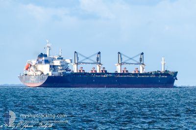
RINIA
Bulk Carrier
Current Trip
| Time Travelled | 18 days |
|---|---|
| Remaining Time | --- |
| Distance Travelled | 3248.40 nm |
| Remaining Distance | --- |
| AVG Speed | 10.4 Knop |
| MAX Speed | 13.5 Knop |
| AVG Wind | 13.2 knots |
| MAX Wind | 27 knots |
| MIN Temp | 10.2°C / 50.36°F |
| MAX Temp | 23.5°C / 74.3°F |
| Djupgående | 11.6 m |
| Position mottagen | 10 h, 11 m sen |
Current Position
| Longitud | -6.06393° |
|---|---|
| Latitude | 48.60020° |
| Status | Under way using engine |
| Fart | 11.3 Knop |
| Kurs | 206.4° |
| Område | Celtic Sea |
| Station | T-AIS |
| Position mottagen | 10 h, 11 m sen |
Info
Information
The current position of RINIA is in Celtic Sea with coordinates 48.60020° / -6.06393° as reported on 2024-06-04 10:51 by AIS to our vessel tracker app. The vessel's current speed is 11.3 Knop and is heading at the port of DURBAN. The estimated time of arrival as calculated by MyShipTracking vessel tracking app is 2024-06-27 08:00 LT
The vessel RINIA (IMO: 9594406, MMSI: 256308000) is a Bulk Carrier that was built in 2012 ( 12 År gammal ). It's sailing under the flag of [MT] Malta.
In this page you can find informations about the vessels current position, last detected port calls, and current voyage information. If the vessels is not in coverage by AIS you will find the latest position.
The current position of RINIA is detected by our AIS receivers and we are not responsible for the reliability of the data. The last position was recorded while the vessel was in Coverage by the Ais receivers of our vessel tracking app.
The current draught of RINIA as reported by AIS is 11.6 meters
Weather
| Temperature | 14.7°C / 58.46°F |
|---|---|
| Wind Speed | 10 knots |
| Direction | 350° N |
| Pressure | 1017.4 hPa |
| Humidity | 79.6 % |
| Cloud Coverage | 100 % |
Featured Company
Most Visited Ports (Last year)
| Port | Arrivals | |
|---|---|---|
| 1 | ||
| 1 | ||
| 1 | ||
| 1 | ||
| 1 | ||
| 1 |
Last Trips
Events
| Tid | Event | Detaljer | Position / Dest | Information |
|---|---|---|---|---|
| 2024-06-04 10:56 | Status ändrad | Default Under way using engine |
48.58333 / -6.07500
DURBAN
|
Fart: 11.3 kn Kurs: 206.4° |
| 2024-06-04 10:51 | Byter havsområde | French part of the Celtic Sea United Kingdom part of the English Channel |
48.60020 / -6.06393
Celtic Sea
DURBAN
|
Fart: 11.3 kn Kurs: 206.4° |
| 2024-06-04 10:51 | UTANFÖR täckningsområde |
48.60020 / -6.06393
Celtic Sea
DURBAN
|
Fart: 11.3 kn Kurs: 206.4° |
|
| 2024-06-04 10:51 | Status ändrad | Under way using engine Default |
48.60114 / -6.06323
DURBAN
|
Fart: 11.5 kn Kurs: 207° |
| 2024-06-04 10:38 | I täckningsområde |
48.60020 / -6.06393
Celtic Sea
DURBAN
|
Fart: 11.3 kn Kurs: 206.4° |
|
| 2024-06-04 03:48 | Status ändrad | Default Under way using engine |
49.44968 / -4.40459
DURBAN
|
Fart: 10.4 kn Kurs: 233.9° |
| 2024-06-04 03:45 | UTANFÖR täckningsområde |
49.45609 / -4.39049
English Channel
DURBAN
|
Fart: 10.4 kn Kurs: 233.9° |
|
| 2024-06-04 03:31 | Status ändrad | Under way using engine Default |
49.47940 / -4.33967
DURBAN
|
Fart: 10.3 kn Kurs: 238° |
| 2024-06-04 03:22 | Status ändrad | Default Under way using engine |
49.49347 / -4.30631
DURBAN
|
Fart: 10.3 kn Kurs: 239.1° |
| 2024-06-04 03:10 | Status ändrad | Under way using engine Default |
49.51018 / -4.26389
DURBAN
|
Fart: 10.3 kn Kurs: 238° |