
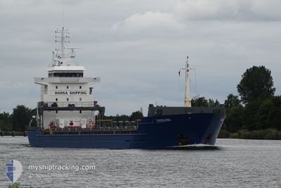
KAROLIINA
General Cargo
Current Trip
| Time Travelled | 19 h, 28 mins |
|---|---|
| Remaining Time | 1 day |
| Distance Travelled | 200.08 nm |
| Remaining Distance | 337.38 nm |
| AVG Speed | 10.4 Knop |
| MAX Speed | 11.1 Knop |
| AVG Wind | 9.2 knots |
| MAX Wind | 12.4 knots |
| MIN Temp | 10.5°C / 50.9°F |
| MAX Temp | 12.8°C / 55.04°F |
| Djupgående | 6.5 m |
| Position mottagen | 1 m sen |
Current Position
| Longitud | 22.52110° |
|---|---|
| Latitude | 59.49196° |
| Status | Under way using engine |
| Fart | 10.5 Knop |
| Kurs | 231.5° |
| Område | Baltic Sea |
| Station | T-AIS |
| Position mottagen | 1 m sen |
Info
Information
The current position of KAROLIINA is in Baltic Sea with coordinates 59.49196° / 22.52110° as reported on 2024-06-12 01:41 by AIS to our vessel tracker app. The vessel's current speed is 10.5 Knop and is heading at the port of GDANSK. The estimated time of arrival as calculated by MyShipTracking vessel tracking app is 2024-06-13 10:59 LT
The vessel KAROLIINA (IMO: 9381380, MMSI: 305201000) is a General Cargo that was built in 2008 ( 16 År gammal ). It's sailing under the flag of [AG] Antigua Barbuda.
In this page you can find informations about the vessels current position, last detected port calls, and current voyage information. If the vessels is not in coverage by AIS you will find the latest position.
The current position of KAROLIINA is detected by our AIS receivers and we are not responsible for the reliability of the data. The last position was recorded while the vessel was in Coverage by the Ais receivers of our vessel tracking app.
The current draught of KAROLIINA as reported by AIS is 6.5 meters
Weather
| Temperature | 11.6°C / 52.88°F |
|---|---|
| Wind Speed | 8 knots |
| Direction | 227° SW |
| Pressure | 1004.7 hPa |
| Humidity | 87.4 % |
| Cloud Coverage | 100 % |
Featured Company
Last Port Calls
| Port | Arrival | Departure | Time In Port |
|---|---|---|---|
| 2024-06-11 09:08 | 2024-06-11 09:14 | 5 m | |
| 2024-06-10 06:37 | 2024-06-11 07:49 | 1 d | |
| 2024-06-08 14:16 | 2024-06-09 13:51 | 23 h | |
| 2024-06-03 06:29 | 2024-06-07 20:30 | 4 d | |
| 2024-05-29 05:51 | 2024-05-31 15:19 | 2 d | |
| 2024-05-21 06:37 | 2024-05-26 22:09 | 5 d | |
| 2024-05-12 05:53 | 2024-05-13 18:53 | 1 d | |
| 2024-05-07 09:06 | 2024-05-09 15:01 | 2 d | |
| 2024-05-02 19:58 | 2024-05-02 20:42 | 44 m | |
| 2024-04-27 18:16 | 2024-04-29 10:57 | 1 d |
Last Trips
| Origin | Departure | Destination | Arrival | Distance | |
|---|---|---|---|---|---|
| 2024-06-11 07:49 | 2024-06-11 09:08 | 6.24 nm | |||
| 2024-06-09 13:51 | 2024-06-10 06:37 | 142.57 nm | |||
| 2024-06-07 20:30 | 2024-06-08 14:16 | 146.58 nm | |||
| 2024-05-31 15:19 | 2024-06-03 06:29 | 576.43 nm | |||
| 2024-05-26 22:09 | 2024-05-29 05:51 | 550.96 nm | |||
| 2024-05-13 18:53 | 2024-05-21 06:37 | 1818.03 nm | |||
| 2024-05-09 15:01 | 2024-05-12 05:53 | 713.95 nm | |||
| 2024-05-02 20:42 | 2024-05-07 09:06 | 1073.12 nm | |||
| 2024-04-29 10:57 | 2024-05-02 19:58 | 838.59 nm | |||
| 2024-04-24 18:32 | 2024-04-27 18:16 | 785.80 nm |
Events
| Tid | Event | Detaljer | Position / Dest | Information |
|---|---|---|---|---|
| 2024-06-11 23:59 | Upptäckt i hav | Finnish part of the Baltic Sea |
59.58980 / 23.08797
Baltic Sea
GDANSK
|
Fart: 10.8 kn Kurs: 254.2° |
| 2024-06-11 19:14 | Byter havsområde | Finnish part of the Gulf of Finland Estonian part of the Gulf of Finland |
59.81638 / 24.71660
Gulf of Finland
GDANSK
|
Fart: 10.6 kn Kurs: 258° |
| 2024-06-11 17:19 | Byter havsområde | Estonian part of the Gulf of Finland Finnish part of the Gulf of Finland |
59.87946 / 25.36634
Gulf of Finland
GDANSK
|
Fart: 10.1 kn Kurs: 260° |
| 2024-06-11 15:52 | Status ändrad | Under way using engine Default |
59.93018 / 25.85534
GDANSK
|
Fart: 10.4 kn Kurs: 252° |
| 2024-06-11 15:49 | Status ändrad | Default Under way using engine |
59.93237 / 25.86897
GDANSK
|
Fart: 10.3 kn Kurs: 255° |
| 2024-06-11 15:12 | Upptäckt i hav | Finnish part of the Gulf of Finland |
59.95989 / 26.07645
Gulf of Finland
GDANSK
|
Fart: 10.6 kn Kurs: 255.5° |
| 2024-06-11 15:12 | Status ändrad | Under way using engine Default |
59.95989 / 26.07645
GDANSK
|
Fart: 10.5 kn Kurs: 256° |
| 2024-06-11 14:57 | Status ändrad | Default Under way using engine |
59.97081 / 26.16042
GDANSK
|
Fart: 10.5 kn Kurs: 255.4° |
| 2024-06-11 14:29 | Byter havsområde | Estonian part of the Gulf of Finland Russian part of the Gulf of Finland |
59.99175 / 26.32354
Gulf of Finland
GDANSK
|
Fart: 10.6 kn Kurs: 255.6° |
| 2024-06-11 08:52 | Destination ändrad | GDANSK PLGDN |
60.34761 / 27.98346
GDANSK
|
Fart: 10.3 kn Kurs: 217.1° |