
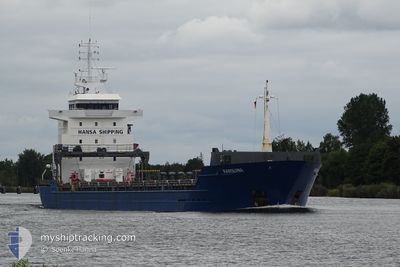
KAROLIINA
General Cargo
Current Trip
| Time Travelled | 2 days |
|---|---|
| Remaining Time | --- |
| Distance Travelled | 558.04 nm |
| Remaining Distance | --- |
| AVG Speed | 9.7 Noeuds |
| MAX Speed | 12.9 Noeuds |
| AVG Wind | 7.7 knots |
| MAX Wind | 18 knots |
| MIN Temp | 9.9°C / 49.82°F |
| MAX Temp | 14.8°C / 58.64°F |
| Tirant d eau | 7.2 m |
| Position reçue | 2 h, 39 m depuis |
Current Position
| Longitude | -2.72807° |
|---|---|
| Latitude | 58.69288° |
| Etat | Under way using engine |
| Vitesse | 9.6 Noeuds |
| Parcours | 96.8° |
| Zone | North Sea |
| Station | T-AIS |
| Position reçue | 2 h, 39 m depuis |
Info
Information
The current position of KAROLIINA is in North Sea with coordinates 58.69288° / -2.72807° as reported on 2024-05-15 22:34 by AIS to our vessel tracker app. The vessel's current speed is 9.6 Noeuds and is heading at the port of ST PETERSBURG. The estimated time of arrival as calculated by MyShipTracking vessel tracking app is 2024-05-20 20:00 LT
The vessel KAROLIINA (IMO: 9381380, MMSI: 305201000) is a General Cargo that was built in 2008 ( 16 Age ). It's sailing under the flag of [AG] Antigua Barbuda.
In this page you can find informations about the vessels current position, last detected port calls, and current voyage information. If the vessels is not in coverage by AIS you will find the latest position.
The current position of KAROLIINA is detected by our AIS receivers and we are not responsible for the reliability of the data. The last position was recorded while the vessel was in Coverage by the Ais receivers of our vessel tracking app.
The current draught of KAROLIINA as reported by AIS is 7.2 meters
Weather
| Temperature | 10.7°C / 51.26°F |
|---|---|
| Wind Speed | 15 knots |
| Direction | 123° ESE |
| Pressure | 1010.3 hPa |
| Humidity | 90.1 % |
| Cloud Coverage | --- |
Featured Company
Last Port Calls
| Port | Arrival | Departure | Time In Port |
|---|---|---|---|
| 2024-05-12 04:53 | 2024-05-13 17:53 | 1 d | |
| 2024-05-07 07:06 | 2024-05-09 13:01 | 2 d | |
| 2024-05-02 17:58 | 2024-05-02 18:42 | 44 m | |
| 2024-04-27 15:16 | 2024-04-29 07:57 | 1 d | |
| 2024-04-24 16:27 | 2024-04-24 16:32 | 4 m | |
| 2024-04-21 22:02 | 2024-04-23 13:06 | 1 d | |
| 2024-04-14 01:54 | 2024-04-16 14:33 | 2 d | |
| 2024-04-12 09:58 | 2024-04-13 18:42 | 1 d | |
| 2024-03-29 18:34 | 2024-03-31 15:37 | 1 d | |
| 2024-03-23 17:44 | 2024-03-25 16:47 | 1 d |
Last Trips
| Origin | Departure | Destination | Arrival | Distance | |
|---|---|---|---|---|---|
| 2024-05-09 15:01 | 2024-05-12 05:53 | 713.95 nm | |||
| 2024-05-02 20:42 | 2024-05-07 09:06 | 1073.12 nm | |||
| 2024-04-29 10:57 | 2024-05-02 19:58 | 838.59 nm | |||
| 2024-04-24 18:32 | 2024-04-27 18:16 | 785.80 nm | |||
| 2024-04-23 15:06 | 2024-04-24 18:27 | 220.21 nm | |||
| 2024-04-16 17:33 | 2024-04-22 00:02 | 1094.87 nm | |||
| 2024-04-13 21:42 | 2024-04-14 04:54 | 52.91 nm | |||
| 2024-03-31 16:37 | 2024-04-12 12:58 | 2277.91 nm | |||
| 2024-03-25 17:47 | 2024-03-29 18:34 | 649.34 nm | |||
| 2024-03-20 04:57 | 2024-03-23 18:44 | 851.47 nm |
Events
| Heure | Evenement | Détails | Position/ Destination | Info |
|---|---|---|---|---|
| 2024-05-15 22:43 | Etat Changé | Default Under way using engine |
58.69015 / -2.68639
RU LED
|
Vitesse: 9.6 kn Parcours: 96.8° |
| 2024-05-15 22:34 | Hors de la zone couverte |
58.69288 / -2.72807
North Sea
RU LED
|
Vitesse: 9.6 kn Parcours: 96.8° |
|
| 2024-05-15 20:08 | Detecté en mer | United Kingdom part of the North Sea |
58.70019 / -3.40756
North Sea
RU LED
|
Vitesse: 9.6 kn Parcours: 85.4° |
| 2024-05-15 17:32 | Etat Changé | Under way using engine Default |
58.68043 / -4.20253
RU LED
|
Vitesse: 10 kn Parcours: 90° |
| 2024-05-15 17:30 | Etat Changé | Default Under way using engine |
58.68034 / -4.21322
RU LED
|
Vitesse: 10 kn Parcours: 86.8° |
| 2024-05-15 16:13 | Etat Changé | Under way using engine Default |
58.66766 / -4.64881
RU LED
|
Vitesse: 11.1 kn Parcours: 88° |
| 2024-05-15 16:11 | Etat Changé | Default Under way using engine |
58.66734 / -4.66144
RU LED
|
Vitesse: 11.1 kn Parcours: 85.5° |
| 2024-05-15 16:04 | Detecté en mer | United Kingdom part of the North Atlantic Ocean |
58.66608 / -4.69803
North Atlantic Ocean
RU LED
|
Vitesse: 11 kn Parcours: 85.1° |
| 2024-05-15 16:04 | Etat Changé | Under way using engine Default |
58.66608 / -4.69803
RU LED
|
Vitesse: 11 kn Parcours: 86° |
| 2024-05-15 15:55 | Dans la zone couverte |
58.66608 / -4.69803
North Atlantic Ocean
RU LED
|
Vitesse: 11 kn Parcours: 85.1° |