
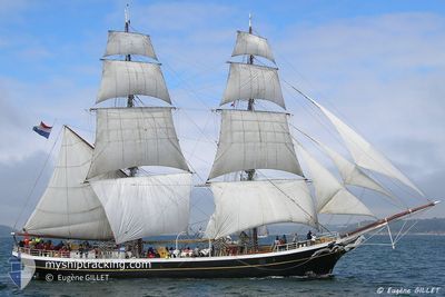
MORGENSTER
Sailing Vessel
Current Trip
| Time Travelled | 9 days |
|---|---|
| Remaining Time | --- |
| Distance Travelled | 519.16 морская миля |
| Remaining Distance | --- |
| AVG Speed | 5.3 Узлы |
| MAX Speed | 7.9 Узлы |
| AVG Wind | 11.1 knots |
| MAX Wind | 17 knots |
| MIN Temp | 8.2°C / 46.76°F |
| MAX Temp | 12.8°C / 55.04°F |
| Осадка | 2.4 м |
| Позиция Получена | 2 h, 30 m тому назад |
Current Position
| Долгота | -3.44850° |
|---|---|
| Широта | 48.83000° |
| Статус | Under way using engine |
| Скорость | 5.7 Узлы |
| Курс | 217° |
| Район | English Channel |
| Станция | T-AIS |
| Позиция Получена | 2 h, 30 m тому назад |
Info
Information
The current position of MORGENSTER is in English Channel with coordinates 48.83000° / -3.44850° as reported on 2024-05-04 06:55 by AIS to our vessel tracker app. The vessel's current speed is 5.7 Узлы and is heading at the port of FECAMP. The estimated time of arrival as calculated by MyShipTracking vessel tracking app is 2024-05-07 20:30 LT
The vessel MORGENSTER (IMO: 5241659, MMSI: 245136000) is a Sailing Vessel that was built in 1919 ( 105 лет ). It's sailing under the flag of [NL] Netherlands.
In this page you can find informations about the vessels current position, last detected port calls, and current voyage information. If the vessels is not in coverage by AIS you will find the latest position.
The current position of MORGENSTER is detected by our AIS receivers and we are not responsible for the reliability of the data. The last position was recorded while the vessel was in Coverage by the Ais receivers of our vessel tracking app.
The current draught of MORGENSTER as reported by AIS is 2.4 meters
Weather
| Temperature | 7.4°C / 45.32°F |
|---|---|
| Wind Speed | 8 knots |
| Direction | 112° ESE |
| Pressure | 1009.5 hPa |
| Humidity | 90.4 % |
| Cloud Coverage | 86 % |
Featured Company
Last Trips
| Origin | Departure | Destination | Arrival | Distance | |
|---|---|---|---|---|---|
| 2024-04-09 14:19 | 2024-04-23 16:33 | 1203.70 морская миля | |||
| 2024-04-08 09:06 | 2024-04-08 20:26 | 47.63 морская миля |
Events
| Время | Событие | Детали | Позиция / Направление | Информация |
|---|---|---|---|---|
| 2024-05-04 06:55 | Вне покрытия |
48.83000 / -3.44850
English Channel
FECAMP
|
Скорость: 5.7 kn Курс: 217° |
|
| 2024-05-04 06:43 | В покрытии |
48.82533 / -3.42367
English Channel
FECAMP
|
Скорость: 7 kn Курс: 327° |
|
| 2024-05-03 17:17 | Вне покрытия |
48.82633 / -3.42367
English Channel
FECAMP
|
Скорость: 4 kn Курс: 155° |
|
| 2024-05-03 16:53 | Начало движения | 10.09 nm, West of TREGUIER |
48.84683 / -3.45883
FECAMP
|
Скорость: 3.1 kn Курс: 125° |
| 2024-05-03 15:39 | Статус изменился | Under way sailing At anchor |
48.87800 / -3.48483
FECAMP
|
Скорость: 0.3 kn Курс: 293° |
| 2024-05-03 13:12 | Статус изменился | At anchor Under way sailing |
48.87767 / -3.48433
FECAMP
|
Скорость: 1 kn Курс: 299° |
| 2024-05-03 13:12 | Окончание движения | 11.78 nm, North West of TREGUIER |
48.87767 / -3.48433
FECAMP
|
Скорость: 0.1 kn Курс: 300° |
| 2024-05-03 07:03 | Начало движения | 0.31 nm, South West of ILE DE BATZ |
48.73517 / -4.01400
FECAMP
|
Скорость: 4.3 kn Курс: 272° |
| 2024-05-03 06:55 | Статус изменился | Under way sailing At anchor |
48.73483 / -4.00967
FECAMP
|
Скорость: 0.2 kn Курс: 215° |
| 2024-05-02 13:30 | Окончание движения | 0.27 nm, South of ILE DE BATZ |
48.73500 / -4.01117
FECAMP
|
Скорость: 0.3 kn Курс: 127° |