
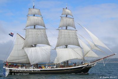
MORGENSTER
Sailing Vessel
Current Trip
| Trip Time | 14 days |
|---|---|
| Trip Distance | 1203.70 nm |
| AVG Speed | 6.2 Knots |
| MAX Speed | 11 Knots |
| Draught | 2.4 m |
| AVG Wind | 10.4 knots |
| MAX Wind | 31.9 knots |
| MIN Temp | 12.1°C / 53.78°F |
| MAX Temp | 21°C / 69.8°F |
| Position Received | 2 m ago |
Current Position
| Longitude | -8.84433° |
|---|---|
| Latitude | 42.12200° |
| Status | Moored |
| Speed | |
| Course | --- |
| Area | North Atlantic Ocean |
| Station | T-AIS |
| Position Received | 2 m ago |
Info
Information
The current position of MORGENSTER is in North Atlantic Ocean with coordinates 42.12200° / -8.84433° as reported on 2024-04-24 22:26 by AIS to our vessel tracker app. The vessel's current speed is 0 Knots and is currently inside the port of BAIONA.
The vessel MORGENSTER (IMO: 5241659, MMSI: 245136000) is a Sailing Vessel that was built in 1919 ( 105 years old ). It's sailing under the flag of [NL] Netherlands.
In this page you can find informations about the vessels current position, last detected port calls, and current voyage information. If the vessels is not in coverage by AIS you will find the latest position.
The current position of MORGENSTER is detected by our AIS receivers and we are not responsible for the reliability of the data. The last position was recorded while the vessel was in Coverage by the Ais receivers of our vessel tracking app.
The current draught of MORGENSTER as reported by AIS is 2.4 meters
Weather
| Temperature | 8.7°C / 47.66°F |
|---|---|
| Wind Speed | 6 knots |
| Direction | 5° N |
| Pressure | 1017.7 hPa |
| Humidity | 83.1 % |
| Cloud Coverage | 49 % |
Featured Company
Last Port Calls
| Port | Arrival | Departure | Time In Port |
|---|---|---|---|
| 2024-04-23 14:33 | |||
| 2024-04-08 18:26 | 2024-04-09 12:19 | 17 h | |
| 2024-04-08 07:06 | |||
| 2024-04-01 13:28 | |||
| 2024-03-25 06:38 | |||
| 2024-02-16 07:53 | 2024-02-18 14:07 | 2 d | |
| 2024-02-04 11:22 | 2024-02-07 04:31 | 2 d | |
| 2024-02-03 16:12 |
Last Trips
| Origin | Departure | Destination | Arrival | Distance | |
|---|---|---|---|---|---|
| 2024-04-09 14:19 | 2024-04-23 16:33 | 1203.70 nm | |||
| 2024-04-08 09:06 | 2024-04-08 20:26 | 47.63 nm | |||
| 2024-02-07 05:31 | 2024-02-16 08:53 | 897.45 nm | |||
| 2024-02-03 17:12 | 2024-02-04 12:22 | 117.92 nm |
Events
| Time | Event | Details | Position / Dest | Info |
|---|---|---|---|---|
| 2024-04-23 14:56 | Status Changed | Moored Under way using engine |
42.12200 / -8.84433
[ES] BAIONA
|
Speed: Course: 23° |
| 2024-04-23 14:36 | STOP Moving |
42.12167 / -8.84317
[ES] BAIONA
|
Speed: 0.3 kn Course: 284° |
|
| 2024-04-23 14:33 | PORT ARRIVAL |
|
42.12283 / -8.84183
[ES] BAIONA
|
Speed: 4.7 kn Course: 224° |
| 2024-04-23 14:01 | Change Sea Area | Spanish part of the North Atlantic Ocean Portuguese part of the North Atlantic Ocean |
42.13317 / -8.87533
North Atlantic Ocean
FECAMP
|
Speed: 6.1 kn Course: 98° |
| 2024-04-23 13:59 | IN Coverage |
42.13317 / -8.87533
North Atlantic Ocean
FECAMP
|
Speed: 6.1 kn Course: 98° |
|
| 2024-04-23 08:07 | OUT of Coverage |
41.59083 / -8.94550
North Atlantic Ocean
FECAMP
|
Speed: 5.9 kn Course: 0° |
|
| 2024-04-23 08:07 | IN Coverage |
41.59083 / -8.94550
North Atlantic Ocean
FECAMP
|
Speed: 5.9 kn Course: 0° |
|
| 2024-04-23 01:23 | OUT of Coverage |
40.83800 / -9.11217
North Atlantic Ocean
FECAMP
|
Speed: 7.4 kn Course: 7° |
|
| 2024-04-21 17:56 | IN Coverage |
37.57350 / -9.23933
North Atlantic Ocean
FECAMP
|
Speed: 5.7 kn Course: 336° |
|
| 2024-04-21 15:16 | OUT of Coverage |
37.31017 / -9.14483
North Atlantic Ocean
FECAMP
|
Speed: 5.8 kn Course: 346° |