
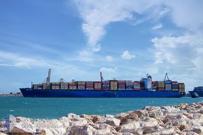
MAERSK PUELO
Container Ship
Current Trip
| Time Travelled | 1 day |
|---|---|
| Remaining Time | --- |
| Distance Travelled | 284.82 nm |
| Remaining Distance | 12.79 nm |
| AVG Speed | 11.2 Noeuds |
| MAX Speed | 19.1 Noeuds |
| AVG Wind | 11.7 knots |
| MAX Wind | 20 knots |
| MIN Temp | 13.9°C / 57.02°F |
| MAX Temp | 17.5°C / 63.5°F |
| Tirant d eau | 12.3 m |
| Position reçue | Maintenant |
Current Position
| Longitude | -8.99779° |
|---|---|
| Latitude | 37.71547° |
| Etat | Under way using engine |
| Vitesse | 1.5 Noeuds |
| Parcours | 73° |
| Zone | North Atlantic Ocean |
| Station | T-AIS |
| Position reçue | Maintenant |
Info
Information
The current position of MAERSK PUELO is in North Atlantic Ocean with coordinates 37.71547° / -8.99779° as reported on 2024-05-21 11:59 by AIS to our vessel tracker app. The vessel's current speed is 1.5 Noeuds and is heading at the port of SINES. The estimated time of arrival as calculated by MyShipTracking vessel tracking app is 2024-05-21 01:00 LT
The vessel MAERSK PUELO (IMO: 9306172, MMSI: 353117000) is a Container Ship that was built in 2006 ( 18 Age ). It's sailing under the flag of [PA] Panama.
In this page you can find informations about the vessels current position, last detected port calls, and current voyage information. If the vessels is not in coverage by AIS you will find the latest position.
The current position of MAERSK PUELO is detected by our AIS receivers and we are not responsible for the reliability of the data. The last position was recorded while the vessel was in Coverage by the Ais receivers of our vessel tracking app.
The current draught of MAERSK PUELO as reported by AIS is 12.3 meters
Weather
| Temperature | 15.9°C / 60.62°F |
|---|---|
| Wind Speed | 10 knots |
| Direction | 326° NW |
| Pressure | 1021.3 hPa |
| Humidity | 77.8 % |
| Cloud Coverage | 1 % |
Featured Company
Last Port Calls
| Port | Arrival | Departure | Time In Port |
|---|---|---|---|
| 2024-05-19 17:01 | 2024-05-20 06:59 | 13 h | |
| 2024-05-17 19:52 | 2024-05-18 15:19 | 19 h | |
| 2024-05-15 12:56 | 2024-05-16 00:38 | 11 h | |
| 2024-05-09 15:34 | 2024-05-11 08:06 | 1 d | |
| 2024-05-05 09:14 | 2024-05-07 08:01 | 1 d | |
| 2024-04-30 18:25 | 2024-05-01 17:40 | 23 h | |
| 2024-04-25 17:20 | 2024-04-26 08:06 | 14 h | |
| 2024-04-13 05:32 | 2024-04-14 07:43 | 1 d | |
| 2024-04-08 18:33 | 2024-04-10 18:58 | 2 d | |
| 2024-04-05 02:48 | 2024-04-05 22:33 | 19 h |
Last Trips
| Origin | Departure | Destination | Arrival | Distance | |
|---|---|---|---|---|---|
| 2024-05-18 17:19 | 2024-05-19 19:01 | 403.92 nm | |||
| 2024-05-16 02:38 | 2024-05-17 21:52 | 195.55 nm | |||
| 2024-05-11 10:06 | 2024-05-15 14:56 | 466.80 nm | |||
| 2024-05-07 10:01 | 2024-05-09 17:34 | 378.24 nm | |||
| 2024-05-01 19:40 | 2024-05-05 11:14 | 331.06 nm | |||
| 2024-04-26 10:06 | 2024-04-30 20:25 | 1073.82 nm | |||
| 2024-04-14 02:43 | 2024-04-25 19:20 | 4683.10 nm | |||
| 2024-04-10 13:58 | 2024-04-13 00:32 | 473.91 nm | |||
| 2024-04-05 16:33 | 2024-04-08 13:33 | 507.48 nm | |||
| 2024-03-30 07:22 | 2024-04-04 20:48 | 1322.50 nm |
Events
| Heure | Evenement | Détails | Position/ Destination | Info |
|---|---|---|---|---|
| 2024-05-21 07:29 | Arret | 13.7 nm, South West of SINES |
37.78638 / -9.07523
PTSIE
|
Vitesse: 0.3 kn Parcours: 320° |
| 2024-05-20 23:10 | Etat Changé | Under way using engine Default |
37.24538 / -9.20340
PTSIE
|
Vitesse: 10.6 kn Parcours: 27° |
| 2024-05-20 23:02 | Dans la zone couverte |
37.24538 / -9.20340
North Atlantic Ocean
PTSIE
|
Vitesse: 10.7 kn Parcours: 25.8° |
|
| 2024-05-20 21:14 | Etat Changé | Default Under way using engine |
36.93356 / -9.33227
PTSIE
|
Vitesse: 10.5 kn Parcours: 353.8° |
| 2024-05-20 21:09 | Etat Changé | Under way using engine Default |
36.91713 / -9.33009
PTSIE
|
Vitesse: 10.4 kn Parcours: 354° |
| 2024-05-20 21:09 | Hors de la zone couverte |
36.91713 / -9.33009
North Atlantic Ocean
PTSIE
|
Vitesse: 10.5 kn Parcours: 353.8° |
|
| 2024-05-20 21:02 | Etat Changé | Default Under way using engine |
36.89854 / -9.32743
PTSIE
|
Vitesse: 10.5 kn Parcours: 346.6° |
| 2024-05-20 20:56 | Etat Changé | Under way using engine Default |
36.88032 / -9.32404
PTSIE
|
Vitesse: 10.4 kn Parcours: 339° |
| 2024-05-20 20:38 | Dans la zone couverte |
36.88032 / -9.32404
North Atlantic Ocean
PTSIE
|
Vitesse: 10.5 kn Parcours: 346.6° |
|
| 2024-05-20 19:00 | Hors de la zone couverte |
36.69639 / -8.98222
North Atlantic Ocean
PTSIE
|
Vitesse: 10.9 kn Parcours: 283.9° |