
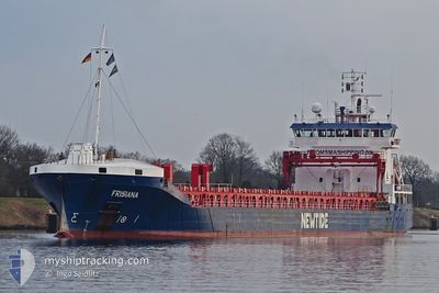
FRISIANA
General Cargo
Current Trip
LONGVHOWN
| Time Travelled | 15 days |
|---|---|
| Remaining Time | --- |
| Distance Travelled | 3428.71 nm |
| Remaining Distance | --- |
| AVG Speed | 11.1 Noeuds |
| MAX Speed | 14 Noeuds |
| AVG Wind | 9.1 knots |
| MAX Wind | 19.1 knots |
| MIN Temp | 21.8°C / 71.24°F |
| MAX Temp | 30.9°C / 87.62°F |
| Tirant d eau | 5.2 m |
| Position reçue | 8 d depuis |
Current Position
| Longitude | -79.46036° |
|---|---|
| Latitude | 8.57499° |
| Etat | Under way using engine |
| Vitesse | 11 Noeuds |
| Parcours | 178° |
| Zone | North Pacific Ocean |
| Station | T-AIS |
| Position reçue | 8 d depuis |
Info
Information
The current position of FRISIANA is in North Pacific Ocean with coordinates 8.57499° / -79.46036° as reported on 2024-06-05 19:34 by AIS to our vessel tracker app. The vessel's current speed is 11 Noeuds
The vessel FRISIANA (IMO: 9385893, MMSI: 246602000) is a General Cargo that was built in 2010 ( 14 Age ). It's sailing under the flag of [NL] Netherlands.
In this page you can find informations about the vessels current position, last detected port calls, and current voyage information. If the vessels is not in coverage by AIS you will find the latest position.
The current position of FRISIANA is detected by our AIS receivers and we are not responsible for the reliability of the data. The last position was recorded while the vessel was in Coverage by the Ais receivers of our vessel tracking app.
The current draught of FRISIANA as reported by AIS is 5.2 meters
Weather
| Temperature | 21.9°C / 71.42°F |
|---|---|
| Wind Speed | 5 knots |
| Direction | 293° WNW |
| Pressure | 1011.1 hPa |
| Humidity | 80.1 % |
| Cloud Coverage | 30 % |
Featured Company
Last Port Calls
| Port | Arrival | Departure | Time In Port |
|---|---|---|---|
| 2024-05-28 06:10 | 2024-05-29 01:25 | 19 h | |
| 2024-05-23 16:13 | 2024-05-27 10:25 | 3 d | |
| 2024-05-22 07:06 | 2024-05-23 12:53 | 1 d | |
| 2024-05-02 15:51 | 2024-05-08 12:24 | 5 d | |
| 2024-04-25 17:12 | 2024-04-29 21:31 | 4 d | |
| 2024-04-16 21:00 | 2024-04-21 08:13 | 4 d | |
| 2024-04-13 02:46 | 2024-04-15 23:42 | 2 d | |
| 2024-04-01 15:44 | 2024-04-03 08:16 | 1 d |
Last Trips
| Origin | Departure | Destination | Arrival | Distance | |
|---|---|---|---|---|---|
| 2024-05-27 10:25 | 2024-05-28 06:10 | 116.30 nm | |||
| 2024-05-23 12:53 | 2024-05-23 16:13 | 29.22 nm | |||
| 2024-05-08 12:24 | 2024-05-22 07:06 | 3550.91 nm | |||
| 2024-04-29 21:31 | 2024-05-02 15:51 | 648.97 nm | |||
| 2024-04-21 08:13 | 2024-04-25 17:12 | 1056.61 nm | |||
| 2024-04-15 23:42 | 2024-04-16 21:00 | 95.53 nm | |||
| 2024-04-03 08:16 | 2024-04-13 02:46 | 993.90 nm | |||
| 2024-03-27 13:51 | 2024-04-01 15:44 | 675.53 nm |
Events
| Heure | Evenement | Détails | Position/ Destination | Info |
|---|---|---|---|---|
| 2024-06-05 19:34 | Hors de la zone couverte |
8.57499 / -79.46036
North Pacific Ocean
LONGVHOWN
|
Vitesse: 11 kn Parcours: 178° |
|
| 2024-06-05 19:24 | Etat Changé | Under way using engine Default |
8.60839 / -79.46041
LONGVHOWN
|
Vitesse: 11.2 kn Parcours: 181° |
| 2024-06-05 18:59 | Etat Changé | Default Under way using engine |
8.68475 / -79.46043
LONGVHOWN
|
Vitesse: 11 kn Parcours: 181° |
| 2024-06-05 18:51 | Etat Changé | Under way using engine Default |
8.71195 / -79.46043
LONGVHOWN
|
Vitesse: 11.3 kn Parcours: 159° |
| 2024-06-05 18:38 | Etat Changé | Default Under way using engine |
8.75027 / -79.46512
LONGVHOWN
|
Vitesse: 11 kn Parcours: 93° |
| 2024-06-05 18:10 | Etat Changé | Under way using engine Default |
8.82186 / -79.50515
LONGVHOWN
|
Vitesse: 7.3 kn Parcours: 98° |
| 2024-06-05 18:02 | Démarrage | 0.99 nm, North of TABOGUILLA |
8.82426 / -79.52669
LONGVHOWN
|
Vitesse: 7.3 kn Parcours: 98° |
| 2024-06-05 17:37 | Etat Changé | Default At anchor |
8.82674 / -79.53415
LONGVHOWN
|
Vitesse: Parcours: 146° |
| 2024-06-05 17:10 | Etat Changé | At anchor Default |
8.82673 / -79.53391
LONGVHOWN
|
Vitesse: 0.1 kn Parcours: 163° |
| 2024-06-05 16:58 | Dans la zone couverte |
8.82673 / -79.53391
North Pacific Ocean
LONGVHOWN
|
Vitesse: Parcours: 146° |