
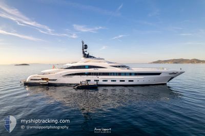
YALLA
Pleasure Craft
Current Trip
| Trip Time | 3 days |
|---|---|
| Trip Distance | 213.66 nm |
| AVG Speed | 10.7 Knots |
| MAX Speed | 14.3 Knots |
| Draught | 3.4 m |
| AVG Wind | 5.7 knots |
| MAX Wind | 20 knots |
| MIN Temp | 13.6°C / 56.48°F |
| MAX Temp | 23.2°C / 73.76°F |
| Position Received | 1 m ago |
Current Position
| Longitude | 7.42435° |
|---|---|
| Latitude | 43.73658° |
| Status | Moored |
| Speed | |
| Course | 172° |
| Area | Mediterranean Sea - Western Basin |
| Station | T-AIS |
| Position Received | 1 m ago |
Info
Information
The current position of YALLA is in Mediterranean Sea - Western Basin with coordinates 43.73658° / 7.42435° as reported on 2024-06-03 17:31 by AIS to our vessel tracker app. The vessel's current speed is 0 Knots and is currently inside the port of MONACO.
The vessel YALLA (IMO: 1012220, MMSI: 256032000) is a Pleasure Craft It's sailing under the flag of [MT] Malta.
In this page you can find informations about the vessels current position, last detected port calls, and current voyage information. If the vessels is not in coverage by AIS you will find the latest position.
The current position of YALLA is detected by our AIS receivers and we are not responsible for the reliability of the data. The last position was recorded while the vessel was in Coverage by the Ais receivers of our vessel tracking app.
The current draught of YALLA as reported by AIS is 3.4 meters
Weather
| Temperature | 18.7°C / 65.66°F |
|---|---|
| Wind Speed | 6 knots |
| Direction | 228° SW |
| Pressure | 1013.4 hPa |
| Humidity | 73.8 % |
| Cloud Coverage | --- |
Featured Company
Last Port Calls
| Port | Arrival | Departure | Time In Port |
|---|---|---|---|
| 2024-05-27 15:47 | |||
| 2024-05-23 18:02 | 2024-05-23 18:09 | 7 m | |
| 2024-05-23 16:32 | 2024-05-23 16:34 | 2 m | |
| 2024-05-23 15:50 | 2024-05-23 15:54 | 4 m | |
| 2024-05-23 15:06 | 2024-05-23 15:09 | 3 m | |
| 2024-05-23 13:42 | 2024-05-23 13:45 | 3 m | |
| 2024-05-23 13:29 | 2024-05-23 13:33 | 4 m | |
| 2024-05-23 11:30 | 2024-05-23 11:39 | 9 m | |
| 2024-05-19 07:38 | 2024-05-21 10:23 | 2 d | |
| 2024-05-06 07:17 |
Most Visited Ports (Last year)
| Port | Arrivals | |
|---|---|---|
| 8 | ||
| 4 | ||
| 3 | ||
| 2 | ||
| 1 | ||
| 1 |
Last Trips
| Origin | Departure | Destination | Arrival | Distance | |
|---|---|---|---|---|---|
| 2024-05-23 20:09 | 2024-05-27 17:47 | 213.66 nm | |||
| 2024-05-23 18:34 | 2024-05-23 20:02 | 0.61 nm | |||
| 2024-05-23 17:54 | 2024-05-23 18:32 | 0.73 nm | |||
| 2024-05-23 17:09 | 2024-05-23 17:50 | 1.02 nm | |||
| 2024-05-23 15:45 | 2024-05-23 17:06 | 1.37 nm | |||
| 2024-05-23 15:33 | 2024-05-23 15:42 | 0.75 nm | |||
| 2024-05-23 13:39 | 2024-05-23 15:29 | 1.17 nm | |||
| 2024-05-21 12:23 | 2024-05-23 13:30 | 41.94 nm | |||
| 2024-05-06 09:17 | 2024-05-19 09:38 | 1018.55 nm | |||
| 2024-04-04 09:08 | 2024-04-04 13:18 | 47.51 nm |
Events
| Time | Event | Details | Position / Dest | Info |
|---|---|---|---|---|
| 2024-06-01 00:03 | ETA Changed | 2025/05/26 03:41 2024/05/26 03:41 |
43.73658 / 7.42435
[MC] MONACO
|
Speed: Course: 172° |
| 2024-05-27 16:17 | Status Changed | Moored Under way using engine |
43.73659 / 7.42437
[MC] MONACO
|
Speed: Course: 170° |
| 2024-05-27 15:56 | STOP Moving |
43.73515 / 7.42492
[MC] MONACO
|
Speed: 0.3 kn Course: 179° |
|
| 2024-05-27 15:47 | PORT ARRIVAL |
|
43.73687 / 7.43112
[MC] MONACO
|
Speed: 3.4 kn Course: 221° |
| 2024-05-27 15:44 | START Moving | 0.83 nm, North East of MONACO |
43.73914 / 7.43478
MONACO
|
Speed: 3.3 kn Course: 246° |
| 2024-05-27 15:36 | STOP Moving | 0.94 nm, North East of MONACO |
43.73849 / 7.43879
MONACO
|
Speed: 0.3 kn Course: 274° |
| 2024-05-27 15:13 | Change Sea Area | Mon�gasque part of the Mediterranean Sea - Western Basin French part of the Mediterranean Sea - Western Basin |
43.72103 / 7.42679
Mediterranean Sea - Western Basin
|
Speed: 9.9 kn Course: 44.6° |
| 2024-05-27 12:12 | Destination Changed | MONACO HYERES |
43.29033 / 6.86773
MONACO
|
Speed: 11.6 kn Course: 43.5° |
| 2024-05-27 11:46 | IN Coverage |
43.22933 / 6.78857
Mediterranean Sea - Western Basin
|
Speed: 11.6 kn Course: 42.7° |
|
| 2024-05-27 10:28 | OUT of Coverage |
43.09226 / 6.49474
Mediterranean Sea - Western Basin
|
Speed: 12.2 kn Course: 66.1° |