
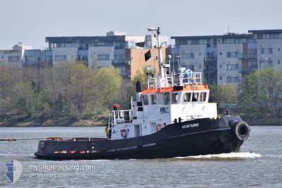
VENTURE
Tug
Current Trip
| Trip Time | 2 days |
|---|---|
| Trip Distance | 85.83 nm |
| AVG Speed | 3.3 Knots |
| MAX Speed | 10 Knots |
| Draught | 3.9 m |
| AVG Wind | 9.1 knots |
| MAX Wind | 14.9 knots |
| MIN Temp | 1.4°C / 34.52°F |
| MAX Temp | 9.5°C / 49.1°F |
| Position Received | 2 d ago |
Current Position
| Longitude | 1.78903° |
|---|---|
| Latitude | 52.40570° |
| Status | Towing Astern |
| Speed | 1.7 Knots |
| Course | 223° |
| Area | North Sea |
| Station | T-AIS |
| Position Received | 2 d ago |
Info
Information
The current position of VENTURE is in North Sea with coordinates 52.40570° / 1.78903° as reported on 2024-04-26 05:36 by AIS to our vessel tracker app. The vessel's current speed is 1.7 Knots and is currently inside the port of GREAT YARMOUTH.
The vessel VENTURE (IMO: 7529469, MMSI: 235106674) is a Tug It's sailing under the flag of [GB] United Kingdom.
In this page you can find informations about the vessels current position, last detected port calls, and current voyage information. If the vessels is not in coverage by AIS you will find the latest position.
The current position of VENTURE is detected by our AIS receivers and we are not responsible for the reliability of the data. The last position was recorded while the vessel was in Coverage by the Ais receivers of our vessel tracking app.
The current draught of VENTURE as reported by AIS is 3.9 meters
Weather
| Temperature | 7.5°C / 45.5°F |
|---|---|
| Wind Speed | 18 knots |
| Direction | 269° W |
| Pressure | 1001.9 hPa |
| Humidity | 89.9 % |
| Cloud Coverage | 100 % |
Featured Company
Last Port Calls
| Port | Arrival | Departure | Time In Port |
|---|---|---|---|
| 2024-04-27 12:20 | |||
| 2024-04-14 20:42 | 2024-04-24 21:12 | 10 d | |
| 2024-04-11 22:49 | 2024-04-12 04:18 | 5 h | |
| 2024-04-06 16:43 | 2024-04-09 14:39 | 2 d | |
| 2024-04-03 13:59 | 2024-04-06 15:43 | 3 d | |
| 2024-03-22 17:00 | 2024-04-03 12:31 | 11 d | |
| 2024-03-21 13:14 | 2024-03-21 16:14 | 3 h | |
| 2024-03-19 22:48 | 2024-03-20 06:22 | 7 h | |
| 2024-03-10 03:38 | 2024-03-15 09:33 | 5 d | |
| 2024-03-07 20:33 | 2024-03-07 23:35 | 3 h |
Last Trips
| Origin | Departure | Destination | Arrival | Distance | |
|---|---|---|---|---|---|
| 2024-04-24 22:12 | 2024-04-27 13:20 | 85.83 nm | |||
| 2024-04-12 05:18 | 2024-04-14 21:42 | 114.30 nm | |||
| 2024-04-09 15:39 | 2024-04-11 23:49 | 325.79 nm | |||
| 2024-04-06 16:43 | 2024-04-06 17:43 | 7.96 nm | |||
| 2024-04-03 13:31 | 2024-04-03 14:59 | 9.48 nm | |||
| 2024-03-21 16:14 | 2024-03-22 17:00 | 68.25 nm | |||
| 2024-03-20 06:22 | 2024-03-21 13:14 | 333.32 nm | |||
| 2024-03-15 09:33 | 2024-03-19 22:48 | 706.26 nm | |||
| 2024-03-07 23:35 | 2024-03-10 03:38 | 414.67 nm | |||
| 2024-03-02 13:16 | 2024-03-07 20:33 | 1012.59 nm |
Events
| Time | Event | Details | Position / Dest | Info |
|---|---|---|---|---|
| 2024-04-27 12:24 | STOP Moving |
52.58049 / 1.73243
[GB] GREAT YARMOUTH
|
Speed: Course: 356° |
|
| 2024-04-27 12:20 | PORT ARRIVAL |
|
52.58037 / 1.73224
[GB] GREAT YARMOUTH
|
Speed: 3.7 kn Course: 356° |
| 2024-04-27 06:00 | START Moving | 4.31 nm, South of LOWESTOFT |
52.40338 / 1.76560
BENACRES TOW>220M
|
Speed: 4.5 kn Course: 28° |
| 2024-04-27 02:56 | STOP Moving | 4.68 nm, South of LOWESTOFT |
52.39723 / 1.76587
BENACRES TOW>220M
|
Speed: 0.3 kn Course: 201° |
| 2024-04-27 02:36 | START Moving | 4.62 nm, South of LOWESTOFT |
52.39672 / 1.75127
BENACRES TOW>220M
|
Speed: 4.4 kn Course: 134° |
| 2024-04-26 07:30 | STOP Moving | 4.65 nm, South of LOWESTOFT |
52.39600 / 1.74325
BENACRES TOW>220M
|
Speed: 0.3 kn Course: 24° |
| 2024-04-26 07:05 | START Moving | 4.17 nm, North East of SOUTHWOLD |
52.37537 / 1.76560
BENACRES TOW>220M
|
Speed: 7.4 kn Course: 41° |
| 2024-04-26 06:52 | STOP Moving | 4.15 nm, North East of SOUTHWOLD |
52.37654 / 1.76327
BENACRES TOW>220M
|
Speed: 0.3 kn Course: 15° |
| 2024-04-26 05:40 | Status Changed | Default Towing Astern |
52.40406 / 1.78657
BENACRES TOW>220M
|
Speed: 1.7 kn Course: 223° |
| 2024-04-26 05:36 | OUT of Coverage |
52.40570 / 1.78903
North Sea
|
Speed: 1.7 kn Course: 220.1° |