
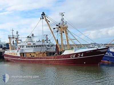
UK34 KOBUS JR
Trawler
Current Trip
HARLINGEN
| Time Travelled | 4 days |
|---|---|
| Remaining Time | --- |
| Distance Travelled | 245.40 nm |
| Remaining Distance | --- |
| AVG Speed | 7.9 Knots |
| MAX Speed | 11.7 Knots |
| AVG Wind | 9.1 knots |
| MAX Wind | 24.2 knots |
| MIN Temp | 3.8°C / 38.84°F |
| MAX Temp | 7°C / 44.6°F |
| Draught | 5.2 m |
| Position Received | Now |
Current Position
| Longitude | 7.81524° |
|---|---|
| Latitude | 56.81001° |
| Status | Under way using engine |
| Speed | 9.4 Knots |
| Course | 120.4° |
| Area | North Sea |
| Station | T-AIS |
| Position Received | Now |
Info
Information
The current position of UK34 KOBUS JR is in North Sea with coordinates 56.81001° / 7.81524° as reported on 2024-04-26 08:07 by AIS to our vessel tracker app. The vessel's current speed is 9.4 Knots
The vessel UK34 KOBUS JR (IMO: 9039212, MMSI: 246009000) is a Trawler that was built in 1992 ( 32 years old ). It's sailing under the flag of [NL] Netherlands.
In this page you can find informations about the vessels current position, last detected port calls, and current voyage information. If the vessels is not in coverage by AIS you will find the latest position.
The current position of UK34 KOBUS JR is detected by our AIS receivers and we are not responsible for the reliability of the data. The last position was recorded while the vessel was in Coverage by the Ais receivers of our vessel tracking app.
The current draught of UK34 KOBUS JR as reported by AIS is 5.2 meters
Weather
| Temperature | 6.1°C / 42.98°F |
|---|---|
| Wind Speed | 19 knots |
| Direction | 90° E |
| Pressure | 1004.8 hPa |
| Humidity | 78.2 % |
| Cloud Coverage | 89 % |
Featured Company
Last Port Calls
| Port | Arrival | Departure | Time In Port |
|---|---|---|---|
| 2024-04-19 11:05 | 2024-04-22 06:04 | 2 d | |
| 2024-04-12 10:31 | 2024-04-15 07:39 | 2 d | |
| 2024-04-05 18:29 | 2024-04-08 06:39 | 2 d | |
| 2024-03-29 03:03 | 2024-04-02 06:03 | 4 d | |
| 2024-03-22 12:42 | 2024-03-25 08:02 | 2 d | |
| 2024-03-15 18:57 | 2024-03-18 00:47 | 2 d | |
| 2024-03-08 18:44 | 2024-03-11 01:09 | 2 d | |
| 2024-03-01 13:19 | 2024-03-04 00:56 | 2 d | |
| 2024-02-23 16:05 | 2024-02-26 00:42 | 2 d | |
| 2024-02-10 04:49 | 2024-02-19 01:00 | 8 d |
Last Trips
| Origin | Departure | Destination | Arrival | Distance | |
|---|---|---|---|---|---|
| 2024-04-15 09:39 | 2024-04-19 13:05 | 219.52 nm | |||
| 2024-04-08 08:39 | 2024-04-12 12:31 | 282.39 nm | |||
| 2024-04-02 08:03 | 2024-04-05 20:29 | 115.34 nm | |||
| 2024-03-25 09:02 | 2024-03-29 04:03 | 102.21 nm | |||
| 2024-03-18 01:47 | 2024-03-22 13:42 | 326.91 nm | |||
| 2024-03-11 02:09 | 2024-03-15 19:57 | 356.00 nm | |||
| 2024-03-04 01:56 | 2024-03-08 19:44 | 587.09 nm | |||
| 2024-02-26 01:42 | 2024-03-01 14:19 | 80.59 nm | |||
| 2024-02-19 02:00 | 2024-02-23 17:05 | 78.13 nm | |||
| 2024-02-06 20:44 | 2024-02-10 05:49 | 60.24 nm |
Events
| Time | Event | Details | Position / Dest | Info |
|---|---|---|---|---|
| 2024-04-26 06:22 | IN Coverage |
56.87860 / 7.45866
North Sea
|
Speed: 0.7 kn Course: 322.4° |
|
| 2024-04-26 01:27 | OUT of Coverage |
57.07544 / 6.67939
North Sea
|
Speed: 6.1 kn Course: 89° |
|
| 2024-04-26 01:27 | IN Coverage |
57.07544 / 6.67939
North Sea
|
Speed: 6.1 kn Course: 89° |
|
| 2024-04-25 20:11 | OUT of Coverage |
57.08196 / 6.71722
North Sea
|
Speed: 6.3 kn Course: 87.9° |
|
| 2024-04-25 19:13 | IN Coverage |
57.03775 / 6.55883
North Sea
|
Speed: 5 kn Course: 100.2° |
|
| 2024-04-25 17:49 | OUT of Coverage |
57.08636 / 6.76293
North Sea
|
Speed: 6.1 kn Course: 245.2° |
|
| 2024-04-25 17:37 | IN Coverage |
57.09407 / 6.79502
North Sea
|
Speed: 6.1 kn Course: 257.4° |
|
| 2024-04-25 16:21 | OUT of Coverage |
57.09570 / 6.82231
North Sea
|
Speed: 6.1 kn Course: 77.6° |
|
| 2024-04-25 16:21 | IN Coverage |
57.09570 / 6.82231
North Sea
|
Speed: 6.1 kn Course: 77.6° |
|
| 2024-04-25 12:44 | OUT of Coverage |
57.11307 / 6.79486
North Sea
|
Speed: 6.3 kn Course: 110.2° |