
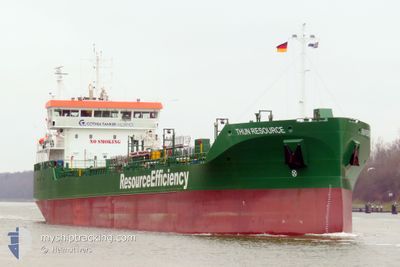
THUN RESOURCE
Tanker
Current Trip
| Trip Time | 4 days |
|---|---|
| Trip Distance | 754.14 nm |
| AVG Speed | 10.4 Knots |
| MAX Speed | 12.9 Knots |
| Draught | 6.8 m |
| AVG Wind | 15.9 knots |
| MAX Wind | 27.3 knots |
| MIN Temp | 1.2°C / 34.16°F |
| MAX Temp | 8.9°C / 48.02°F |
| Position Received | 8 h, 27 m ago |
Current Position
| Longitude | --- |
|---|---|
| Latitude | --- |
| Status | Under way using engine |
| Speed | 9.2 Knots |
| Course | 198.3° |
| Area | Baltic Sea |
| Station | T-AIS |
| Position Received | 8 h, 27 m ago |
Info
Information
The current position of THUN RESOURCE is in Baltic Sea with coordinates 57.06710° / 16.72191° as reported on 2025-12-23 05:56 by AIS to our vessel tracker app. The vessel's current speed is 9.2 Knots and is currently inside the port of KALMAR.
The vessel THUN RESOURCE (IMO: 9970507, MMSI: 245313000) is a Tanker It's sailing under the flag of [NL] Netherlands.
In this page you can find informations about the vessels current position, last detected port calls, and current voyage information. If the vessels is not in coverage by AIS you will find the latest position.
The current position of THUN RESOURCE is detected by our AIS receivers and we are not responsible for the reliability of the data. The last position was recorded while the vessel was in Coverage by the Ais receivers of our vessel tracking app.
The current draught of THUN RESOURCE as reported by AIS is 6.8 meters
Weather
| Temperature | 4°C / 39.2°F |
|---|---|
| Wind Speed | 9 knots |
| Direction | 82° E |
| Pressure | 1030.7 hPa |
| Humidity | 77.4 % |
| Cloud Coverage | 98 % |
Featured Company
Last Port Calls
| Port | Arrival | Departure | Time In Port |
|---|---|---|---|
| 2025-12-23 10:18 | |||
| 2025-12-18 17:50 | 2025-12-19 05:43 | 11 h | |
| 2025-12-16 07:34 | 2025-12-16 19:53 | 12 h | |
| 2025-12-13 08:40 | 2025-12-15 09:44 | 2 d | |
| 2025-12-09 15:49 | 2025-12-10 06:49 | 14 h | |
| 2025-12-03 05:27 | 2025-12-04 13:24 | 1 d | |
| 2025-11-29 11:25 | 2025-11-30 01:09 | 13 h | |
| 2025-11-21 23:35 | 2025-11-23 11:18 | 1 d | |
| 2025-11-20 12:14 | 2025-11-20 13:36 | 1 h | |
| 2025-11-18 03:36 | 2025-11-18 23:36 | 19 h |
Last Trips
| Origin | Departure | Destination | Arrival | Distance | |
|---|---|---|---|---|---|
| 2025-12-19 05:43 | 2025-12-23 10:18 | 754.14 nm | |||
| 2025-12-16 19:53 | 2025-12-18 17:50 | 523.32 nm | |||
| 2025-12-15 09:44 | 2025-12-16 07:34 | 238.67 nm | |||
| 2025-12-10 06:49 | 2025-12-13 08:40 | 689.02 nm | |||
| 2025-12-04 13:24 | 2025-12-09 15:49 | 989.57 nm | |||
| 2025-11-30 01:09 | 2025-12-03 05:27 | 684.49 nm | |||
| 2025-11-23 11:18 | 2025-11-29 11:25 | 992.19 nm | |||
| 2025-11-20 13:36 | 2025-11-21 23:35 | 347.42 nm | |||
| 2025-11-18 23:36 | 2025-11-20 12:14 | 337.26 nm | |||
| 2025-11-13 01:00 | 2025-11-18 03:36 | 1006.99 nm |
Events
| Time | Event | Details | Position / Dest | Info |
|---|---|---|---|---|
| 2025-12-23 09:22 | STOP Moving |
56.65745 / 16.37737
[SE] KALMAR
|
Speed: 0.2 kn Course: 215° |
|
| 2025-12-23 09:18 | PORT ARRIVAL |
|
56.65892 / 16.37973
[SE] KALMAR
|
Speed: 4 kn Course: 203° |
| 2025-12-23 06:02 | Status Changed | Default Under way using engine |
57.05301 / 16.71043
SE KLR
|
Speed: 9.2 kn Course: 198.3° |
| 2025-12-23 05:56 | OUT of Coverage |
57.06710 / 16.72191
Baltic Sea
|
Speed: 9.2 kn Course: 198.3° |
|
| 2025-12-23 01:50 | Status Changed | Under way using engine Default |
57.62309 / 17.07607
SE KLR
|
Speed: 10.4 kn Course: 206° |
| 2025-12-23 01:42 | Status Changed | Default Under way using engine |
57.64546 / 17.09619
SE KLR
|
Speed: 10.3 kn Course: 206.3° |
| 2025-12-23 01:33 | Status Changed | Under way using engine Default |
57.66889 / 17.11734
SE KLR
|
Speed: 10.3 kn Course: 206° |
| 2025-12-23 01:30 | IN Coverage |
57.66889 / 17.11734
Baltic Sea
|
Speed: 10.4 kn Course: 205.6° |
|
| 2025-12-22 20:34 | Status Changed | Default Under way using engine |
58.46869 / 17.75028
SE KLR
|
Speed: 10.4 kn Course: 204.1° |
| 2025-12-22 20:27 | OUT of Coverage |
58.48819 / 17.76699
Baltic Sea
|
Speed: 10.4 kn Course: 204.1° |