
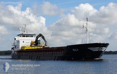
SULA
General Cargo
Current Trip
| Time Travelled | 2 days |
|---|---|
| Remaining Time | 5 h, 52 mins |
| Distance Travelled | 570.39 nm |
| Remaining Distance | 37.33 nm |
| AVG Speed | 9.5 Knots |
| MAX Speed | 13.8 Knots |
| AVG Wind | 19.8 knots |
| MAX Wind | 26 knots |
| MIN Temp | -2°C / 28.4°F |
| MAX Temp | 1.9°C / 35.42°F |
| Draught | 5.6 m |
| Position Received | 1 m ago |
Current Position
| Longitude | --- |
|---|---|
| Latitude | --- |
| Status | Under way using engine |
| Speed | 5 Knots |
| Course | 339.1° |
| Area | Skaggerak |
| Station | T-AIS |
| Position Received | 1 m ago |
Info
Information
The current position of SULA is in Skaggerak with coordinates 59.00266° / 10.62325° as reported on 2026-01-08 23:20 by AIS to our vessel tracker app. The vessel's current speed is 5 Knots and is heading at the port of KAMBO. The estimated time of arrival as calculated by MyShipTracking vessel tracking app is 2026-01-09 06:13 LT
The vessel SULA (IMO: 9006306, MMSI: 257115000) is a General Cargo that was built in 1992 ( 34 years old ). It's sailing under the flag of [NO] Norway.
In this page you can find informations about the vessels current position, last detected port calls, and current voyage information. If the vessels is not in coverage by AIS you will find the latest position.
The current position of SULA is detected by our AIS receivers and we are not responsible for the reliability of the data. The last position was recorded while the vessel was in Coverage by the Ais receivers of our vessel tracking app.
The current draught of SULA as reported by AIS is 5.6 meters
Weather
| Temperature | -0.5°C / 31.1°F |
|---|---|
| Wind Speed | 18 knots |
| Direction | 140° SE |
| Pressure | 1012.1 hPa |
| Humidity | 82.7 % |
| Cloud Coverage | 100 % |
Featured Company
Last Port Calls
| Port | Arrival | Departure | Time In Port |
|---|---|---|---|
| 2025-12-31 12:16 | 2026-01-06 11:52 | 5 d | |
| 2025-12-29 14:58 | 2025-12-30 16:33 | 1 d | |
| 2025-12-24 20:26 | 2025-12-24 21:47 | 1 h | |
| 2025-12-23 07:27 | 2025-12-24 10:14 | 1 d | |
| 2025-12-19 14:25 | 2025-12-20 12:27 | 22 h | |
| 2025-12-14 13:40 | 2025-12-16 18:02 | 2 d | |
| 2025-12-12 11:08 | 2025-12-13 10:19 | 23 h | |
| 2025-12-08 10:01 | 2025-12-08 11:11 | 1 h | |
| 2025-12-06 00:06 | 2025-12-08 00:32 | 2 d | |
| 2025-12-01 21:16 | 2025-12-02 13:39 | 16 h |
Last Trips
| Origin | Departure | Destination | Arrival | Distance | |
|---|---|---|---|---|---|
| 2025-12-30 16:33 | 2025-12-31 12:16 | 190.47 nm | |||
| 2025-12-24 21:47 | 2025-12-29 14:58 | 932.41 nm | |||
| 2025-12-24 10:14 | 2025-12-24 20:26 | 92.86 nm | |||
| 2025-12-20 12:27 | 2025-12-23 07:27 | 639.42 nm | |||
| 2025-12-16 18:02 | 2025-12-19 14:25 | 645.58 nm | |||
| 2025-12-13 10:19 | 2025-12-14 13:40 | 283.31 nm | |||
| 2025-12-08 11:11 | 2025-12-12 11:08 | 924.49 nm | |||
| 2025-12-08 00:32 | 2025-12-08 10:01 | 92.86 nm | |||
| 2025-12-02 13:39 | 2025-12-06 00:06 | 578.49 nm | |||
| 2025-11-25 19:30 | 2025-12-01 21:16 | 1101.75 nm |
Events
| Time | Event | Details | Position / Dest | Info |
|---|---|---|---|---|
| 2026-01-08 22:11 | Change Sea Area | Norwegian part of the Skaggerak Swedish part of the Skaggerak |
58.90711 / 10.68709
Skaggerak
NOKMO
|
Speed: 7.2 kn Course: 349.6° |
| 2026-01-08 14:35 | Detected in Sea | Swedish part of the Skaggerak |
57.86792 / 11.24567
Skaggerak
NOKMO
|
Speed: 10.1 kn Course: 346.8° |
| 2026-01-08 03:41 | Change Sea Area | Swedish part of the Kattegat Danish part of the Kattegat |
56.12984 / 12.52609
Kattegat
NOKMO
|
Speed: 13.7 kn Course: 318.1° |
| 2026-01-08 03:32 | Change Sea Area | Danish part of the Kattegat Swedish part of the Kattegat |
56.10463 / 12.56822
Kattegat
NOKMO
|
Speed: 13.8 kn Course: 314.4° |
| 2026-01-08 01:59 | Change Sea Area | Swedish part of the Kattegat Danish part of the Kattegat |
55.82938 / 12.72174
Kattegat
NOKMO
|
Speed: 11 kn Course: 7.8° |
| 2026-01-08 00:17 | Change Sea Area | Danish part of the Kattegat Swedish part of the Kattegat |
55.52056 / 12.72274
Kattegat
NOKMO
|
Speed: 10.6 kn Course: 4.3° |
| 2026-01-07 23:09 | Change Sea Area | Swedish part of the Kattegat Swedish part of the Baltic Sea |
55.33440 / 12.66877
Kattegat
NOKMO
|
Speed: 9.1 kn Course: 10° |
| 2026-01-07 19:01 | Status Changed | Under way using engine Default |
55.24678 / 13.57909
NOKMO
|
Speed: 8.3 kn Course: 272° |
| 2026-01-07 18:57 | Status Changed | Default Under way using engine |
55.24630 / 13.59736
NOKMO
|
Speed: 8.7 kn Course: 272.1° |
| 2026-01-07 13:22 | Detected in Sea | Swedish part of the Baltic Sea |
55.51098 / 14.76051
Baltic Sea
NOKMO
|
Speed: 9.2 kn Course: 239.8° |