
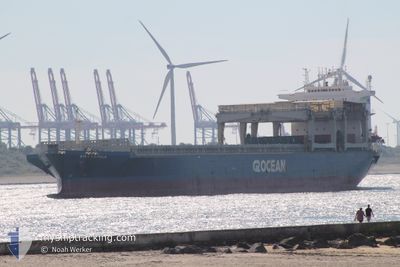
STAR HERDLA
General Cargo
Current Trip
| Time Travelled | 2 days |
|---|---|
| Remaining Time | --- |
| Distance Travelled | 503.66 nm |
| Remaining Distance | --- |
| AVG Speed | 10.1 Knots |
| MAX Speed | 12.7 Knots |
| AVG Wind | 6.9 knots |
| MAX Wind | 13 knots |
| MIN Temp | 8°C / 46.4°F |
| MAX Temp | 15.3°C / 59.54°F |
| Draught | 9.8 m |
| Position Received | 1 d ago |
Current Position
| Longitude | --- |
|---|---|
| Latitude | --- |
| Status | Under way using engine |
| Speed | 10.1 Knots |
| Course | 266.6° |
| Area | North Atlantic Ocean |
| Station | T-AIS |
| Position Received | 1 d ago |
Info
Information
The current position of STAR HERDLA is in North Atlantic Ocean with coordinates 43.94849° / -7.86579° as reported on 2024-12-13 21:51 by AIS to our vessel tracker app. The vessel's current speed is 10.1 Knots and is heading at the port of SANTOS. The estimated time of arrival as calculated by MyShipTracking vessel tracking app is 2025-01-02 22:00 LT
The vessel STAR HERDLA (IMO: 9071557, MMSI: 258954000) is a General Cargo that was built in 1994 ( 30 years old ). It's sailing under the flag of [NO] Norway.
In this page you can find informations about the vessels current position, last detected port calls, and current voyage information. If the vessels is not in coverage by AIS you will find the latest position.
The current position of STAR HERDLA is detected by our AIS receivers and we are not responsible for the reliability of the data. The last position was recorded while the vessel was in Coverage by the Ais receivers of our vessel tracking app.
The current draught of STAR HERDLA as reported by AIS is 9.8 meters
Weather
| Temperature | 15.3°C / 59.54°F |
|---|---|
| Wind Speed | 12 knots |
| Direction | 84° E |
| Pressure | 1032.6 hPa |
| Humidity | 70.8 % |
| Cloud Coverage | 99 % |
Featured Company
Last Port Calls
| Port | Arrival | Departure | Time In Port |
|---|---|---|---|
| 2024-12-04 02:31 | 2024-12-13 04:15 | 9 d | |
| 2024-11-25 05:24 | 2024-11-28 10:48 | 3 d | |
| 2024-11-20 03:45 | 2024-11-21 19:18 | 1 d | |
| 2024-11-11 08:09 | 2024-11-14 16:02 | 3 d | |
| 2024-10-10 10:42 | 2024-10-15 03:09 | 4 d | |
| 2024-10-01 11:19 |
Most Visited Ports (Last year)
| Port | Arrivals | |
|---|---|---|
| 2 | ||
| 2 | ||
| 1 | ||
| 1 | ||
| 1 | ||
| 1 |
Last Trips
| Origin | Departure | Destination | Arrival | Distance | |
|---|---|---|---|---|---|
| 2024-11-28 10:48 | 2024-12-04 02:31 | 760.00 nm | |||
| 2024-11-21 19:18 | 2024-11-25 05:24 | 347.32 nm | |||
| 2024-11-14 16:02 | 2024-11-20 03:45 | 1022.51 nm | |||
| 2024-10-15 03:09 | 2024-11-11 08:09 | 8221.31 nm | |||
| 2024-10-01 11:19 | 2024-10-10 10:42 | 2218.50 nm |
Events
| Time | Event | Details | Position / Dest | Info |
|---|---|---|---|---|
| 2024-12-13 22:02 | Status Changed | Default Under way using engine |
43.94711 / -7.90873
BRSSZ
|
Speed: 10.1 kn Course: 266.6° |
| 2024-12-13 21:51 | Status Changed | Under way using engine Default |
43.94849 / -7.86579
BRSSZ
|
Speed: 10.2 kn Course: 268° |
| 2024-12-13 21:51 | OUT of Coverage |
43.94849 / -7.86579
North Atlantic Ocean
BRSSZ
|
Speed: 10.1 kn Course: 266.6° |
|
| 2024-12-13 21:40 | Status Changed | Default Under way using engine |
43.95055 / -7.82304
BRSSZ
|
Speed: 10 kn Course: 265.2° |
| 2024-12-13 21:27 | Detected in Sea | Spanish part of the North Atlantic Ocean |
43.95377 / -7.77262
North Atlantic Ocean
BRSSZ
|
Speed: 10 kn Course: 265.4° |
| 2024-12-13 21:27 | Status Changed | Under way using engine Default |
43.95377 / -7.77262
BRSSZ
|
Speed: 9.7 kn Course: 262° |
| 2024-12-13 21:11 | IN Coverage |
43.95377 / -7.77262
North Atlantic Ocean
BRSSZ
|
Speed: 10 kn Course: 265.4° |
|
| 2024-12-13 13:47 | Status Changed | Default Under way using engine |
43.83622 / -6.02146
BRSSZ
|
Speed: 10.5 kn Course: 277.4° |
| 2024-12-13 13:39 | Status Changed | Under way using engine Default |
43.83319 / -5.99029
BRSSZ
|
Speed: 10.4 kn Course: 278° |
| 2024-12-13 13:39 | OUT of Coverage |
43.83319 / -5.99029
Bay of Biscay
BRSSZ
|
Speed: 10.5 kn Course: 277.4° |