
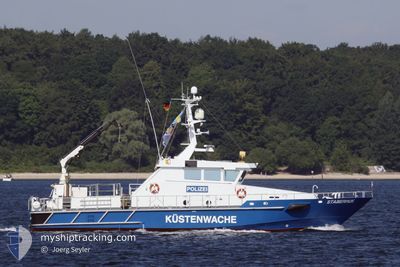
STABERHUK
Patrol Vessel
Current Trip
| Trip Time | 3 h, 25 mins |
|---|---|
| Trip Distance | 42.99 nm |
| AVG Speed | 13.8 Knots |
| MAX Speed | 17.6 Knots |
| Draught | 1.8 m |
| AVG Wind | 17.6 knots |
| MAX Wind | 19.3 knots |
| MIN Temp | 9.6°C / 49.28°F |
| MAX Temp | 9.9°C / 49.82°F |
| Position Received | 3 d ago |
Current Position
| Longitude | --- |
|---|---|
| Latitude | --- |
| Status | At anchor |
| Speed | 9.5 Knots |
| Course | 356.5° |
| Area | Baltic Sea |
| Station | T-AIS |
| Position Received | 3 d ago |
Info
Information
The current position of STABERHUK is in Baltic Sea with coordinates 54.46292° / 10.21763° as reported on 2025-12-07 15:15 by AIS to our vessel tracker app. The vessel's current speed is 9.5 Knots and is currently inside the port of FLENSBURG.
The vessel STABERHUK (IMO: 9452086, MMSI: 211462260) is a Patrol Vessel that was built in 2009 ( 16 years old ). It's sailing under the flag of [DE] Germany.
In this page you can find informations about the vessels current position, last detected port calls, and current voyage information. If the vessels is not in coverage by AIS you will find the latest position.
The current position of STABERHUK is detected by our AIS receivers and we are not responsible for the reliability of the data. The last position was recorded while the vessel was in Coverage by the Ais receivers of our vessel tracking app.
The current draught of STABERHUK as reported by AIS is 1.8 meters
Weather
| Temperature | 9.1°C / 48.38°F |
|---|---|
| Wind Speed | 15 knots |
| Direction | 247° WSW |
| Pressure | 1014.3 hPa |
| Humidity | 84.1 % |
| Cloud Coverage | 96 % |
Featured Company
Last Port Calls
| Port | Arrival | Departure | Time In Port |
|---|---|---|---|
| 2025-12-10 20:53 | |||
| 2025-12-07 17:58 | 2025-12-10 17:28 | 2 d | |
| 2025-12-06 16:25 | 2025-12-07 08:41 | 16 h | |
| 2025-12-06 11:27 | 2025-12-06 14:12 | 2 h | |
| 2025-12-06 10:39 | 2025-12-06 11:05 | 26 m | |
| 2025-12-02 17:58 | 2025-12-06 09:04 | 3 d | |
| 2025-12-02 10:11 | 2025-12-02 11:34 | 1 h | |
| 2025-12-01 18:43 | 2025-12-02 08:21 | 13 h | |
| 2025-11-26 17:46 | 2025-12-01 09:11 | 4 d | |
| 2025-11-26 08:19 | 2025-11-26 16:34 | 8 h |
Most Visited Ports (Last year)
| Port | Arrivals | |
|---|---|---|
| 115 | ||
| 60 | ||
| 30 | ||
| 21 | ||
| 9 | ||
| 6 |
Last Trips
| Origin | Departure | Destination | Arrival | Distance | |
|---|---|---|---|---|---|
| 2025-12-10 17:28 | 2025-12-10 20:53 | 42.99 nm | |||
| 2025-12-07 08:41 | 2025-12-07 17:58 | 58.35 nm | |||
| 2025-12-06 14:12 | 2025-12-06 16:25 | 34.59 nm | |||
| 2025-12-06 11:05 | 2025-12-06 11:27 | 3.25 nm | |||
| 2025-12-06 09:04 | 2025-12-06 10:39 | 16.51 nm | |||
| 2025-12-02 11:34 | 2025-12-02 17:58 | 40.84 nm | |||
| 2025-12-02 08:21 | 2025-12-02 10:11 | 18.95 nm | |||
| 2025-12-01 09:11 | 2025-12-01 18:43 | 65.27 nm | |||
| 2025-11-26 16:34 | 2025-11-26 17:46 | 19.37 nm | |||
| 2025-11-26 06:47 | 2025-11-26 08:19 | 17.99 nm |
Events
| Time | Event | Details | Position / Dest | Info |
|---|---|---|---|---|
| 2025-12-10 20:05 | STOP Moving |
54.79507 / 9.43328
[DE] FLENSBURG
|
Speed: Course: 342° |
|
| 2025-12-10 19:53 | PORT ARRIVAL |
|
54.80580 / 9.43964
[DE] FLENSBURG
|
Speed: 10.4 kn Course: 203° |
| 2025-12-10 16:47 | START Moving | 4.94 nm, North East of ECKERNFOERDE |
54.50047 / 9.98373
DE KIE
|
Speed: 14 kn Course: 57° |
| 2025-12-10 16:28 | PORT DEPARTURE |
|
54.50047 / 9.98373
DE KIE
|
Speed: Course: -1° |
| 2025-12-07 17:22 | STOP Moving |
54.47167 / 9.86500
[DE] ECKERNFOERDE
|
Speed: Course: -1° |
|
| 2025-12-07 16:58 | PORT ARRIVAL |
|
54.46925 / 9.85998
[DE] ECKERNFOERDE
|
Speed: 7 kn Course: 254° |
| 2025-12-07 15:19 | Status Changed | Default At anchor |
54.47212 / 10.20830
DE KIE
|
Speed: 9.5 kn Course: 356.5° |
| 2025-12-07 15:15 | OUT of Coverage |
54.46292 / 10.21763
Baltic Sea
DE KIE
|
Speed: 9.5 kn Course: 356.5° |
|
| 2025-12-07 14:31 | START Moving | 0.35 nm, South West of MOELTENORT |
54.37187 / 10.18725
DE KIE
|
Speed: 3.9 kn Course: 323° |
| 2025-12-07 14:06 | Status Changed | At anchor Default |
54.37026 / 10.18673
DE KIE
|
Speed: 0.3 kn Course: 220° |