
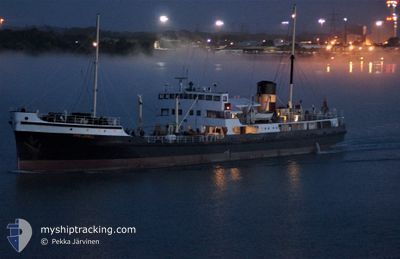
SS SHIELDHALL
Exhibition Ship
Current Trip
| Trip Time | 1 day |
|---|---|
| Trip Distance | 169.97 nm |
| AVG Speed | 6.9 Knots |
| MAX Speed | 11.4 Knots |
| Draught | 3.3 m |
| AVG Wind | 8.6 knots |
| MAX Wind | 15.8 knots |
| MIN Temp | 8°C / 46.4°F |
| MAX Temp | 10.7°C / 51.26°F |
| Position Received | 8 h, 30 m ago |
Current Position
| Longitude | -1.44186° |
|---|---|
| Latitude | 50.90796° |
| Status | Moored |
| Speed | |
| Course | --- |
| Area | English Channel |
| Station | T-AIS |
| Position Received | 8 h, 30 m ago |
Info
Information
The current position of SS SHIELDHALL is in English Channel with coordinates 50.90796° / -1.44186° as reported on 2024-04-26 12:31 by AIS to our vessel tracker app. The vessel's current speed is 0 Knots and is currently inside the port of SOUTHAMPTON.
The vessel SS SHIELDHALL (IMO: 5322752, MMSI: 232003964) is a Exhibition Ship that was built in 1955 ( 69 years old ). It's sailing under the flag of [GB] United Kingdom.
In this page you can find informations about the vessels current position, last detected port calls, and current voyage information. If the vessels is not in coverage by AIS you will find the latest position.
The current position of SS SHIELDHALL is detected by our AIS receivers and we are not responsible for the reliability of the data. The last position was recorded while the vessel was in Coverage by the Ais receivers of our vessel tracking app.
The current draught of SS SHIELDHALL as reported by AIS is 3.3 meters
Weather
| Temperature | 10.9°C / 51.62°F |
|---|---|
| Wind Speed | 8 knots |
| Direction | 86° E |
| Pressure | 1002.7 hPa |
| Humidity | 64.7 % |
| Cloud Coverage | 96 % |
Featured Company
Last Port Calls
| Port | Arrival | Departure | Time In Port |
|---|---|---|---|
| 2024-04-25 18:50 | |||
| 2024-04-24 15:02 | |||
| 2024-03-23 13:55 | 2024-04-18 06:55 | 25 d | |
| 2024-03-23 12:04 |
Most Visited Ports (Last year)
| Port | Arrivals | |
|---|---|---|
| 23 | ||
| 5 | ||
| 1 | ||
| 1 |
Last Trips
| Origin | Departure | Destination | Arrival | Distance | |
|---|---|---|---|---|---|
| 2024-04-24 16:02 | 2024-04-25 19:50 | 169.97 nm | |||
| 2024-03-23 12:04 | 2024-03-23 13:55 | 8.20 nm |
Events
| Time | Event | Details | Position / Dest | Info |
|---|---|---|---|---|
| 2024-04-26 12:31 | OUT of Coverage |
50.90796 / -1.44186
English Channel
[GB] SOUTHAMPTON
|
Speed: Course: 0° |
|
| 2024-04-26 12:31 | IN Coverage |
50.90796 / -1.44186
English Channel
[GB] SOUTHAMPTON
|
Speed: Course: 0° |
|
| 2024-04-25 19:39 | OUT of Coverage |
50.90783 / -1.44183
English Channel
[GB] SOUTHAMPTON
|
Speed: 0.2 kn Course: 345.3° |
|
| 2024-04-25 19:38 | Status Changed | Moored Under way using engine |
50.90783 / -1.44183
[GB] SOUTHAMPTON
|
Speed: 0.1 kn Course: 301° |
| 2024-04-25 19:32 | STOP Moving |
50.90767 / -1.44167
[GB] SOUTHAMPTON
|
Speed: 0.3 kn Course: 320° |
|
| 2024-04-25 18:50 | PORT ARRIVAL |
|
50.87183 / -1.37717
[GB] SOUTHAMPTON
|
Speed: 8.1 kn Course: 310.6° |
| 2024-04-25 15:09 | START Moving | 6.83 nm, South East of CHRISTCHURCH |
50.62783 / -1.65083
GB SOU
|
Speed: 3.1 kn Course: 336° |
| 2024-04-25 13:58 | STOP Moving | 6.94 nm, South East of CHRISTCHURCH |
50.63100 / -1.63900
GB SOU
|
Speed: 0.3 kn Course: 85° |
| 2024-04-25 13:29 | START Moving | 7.11 nm, South East of CHRISTCHURCH |
50.61983 / -1.65717
GB SOU
|
Speed: 3.3 kn Course: 27° |
| 2024-04-25 13:00 | STOP Moving | 7.13 nm, South East of CHRISTCHURCH |
50.61867 / -1.65933
GB SOU
|
Speed: 0.2 kn Course: 139° |