
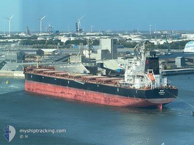
SIAN
Cargo
Current Trip
| Trip Time | 38 days |
|---|---|
| Trip Distance | 7970.46 nm |
| AVG Speed | 11 Knots |
| MAX Speed | 14 Knots |
| Draught | 13 m |
| AVG Wind | 8.3 knots |
| MAX Wind | 26.8 knots |
| MIN Temp | 13.7°C / 56.66°F |
| MAX Temp | 28.1°C / 82.58°F |
| Position Received | 5 d ago |
Current Position
| Longitude | --- |
|---|---|
| Latitude | --- |
| Status | Moored |
| Speed | |
| Course | 133° |
| Area | Persian Gulf |
| Station | T-AIS |
| Position Received | 5 d ago |
Info
Information
The current position of SIAN is in Persian Gulf with coordinates 30.43435° / 49.05642° as reported on 2025-12-07 21:32 by AIS to our vessel tracker app. The vessel's current speed is 0 Knots and is currently inside the port of BANDAR IMAM KHOMEINI.
The vessel SIAN (IMO: 9942639, MMSI: 636021210) is a Cargo It's sailing under the flag of [LR] Liberia.
In this page you can find informations about the vessels current position, last detected port calls, and current voyage information. If the vessels is not in coverage by AIS you will find the latest position.
The current position of SIAN is detected by our AIS receivers and we are not responsible for the reliability of the data. The last position was recorded while the vessel was in Coverage by the Ais receivers of our vessel tracking app.
The current draught of SIAN as reported by AIS is 13 meters
Weather
| Temperature | 15.9°C / 60.62°F |
|---|---|
| Wind Speed | 4 knots |
| Direction | 349° N |
| Pressure | 1016.5 hPa |
| Humidity | 52.9 % |
| Cloud Coverage | --- |
Featured Company
Last Port Calls
| Port | Arrival | Departure | Time In Port |
|---|---|---|---|
| 2025-12-04 22:41 | |||
| 2025-10-22 21:21 | 2025-10-27 12:21 | 4 d |
Most Visited Ports (Last year)
| Port | Arrivals | |
|---|---|---|
| 2 | ||
| 2 | ||
| 1 | ||
| 1 | ||
| 1 |
Last Trips
| Origin | Departure | Destination | Arrival | Distance | |
|---|---|---|---|---|---|
| 2025-10-27 12:21 | 2025-12-04 22:41 | 7970.46 nm | |||
| 2025-09-05 22:43 | 2025-10-22 21:21 | 10818.17 nm |
Events
| Time | Event | Details | Position / Dest | Info |
|---|---|---|---|---|
| 2025-12-07 21:35 | Status Changed | Default Moored |
30.43435 / 49.05642
[IR] BANDAR IMAM KHOMEINI
|
Speed: Course: 133° |
| 2025-12-07 21:32 | Status Changed | Moored Default |
30.43435 / 49.05642
[IR] BANDAR IMAM KHOMEINI
|
Speed: Course: 133° |
| 2025-12-07 21:32 | OUT of Coverage |
30.43435 / 49.05642
Persian Gulf
[IR] BANDAR IMAM KHOMEINI
|
Speed: Course: 25.2° |
|
| 2025-12-07 21:14 | IN Coverage |
30.43435 / 49.05642
Persian Gulf
[IR] BANDAR IMAM KHOMEINI
|
Speed: Course: 25.2° |
|
| 2025-12-04 19:12 | STOP Moving |
30.43424 / 49.05613
[IR] BANDAR IMAM KHOMEINI
|
Speed: 0.2 kn Course: 131° |
|
| 2025-12-04 19:11 | PORT ARRIVAL |
|
30.43424 / 49.05613
[IR] BANDAR IMAM KHOMEINI
|
Speed: 1.9 kn Course: 90° |
| 2025-12-04 12:42 | Status Changed | Default Under way using engine |
29.70524 / 49.47956
IR BKM
|
Speed: 9.1 kn Course: 252° |
| 2025-12-04 12:36 | Status Changed | Under way using engine Default |
29.70482 / 49.49893
IR BKM
|
Speed: 9.1 kn Course: 253° |
| 2025-12-04 12:36 | OUT of Coverage |
29.70482 / 49.49893
Persian Gulf
|
Speed: 9.1 kn Course: 252° |
|
| 2025-12-04 12:23 | Status Changed | Default Under way using engine |
29.71376 / 49.53246
IR BKM
|
Speed: 9.1 kn Course: 252° |