
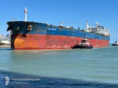
SFL THELON
Tanker
Current Trip
NGQIB
| Time Travelled | 37 days |
|---|---|
| Remaining Time | --- |
| Distance Travelled | 6650.98 nm |
| Remaining Distance | --- |
| AVG Speed | 11.1 Knots |
| MAX Speed | 15.1 Knots |
| AVG Wind | 11.5 knots |
| MAX Wind | 23.8 knots |
| MIN Temp | 7.7°C / 45.86°F |
| MAX Temp | 26.1°C / 78.98°F |
| Draught | 8.5 m |
| Position Received | 1 d ago |
Current Position
| Longitude | -50.94871° |
|---|---|
| Latitude | 43.78799° |
| Status | Under way using engine |
| Speed | 11.2 Knots |
| Course | 316.3° |
| Area | North Atlantic Ocean |
| Station | T-AIS |
| Position Received | 1 d ago |
Info
Information
The current position of SFL THELON is in North Atlantic Ocean with coordinates 43.78799° / -50.94871° as reported on 2024-06-15 21:56 by AIS to our vessel tracker app. The vessel's current speed is 11.2 Knots
The vessel SFL THELON (IMO: 9593000, MMSI: 538010172) is a Tanker It's sailing under the flag of [MH] Marshall Is.
In this page you can find informations about the vessels current position, last detected port calls, and current voyage information. If the vessels is not in coverage by AIS you will find the latest position.
The current position of SFL THELON is detected by our AIS receivers and we are not responsible for the reliability of the data. The last position was recorded while the vessel was in Coverage by the Ais receivers of our vessel tracking app.
The current draught of SFL THELON as reported by AIS is 8.5 meters
Weather
| Temperature | 12.8°C / 55.04°F |
|---|---|
| Wind Speed | 5 knots |
| Direction | 240° WSW |
| Pressure | 1020.6 hPa |
| Humidity | 69.2 % |
| Cloud Coverage | 20 % |
Featured Company
Last Port Calls
| Port | Arrival | Departure | Time In Port |
|---|---|---|---|
| 2024-05-10 00:37 | 2024-05-11 04:41 | 1 d | |
| 2024-05-04 04:00 | 2024-05-05 17:10 | 1 d | |
| 2024-05-02 10:39 | 2024-05-04 00:40 | 1 d |
Most Visited Ports (Last year)
| Port | Arrivals | |
|---|---|---|
| 2 | ||
| 2 | ||
| 1 | ||
| 1 | ||
| 1 | ||
| 1 |
Last Trips
| Origin | Departure | Destination | Arrival | Distance | |
|---|---|---|---|---|---|
| 2024-05-05 19:10 | 2024-05-10 02:37 | 714.02 nm | |||
| 2024-05-04 02:40 | 2024-05-04 06:00 | 22.56 nm | |||
| 2024-03-13 19:56 | 2024-05-02 12:39 | 6293.58 nm |
Events
| Time | Event | Details | Position / Dest | Info |
|---|---|---|---|---|
| 2024-06-17 03:27 | STOP Moving | 2.36 nm, South West of ARNOLD'S COVE |
47.72771 / -54.02321
NGQIB
|
Speed: 0.1 kn Course: 45° |
| 2024-06-15 22:04 | Status Changed | Default Under way using engine |
43.80667 / -50.97333
NGQIB
|
Speed: 11.2 kn Course: 316.3° |
| 2024-06-15 21:56 | OUT of Coverage |
43.78799 / -50.94872
North Atlantic Ocean
|
Speed: 11.2 kn Course: 316.3° |
|
| 2024-06-15 21:49 | Change Sea Area | Canadian part of the North Atlantic Ocean High seas of the North Atlantic Ocean |
43.77305 / -50.92921
North Atlantic Ocean
|
Speed: 11.3 kn Course: 316.4° |
| 2024-06-15 21:49 | Status Changed | Under way using engine Default |
43.77305 / -50.92921
NGQIB
|
Speed: 11 kn Course: 316° |
| 2024-06-15 21:37 | IN Coverage |
43.77305 / -50.92921
North Atlantic Ocean
|
Speed: 11.3 kn Course: 316.4° |
|
| 2024-06-15 19:13 | Status Changed | Default Under way using engine |
43.40833 / -50.47333
NGQIB
|
Speed: 10.9 kn Course: 317.8° |
| 2024-06-15 19:10 | OUT of Coverage |
43.40066 / -50.46496
North Atlantic Ocean
|
Speed: 10.9 kn Course: 317.8° |
|
| 2024-06-15 18:46 | Status Changed | Under way using engine Default |
43.34814 / -50.40131
NGQIB
|
Speed: 10 kn Course: 318° |
| 2024-06-15 18:37 | IN Coverage |
43.34814 / -50.40131
North Atlantic Ocean
|
Speed: 10.7 kn Course: 318.7° |