
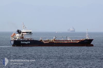
SEAVEN JOY
Oil/Chemical Tanker
Current Trip
ROSUL
| Time Travelled | 1 day |
|---|---|
| Remaining Time | --- |
| Distance Travelled | --- |
| Remaining Distance | --- |
| AVG Speed | --- |
| MAX Speed | --- |
| AVG Wind | --- |
| MAX Wind | --- |
| MIN Temp | --- |
| MAX Temp | --- |
| Draught | 6 m |
| Position Received | 3 d ago |
Current Position
| Longitude | --- |
|---|---|
| Latitude | --- |
| Status | Under way using engine |
| Speed | 9.8 Knots |
| Course | 8.9° |
| Area | Black Sea |
| Station | T-AIS |
| Position Received | 3 d ago |
Info
Information
The current position of SEAVEN JOY is in Black Sea with coordinates 41.46977° / 29.24911° as reported on 2025-12-12 06:04 by AIS to our vessel tracker app. The vessel's current speed is 9.8 Knots
The vessel SEAVEN JOY (IMO: 9539949, MMSI: 241523000) is a Oil/Chemical Tanker that was built in 2010 ( 15 years old ). It's sailing under the flag of [GR] Greece.
In this page you can find informations about the vessels current position, last detected port calls, and current voyage information. If the vessels is not in coverage by AIS you will find the latest position.
The current position of SEAVEN JOY is detected by our AIS receivers and we are not responsible for the reliability of the data. The last position was recorded while the vessel was in Coverage by the Ais receivers of our vessel tracking app.
The current draught of SEAVEN JOY as reported by AIS is 6 meters
Weather
| Temperature | 3.2°C / 37.76°F |
|---|---|
| Wind Speed | 7 knots |
| Direction | 288° WNW |
| Pressure | 1027.3 hPa |
| Humidity | 77.9 % |
| Cloud Coverage | 41 % |
Featured Company
Last Port Calls
| Port | Arrival | Departure | Time In Port |
|---|---|---|---|
| 2025-12-14 10:05 | 2025-12-14 10:45 | 40 m | |
| 2025-11-29 18:40 | 2025-12-09 21:05 | 10 d | |
| 2025-11-28 13:52 | 2025-11-28 22:59 | 9 h | |
| 2025-11-26 08:27 | 2025-11-26 17:40 | 9 h | |
| 2025-11-24 14:58 | 2025-11-25 06:02 | 15 h | |
| 2025-11-23 20:28 | 2025-11-24 14:04 | 17 h | |
| 2025-11-22 08:05 | 2025-11-22 21:31 | 13 h | |
| 2025-11-21 09:06 | 2025-11-21 17:10 | 8 h | |
| 2025-11-19 20:23 | 2025-11-20 09:12 | 12 h | |
| 2025-11-19 12:12 | 2025-11-19 17:44 | 5 h |
Most Visited Ports (Last year)
| Port | Arrivals | |
|---|---|---|
| 54 | ||
| 26 | ||
| 13 | ||
| 10 | ||
| 5 | ||
| 3 |
Last Trips
| Origin | Departure | Destination | Arrival | Distance | |
|---|---|---|---|---|---|
| 2025-12-09 21:05 | 2025-12-14 10:05 | 657.32 nm | |||
| 2025-11-28 22:59 | 2025-11-29 18:40 | 208.09 nm | |||
| 2025-11-26 17:40 | 2025-11-28 13:52 | 4.19 nm | |||
| 2025-11-25 06:02 | 2025-11-26 08:27 | 180.43 nm | |||
| 2025-11-24 14:04 | 2025-11-24 14:58 | 3.72 nm | |||
| 2025-11-22 21:31 | 2025-11-23 20:28 | 182.78 nm | |||
| 2025-11-21 17:10 | 2025-11-22 08:05 | 2.62 nm | |||
| 2025-11-20 09:12 | 2025-11-21 09:06 | 193.29 nm | |||
| 2025-11-19 17:44 | 2025-11-19 20:23 | 3.33 nm | |||
| 2025-11-18 08:41 | 2025-11-19 12:12 | 275.41 nm |
Events
| Time | Event | Details | Position / Dest | Info |
|---|---|---|---|---|
| 2025-12-14 08:45 | PORT DEPARTURE |
|
45.17054 / 29.57381
ROSUL
|
Speed: 6.9 kn Course: 293° |
| 2025-12-14 08:05 | PORT ARRIVAL |
|
45.15905 / 29.67227
[RO] SULINA
|
Speed: 4.5 kn Course: 253° |
| 2025-12-14 07:56 | START Moving | 1.9 nm, East of SULINA |
45.16308 / 29.69177
ROSUL
|
Speed: 4.5 kn Course: 253° |
| 2025-12-13 06:16 | STOP Moving | 7.74 nm, East of SULINA |
45.14630 / 29.82938
ROSUL
|
Speed: 0.3 kn Course: 310° |
| 2025-12-12 06:21 | Status Changed | Default Under way using engine |
41.51572 / 29.25779
ROSUL
|
Speed: 9.8 kn Course: 8.9° |
| 2025-12-12 06:04 | OUT of Coverage |
41.46977 / 29.24911
Black Sea
ROSUL
|
Speed: 9.8 kn Course: 8.9° |
|
| 2025-12-12 04:35 | Change Sea Area | Turkish part of the Black Sea Turkish part of the Sea of Marmara |
41.23718 / 29.15626
Black Sea
ROSUL
|
Speed: 10 kn Course: 44° |
| 2025-12-12 01:29 | START Moving | 8.98 nm, South West of MALTEPE |
40.82130 / 28.97471
ROSUL
|
Speed: 3.2 kn Course: 37° |
| 2025-12-11 21:17 | ETA Changed | 2025/12/12 22:00 2025/12/12 06:30 |
40.81390 / 29.00220
ROSUL
|
Speed: 0.2 kn Course: 173° |
| 2025-12-11 21:06 | STOP Moving | 8.32 nm, South West of MALTEPE |
40.81435 / 29.00289
ROSUL
|
Speed: 0.3 kn Course: 171° |