
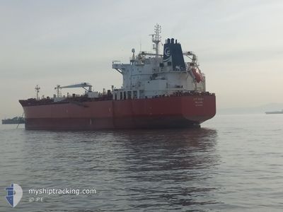
SEA QUEST
Oil/Chemical Tanker
Current Trip
| Time Travelled | 4 days |
|---|---|
| Remaining Time | 7 days |
| Distance Travelled | 1277.51 nm |
| Remaining Distance | 2069.65 nm |
| AVG Speed | 12 Knots |
| MAX Speed | 14.3 Knots |
| AVG Wind | 9.2 knots |
| MAX Wind | 14 knots |
| MIN Temp | 24°C / 75.2°F |
| MAX Temp | 27.6°C / 81.68°F |
| Draught | 12.3 m |
| Position Received | 4 d ago |
Current Position
| Longitude | --- |
|---|---|
| Latitude | --- |
| Status | Under way using engine |
| Speed | 12.4 Knots |
| Course | 143.1° |
| Area | Gulf of Oman |
| Station | T-AIS |
| Position Received | 4 d ago |
Info
Information
The current position of SEA QUEST is in Gulf of Oman with coordinates 24.74579° / 56.97272° as reported on 2025-12-09 05:00 by AIS to our vessel tracker app. The vessel's current speed is 12.4 Knots and is heading at the port of SINGAPORE. The estimated time of arrival as calculated by MyShipTracking vessel tracking app is 2025-12-20 21:32 LT
The vessel SEA QUEST (IMO: 9629940, MMSI: 538004535) is a Oil/Chemical Tanker that was built in 2012 ( 13 years old ). It's sailing under the flag of [MH] Marshall Is.
In this page you can find informations about the vessels current position, last detected port calls, and current voyage information. If the vessels is not in coverage by AIS you will find the latest position.
The current position of SEA QUEST is detected by our AIS receivers and we are not responsible for the reliability of the data. The last position was recorded while the vessel was in Coverage by the Ais receivers of our vessel tracking app.
The current draught of SEA QUEST as reported by AIS is 12.3 meters
Weather
| Temperature | 26.9°C / 80.42°F |
|---|---|
| Wind Speed | 5 knots |
| Direction | 40° NE |
| Pressure | 1009.9 hPa |
| Humidity | 64 % |
| Cloud Coverage | 12 % |
Featured Company
Events
| Time | Event | Details | Position / Dest | Info |
|---|---|---|---|---|
| 2025-12-09 05:04 | Status Changed | Default Under way using engine |
24.73333 / 56.98167
SGSIN
|
Speed: 12.4 kn Course: 143.1° |
| 2025-12-09 05:00 | OUT of Coverage |
24.74579 / 56.97272
Gulf of Oman
SGSIN
|
Speed: 12.4 kn Course: 143.1° |
|
| 2025-12-09 04:55 | Status Changed | Under way using engine Default |
24.75928 / 56.96166
SGSIN
|
Speed: 12.5 kn Course: 143° |
| 2025-12-09 04:40 | Status Changed | Default Under way using engine |
24.80050 / 56.92509
SGSIN
|
Speed: 12.5 kn Course: 139.6° |
| 2025-12-09 04:38 | Status Changed | Under way using engine Default |
24.80493 / 56.92096
SGSIN
|
Speed: 12.5 kn Course: 136° |
| 2025-12-09 04:29 | Status Changed | Default Under way using engine |
24.82987 / 56.89676
SGSIN
|
Speed: 12.5 kn Course: 135.9° |
| 2025-12-09 04:25 | Status Changed | Under way using engine Default |
24.83958 / 56.88645
SGSIN
|
Speed: 12.6 kn Course: 132° |
| 2025-12-09 04:11 | Status Changed | Default Under way using engine |
24.87303 / 56.84843
SGSIN
|
Speed: 12.6 kn Course: 132.8° |
| 2025-12-09 04:04 | Status Changed | Under way using engine Default |
24.88982 / 56.82851
SGSIN
|
Speed: 12.6 kn Course: 138° |
| 2025-12-09 04:01 | Status Changed | Default Under way using engine |
24.89820 / 56.81952
SGSIN
|
Speed: 12.7 kn Course: 137° |