
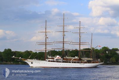
SEA CLOUD
Passengers Ship
Current Trip
| Time Travelled | 1 day |
|---|---|
| Remaining Time | --- |
| Distance Travelled | 109.02 nm |
| Remaining Distance | --- |
| AVG Speed | 8.2 Knots |
| MAX Speed | 9.4 Knots |
| AVG Wind | 12.1 knots |
| MAX Wind | 18 knots |
| MIN Temp | 25.2°C / 77.36°F |
| MAX Temp | 26.1°C / 78.98°F |
| Draught | 5.2 m |
| Position Received | 2 m ago |
Current Position
| Longitude | --- |
|---|---|
| Latitude | --- |
| Status | At anchor |
| Speed | |
| Course | 77° |
| Area | Caribbean Sea |
| Station | T-AIS |
| Position Received | 2 m ago |
Info
Information
The current position of SEA CLOUD is in Caribbean Sea with coordinates 18.31800° / -64.62867° as reported on 2025-03-04 16:19 by AIS to our vessel tracker app. The vessel's current speed is 0 Knots
The vessel SEA CLOUD (IMO: 8843446, MMSI: 256084000) is a Passengers Ship that was built in 1931 ( 94 years old ). It's sailing under the flag of [MT] Malta.
In this page you can find informations about the vessels current position, last detected port calls, and current voyage information. If the vessels is not in coverage by AIS you will find the latest position.
The current position of SEA CLOUD is detected by our AIS receivers and we are not responsible for the reliability of the data. The last position was recorded while the vessel was in Coverage by the Ais receivers of our vessel tracking app.
The current draught of SEA CLOUD as reported by AIS is 5.2 meters
Weather
| Temperature | 25.8°C / 78.44°F |
|---|---|
| Wind Speed | 10 knots |
| Direction | 94° E |
| Pressure | 1015.4 hPa |
| Humidity | 73.2 % |
| Cloud Coverage | 1 % |
Featured Company
Last Port Calls
| Port | Arrival | Departure | Time In Port |
|---|---|---|---|
| 2025-03-02 06:16 | 2025-03-02 19:15 | 12 h | |
| 2025-02-23 06:24 | 2025-02-23 21:30 | 15 h | |
| 2025-02-20 04:46 | 2025-02-20 14:03 | 9 h | |
| 2025-02-19 03:54 | 2025-02-19 13:08 | 9 h | |
| 2025-02-16 02:11 | 2025-02-16 21:01 | 18 h | |
| 2025-02-08 22:46 | 2025-02-09 20:05 | 21 h | |
| 2025-02-01 23:35 | 2025-02-02 21:21 | 21 h | |
| 2025-01-26 05:40 | 2025-01-26 22:27 | 16 h | |
| 2025-01-18 23:33 | 2025-01-19 21:56 | 22 h | |
| 2025-01-15 12:59 | 2025-01-15 18:13 | 5 h |
Most Visited Ports (Last year)
| Port | Arrivals | |
|---|---|---|
| 9 | ||
| 9 | ||
| 6 | ||
| 6 | ||
| 5 | ||
| 4 |
Last Trips
| Origin | Departure | Destination | Arrival | Distance | |
|---|---|---|---|---|---|
| 2025-02-23 21:30 | 2025-03-02 06:16 | 543.10 nm | |||
| 2025-02-20 14:03 | 2025-02-23 06:24 | 208.99 nm | |||
| 2025-02-19 13:08 | 2025-02-20 04:46 | 107.64 nm | |||
| 2025-02-16 21:01 | 2025-02-19 03:54 | 230.92 nm | |||
| 2025-02-09 20:05 | 2025-02-16 02:11 | 559.31 nm | |||
| 2025-02-02 21:21 | 2025-02-08 22:46 | 609.17 nm | |||
| 2025-01-26 22:27 | 2025-02-01 23:35 | 671.91 nm | |||
| 2025-01-19 21:56 | 2025-01-26 05:40 | 726.46 nm | |||
| 2025-01-15 18:13 | 2025-01-18 23:33 | 337.88 nm | |||
| 2025-01-10 23:16 | 2025-01-15 12:59 | 503.76 nm |
Events
| Time | Event | Details | Position / Dest | Info |
|---|---|---|---|---|
| 2025-03-04 13:21 | Status Changed | At anchor Default |
18.31818 / -64.62872
VIRGIN GORDA
|
Speed: Course: 106° |
| 2025-03-04 13:15 | Status Changed | Default At anchor |
18.31817 / -64.62873
VIRGIN GORDA
|
Speed: Course: 106° |
| 2025-03-04 12:28 | Status Changed | At anchor Under way using engine |
18.31800 / -64.62783
VIRGIN GORDA
|
Speed: 4 kn Course: 130° |
| 2025-03-04 12:28 | STOP Moving | 0.71 nm, West of NORMAN ISLAND |
18.31800 / -64.62783
VIRGIN GORDA
|
Speed: Course: 91° |
| 2025-03-04 10:34 | Status Changed | Under way using engine Default |
18.48400 / -64.43985
VIRGIN GORDA
|
Speed: 9.1 kn Course: 255° |
| 2025-03-04 10:34 | IN Coverage |
18.48400 / -64.43985
Caribbean Sea
|
Speed: 9 kn Course: 213° |
|
| 2025-03-04 10:09 | START Moving | 5 nm, North East of VIRGIN GORDA |
18.52367 / -64.39550
VIRGIN GORDA
|
Speed: 9.1 kn Course: 255° |
| 2025-03-03 21:57 | OUT of Coverage |
18.49750 / -64.37334
Caribbean Sea
|
Speed: Course: 165.2° |
|
| 2025-03-03 18:39 | IN Coverage |
18.49767 / -64.37350
Caribbean Sea
VIRGIN GORDA
|
Speed: Course: 93.7° |
|
| 2025-03-03 16:04 | OUT of Coverage |
18.51100 / -64.28134
Caribbean Sea
VIRGIN GORDA
|
Speed: 7.7 kn Course: 306.7° |