
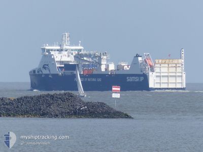
SAMSKIP KVITNOS
Cargo
Current Trip
| Time Travelled | 1 day |
|---|---|
| Remaining Time | 6 h, 33 mins |
| Distance Travelled | 387.05 nm |
| Remaining Distance | 90.29 nm |
| AVG Speed | 13.1 Knots |
| MAX Speed | 15.2 Knots |
| AVG Wind | 13.8 knots |
| MAX Wind | 28.8 knots |
| MIN Temp | 8.4°C / 47.12°F |
| MAX Temp | 11.3°C / 52.34°F |
| Draught | 5.1 m |
| Position Received | 2 m ago |
Current Position
| Longitude | --- |
|---|---|
| Latitude | --- |
| Status | Under way using engine |
| Speed | 13.6 Knots |
| Course | 19.9° |
| Area | North Sea |
| Station | T-AIS |
| Position Received | 2 m ago |
Info
Information
The current position of SAMSKIP KVITNOS is in North Sea with coordinates 57.95729° / 4.82754° as reported on 2025-12-13 21:01 by AIS to our vessel tracker app. The vessel's current speed is 13.6 Knots and is heading at the port of SANDNES. The estimated time of arrival as calculated by MyShipTracking vessel tracking app is 2025-12-14 04:37 LT
The vessel SAMSKIP KVITNOS (IMO: 9642576, MMSI: 259113000) is a Cargo It's sailing under the flag of [NO] Norway.
In this page you can find informations about the vessels current position, last detected port calls, and current voyage information. If the vessels is not in coverage by AIS you will find the latest position.
The current position of SAMSKIP KVITNOS is detected by our AIS receivers and we are not responsible for the reliability of the data. The last position was recorded while the vessel was in Coverage by the Ais receivers of our vessel tracking app.
The current draught of SAMSKIP KVITNOS as reported by AIS is 5.1 meters
Weather
| Temperature | 8.8°C / 47.84°F |
|---|---|
| Wind Speed | 29 knots |
| Direction | 211° SSW |
| Pressure | 1011.4 hPa |
| Humidity | 88.1 % |
| Cloud Coverage | 100 % |
Featured Company
Last Port Calls
| Port | Arrival | Departure | Time In Port |
|---|---|---|---|
| 2025-12-11 18:57 | 2025-12-12 17:31 | 22 h | |
| 2025-12-11 11:04 | 2025-12-11 17:22 | 6 h | |
| 2025-12-11 00:08 | 2025-12-11 09:18 | 9 h | |
| 2025-12-10 16:32 | 2025-12-10 17:47 | 1 h | |
| 2025-12-10 03:37 | 2025-12-10 16:12 | 12 h | |
| 2025-12-08 07:49 | 2025-12-08 11:07 | 3 h | |
| 2025-12-05 11:07 | 2025-12-07 07:03 | 1 d | |
| 2025-12-04 13:42 | 2025-12-04 15:06 | 1 h | |
| 2025-12-04 08:43 | 2025-12-04 13:33 | 4 h | |
| 2025-12-04 01:26 | 2025-12-04 06:06 | 4 h |
Most Visited Ports (Last year)
| Port | Arrivals | |
|---|---|---|
| 32 | ||
| 29 | ||
| 28 | ||
| 23 | ||
| 20 | ||
| 19 |
Last Trips
| Origin | Departure | Destination | Arrival | Distance | |
|---|---|---|---|---|---|
| 2025-12-11 17:22 | 2025-12-11 18:57 | 15.87 nm | |||
| 2025-12-11 09:18 | 2025-12-11 11:04 | 16.72 nm | |||
| 2025-12-10 17:47 | 2025-12-11 00:08 | 74.86 nm | |||
| 2025-12-10 16:12 | 2025-12-10 16:32 | 1.53 nm | |||
| 2025-12-08 11:07 | 2025-12-10 03:37 | 421.68 nm | |||
| 2025-12-07 07:03 | 2025-12-08 07:49 | 232.92 nm | |||
| 2025-12-04 15:06 | 2025-12-05 11:07 | 259.87 nm | |||
| 2025-12-04 13:33 | 2025-12-04 13:42 | 0.95 nm | |||
| 2025-12-04 06:06 | 2025-12-04 08:43 | 6.40 nm | |||
| 2025-12-02 08:46 | 2025-12-04 01:26 | 476.63 nm |
Events
| Time | Event | Details | Position / Dest | Info |
|---|---|---|---|---|
| 2025-12-13 20:29 | Status Changed | Under way using engine Default |
57.84260 / 4.75140
SANDNES
|
Speed: 13 kn Course: 18° |
| 2025-12-13 20:23 | Status Changed | Default Under way using engine |
57.82333 / 4.73833
SANDNES
|
Speed: 13.2 kn Course: 20.5° |
| 2025-12-13 20:20 | Status Changed | Under way using engine Default |
57.81202 / 4.73075
SANDNES
|
Speed: 13.2 kn Course: 22° |
| 2025-12-13 20:20 | IN Coverage |
57.81202 / 4.73075
North Sea
SANDNES
|
Speed: 13.2 kn Course: 20.5° |
|
| 2025-12-13 20:20 | Detected in Sea | Norwegian part of the North Sea |
57.81202 / 4.73075
North Sea
SANDNES
|
Speed: 13.2 kn Course: 20.5° |
| 2025-12-12 20:46 | Status Changed | Default Under way using engine |
52.66143 / 3.73500
SANDNES
|
Speed: 14.1 kn Course: 323° |
| 2025-12-12 20:42 | OUT of Coverage |
52.64949 / 3.74998
North Sea
SANDNES
|
Speed: 14.1 kn Course: 323° |
|
| 2025-12-12 20:40 | Status Changed | Under way using engine Default |
52.64293 / 3.75818
SANDNES
|
Speed: 14.3 kn Course: 323° |
| 2025-12-12 20:40 | IN Coverage |
52.64949 / 3.74998
North Sea
SANDNES
|
Speed: 14.1 kn Course: 323° |
|
| 2025-12-12 19:30 | OUT of Coverage |
52.38649 / 3.86924
North Sea
SANDNES
|
Speed: 15 kn Course: 7.8° |