
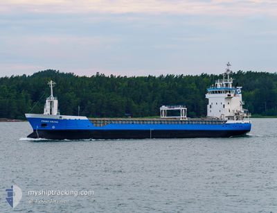
PRIMA VIKING
General Cargo
Current Trip
| Trip Time | 11 h, 27 mins |
|---|---|
| Trip Distance | 25.60 nm |
| AVG Speed | 7.4 Knots |
| MAX Speed | 11.7 Knots |
| Draught | 3.4 m |
| AVG Wind | 3.2 knots |
| MAX Wind | 5 knots |
| MIN Temp | 10.4°C / 50.72°F |
| MAX Temp | 12.8°C / 55.04°F |
| Position Received | 4 m ago |
Current Position
| Longitude | -6.30485° |
|---|---|
| Latitude | 53.72083° |
| Status | Moored |
| Speed | |
| Course | 88° |
| Area | Irish Sea and St. George's Channel |
| Station | T-AIS |
| Position Received | 4 m ago |
Info
Information
The current position of PRIMA VIKING is in Irish Sea and St. George's Channel with coordinates 53.72083° / -6.30485° as reported on 2024-05-08 03:48 by AIS to our vessel tracker app. The vessel's current speed is 0 Knots and is currently inside the port of DROGHEDA.
The vessel PRIMA VIKING (IMO: 9195810, MMSI: 230011000) is a General Cargo that was built in 1999 ( 25 years old ). It's sailing under the flag of [FI] Finland.
In this page you can find informations about the vessels current position, last detected port calls, and current voyage information. If the vessels is not in coverage by AIS you will find the latest position.
The current position of PRIMA VIKING is detected by our AIS receivers and we are not responsible for the reliability of the data. The last position was recorded while the vessel was in Coverage by the Ais receivers of our vessel tracking app.
The current draught of PRIMA VIKING as reported by AIS is 3.4 meters
Weather
| Temperature | 11.6°C / 52.88°F |
|---|---|
| Wind Speed | 5 knots |
| Direction | 226° SW |
| Pressure | 1026.2 hPa |
| Humidity | 88.2 % |
| Cloud Coverage | 100 % |
Featured Company
Last Port Calls
| Port | Arrival | Departure | Time In Port |
|---|---|---|---|
| 2024-05-07 20:50 | |||
| 2024-05-05 20:31 | 2024-05-07 09:23 | 1 d | |
| 2024-05-04 14:34 | 2024-05-05 17:06 | 1 d | |
| 2024-05-03 02:37 | 2024-05-03 14:55 | 12 h | |
| 2024-04-22 19:40 | 2024-04-26 13:08 | 3 d | |
| 2024-04-17 04:24 | 2024-04-18 18:06 | 1 d | |
| 2024-04-14 10:25 | 2024-04-15 23:00 | 1 d | |
| 2024-04-12 06:38 | 2024-04-13 06:10 | 23 h | |
| 2024-04-11 01:56 | 2024-04-11 17:48 | 15 h | |
| 2024-04-08 02:35 | 2024-04-08 02:38 | 3 m |
Last Trips
| Origin | Departure | Destination | Arrival | Distance | |
|---|---|---|---|---|---|
| 2024-05-07 10:23 | 2024-05-07 21:50 | 25.60 nm | |||
| 2024-05-05 18:06 | 2024-05-05 21:31 | 24.16 nm | |||
| 2024-05-03 15:55 | 2024-05-04 15:34 | 252.15 nm | |||
| 2024-04-26 15:08 | 2024-05-03 03:37 | 1550.22 nm | |||
| 2024-04-18 20:06 | 2024-04-22 21:40 | 608.01 nm | |||
| 2024-04-16 02:00 | 2024-04-17 06:24 | 297.83 nm | |||
| 2024-04-13 09:10 | 2024-04-14 13:25 | 301.78 nm | |||
| 2024-04-11 20:48 | 2024-04-12 09:38 | 110.90 nm | |||
| 2024-04-08 04:38 | 2024-04-11 04:56 | 692.01 nm | |||
| 2024-04-07 16:00 | 2024-04-08 04:35 | 86.07 nm |
Events
| Time | Event | Details | Position / Dest | Info |
|---|---|---|---|---|
| 2024-05-07 23:18 | IN Coverage |
53.72082 / -6.30484
Irish Sea and St. George's Channel
[IE] DROGHEDA
|
Speed: Course: 257.9° |
|
| 2024-05-07 21:07 | Status Changed | Default Under way using engine |
53.72079 / -6.30476
[IE] DROGHEDA
|
Speed: 0.6 kn Course: 117° |
| 2024-05-07 21:07 | STOP Moving |
53.72079 / -6.30476
[IE] DROGHEDA
|
Speed: 0.1 kn Course: 86° |
|
| 2024-05-07 20:54 | OUT of Coverage |
53.72019 / -6.31006
Irish Sea and St. George's Channel
[IE] DROGHEDA
|
Speed: 0.6 kn Course: 225.4° |
|
| 2024-05-07 20:50 | PORT ARRIVAL |
|
53.72050 / -6.30746
[IE] DROGHEDA
|
Speed: 4.2 kn Course: 264° |
| 2024-05-07 20:09 | START Moving | 4.33 nm, South of CLOGHERHEAD |
53.72982 / -6.18492
IEDRO
|
Speed: 7.6 kn Course: 234.8° |
| 2024-05-07 20:06 | Status Changed | Under way using engine At anchor |
53.73288 / -6.18284
IEDRO
|
Speed: 3.2 kn Course: 127° |
| 2024-05-07 11:48 | Status Changed | At anchor Under way using engine |
53.73136 / -6.18322
IEDRO
|
Speed: 0.5 kn Course: 3° |
| 2024-05-07 11:46 | STOP Moving | 4.26 nm, South of CLOGHERHEAD |
53.73146 / -6.18329
IEDRO
|
Speed: 0.3 kn Course: 7° |
| 2024-05-07 09:23 | PORT DEPARTURE |
|
54.00702 / -6.33297
IEDRO
|
Speed: 6.1 kn Course: 123° |