
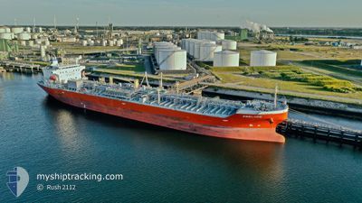
PRELUDE
Tanker
Current Trip
| Time Travelled | 1 day |
|---|---|
| Remaining Time | --- |
| Distance Travelled | 91.17 nm |
| Remaining Distance | 233.40 nm |
| AVG Speed | 12.4 Knots |
| MAX Speed | 12.7 Knots |
| AVG Wind | 9.8 knots |
| MAX Wind | 11 knots |
| MIN Temp | 24.1°C / 75.38°F |
| MAX Temp | 27.2°C / 80.96°F |
| Draught | 8.1 m |
| Position Received | 10 d ago |
Current Position
| Longitude | --- |
|---|---|
| Latitude | --- |
| Status | Under way using engine |
| Speed | 12.7 Knots |
| Course | 80.9° |
| Area | Singapore Strait |
| Station | T-AIS |
| Position Received | 10 d ago |
Info
Information
The current position of PRELUDE is in Singapore Strait with coordinates 1.27029° / 104.27362° as reported on 2025-12-12 10:40 by AIS to our vessel tracker app. The vessel's current speed is 12.7 Knots and is heading at the port of SURAT THANI. The estimated time of arrival as calculated by MyShipTracking vessel tracking app is 2025-12-15 06:00 LT
The vessel PRELUDE (IMO: 9810654, MMSI: 374788000) is a Tanker It's sailing under the flag of [PA] Panama.
In this page you can find informations about the vessels current position, last detected port calls, and current voyage information. If the vessels is not in coverage by AIS you will find the latest position.
The current position of PRELUDE is detected by our AIS receivers and we are not responsible for the reliability of the data. The last position was recorded while the vessel was in Coverage by the Ais receivers of our vessel tracking app.
The current draught of PRELUDE as reported by AIS is 8.1 meters
Weather
| Temperature | 26.5°C / 79.7°F |
|---|---|
| Wind Speed | 2 knots |
| Direction | 320° NW |
| Pressure | 1010.7 hPa |
| Humidity | 77.1 % |
| Cloud Coverage | 100 % |
Featured Company
Last Port Calls
| Port | Arrival | Departure | Time In Port |
|---|---|---|---|
| 2025-12-21 11:47 | 2025-12-22 03:50 | 16 h | |
| 2025-12-20 18:42 | 2025-12-21 08:22 | 13 h | |
| 2025-11-18 09:40 | 2025-11-30 18:29 | 12 d | |
| 2025-11-14 07:16 | 2025-11-15 03:34 | 20 h | |
| 2025-11-12 11:41 | 2025-11-14 05:45 | 1 d | |
| 2025-11-11 08:08 | 2025-11-12 06:22 | 22 h | |
| 2025-10-27 10:55 | 2025-10-27 23:26 | 12 h | |
| 2025-10-25 09:47 | 2025-10-27 10:04 | 2 d | |
| 2025-10-24 21:19 | 2025-10-25 08:36 | 11 h | |
| 2025-10-24 08:23 | 2025-10-24 20:22 | 11 h |
Most Visited Ports (Last year)
| Port | Arrivals | |
|---|---|---|
| 7 | ||
| 5 | ||
| 4 | ||
| 4 | ||
| 3 | ||
| 2 |
Last Trips
| Origin | Departure | Destination | Arrival | Distance | |
|---|---|---|---|---|---|
| 2025-12-21 08:22 | 2025-12-21 11:47 | 25.76 nm | |||
| 2025-11-30 18:29 | 2025-12-20 18:42 | 1327.83 nm | |||
| 2025-11-15 03:34 | 2025-11-18 09:40 | 552.98 nm | |||
| 2025-11-14 05:45 | 2025-11-14 07:16 | 11.27 nm | |||
| 2025-11-12 06:22 | 2025-11-12 11:41 | 19.10 nm | |||
| 2025-10-27 23:26 | 2025-11-11 08:08 | 3023.71 nm | |||
| 2025-10-27 10:04 | 2025-10-27 10:55 | 9.05 nm | |||
| 2025-10-25 08:36 | 2025-10-25 09:47 | 8.09 nm | |||
| 2025-10-24 20:22 | 2025-10-24 21:19 | 9.31 nm | |||
| 2025-09-14 03:38 | 2025-10-24 08:23 | 10116.79 nm |
Events
| Time | Event | Details | Position / Dest | Info |
|---|---|---|---|---|
| 2025-12-21 20:50 | PORT DEPARTURE |
|
12.63266 / 101.29799
TH URT
|
Speed: 3.7 kn Course: 218° |
| 2025-12-21 20:46 | START Moving |
12.63731 / 101.30078
[TH] RAYONG
|
Speed: 3.7 kn Course: 218° |
|
| 2025-12-21 05:06 | STOP Moving |
12.63980 / 101.30465
[TH] RAYONG
|
Speed: 0.1 kn Course: 204° |
|
| 2025-12-21 04:47 | PORT ARRIVAL |
|
12.63980 / 101.30465
[TH] RAYONG
|
Speed: 3.1 kn Course: 23° |
| 2025-12-21 01:22 | PORT DEPARTURE |
|
12.62516 / 101.15567
TH URT
|
Speed: 9.7 kn Course: 167° |
| 2025-12-21 01:06 | START Moving |
12.66248 / 101.14523
[TH] MAP TA PHUT
|
Speed: 5.8 kn Course: 149° |
|
| 2025-12-20 11:50 | STOP Moving |
12.66708 / 101.13969
[TH] MAP TA PHUT
|
Speed: 0.3 kn Course: 184° |
|
| 2025-12-20 11:42 | PORT ARRIVAL |
|
12.66620 / 101.14033
[TH] MAP TA PHUT
|
Speed: 2 kn Course: 262° |
| 2025-12-20 10:18 | START Moving | 6.47 nm, South East of MAP TA PHUT |
12.56874 / 101.21880
TH URT
|
Speed: 4.1 kn Course: 290° |
| 2025-12-20 02:38 | STOP Moving | 6.42 nm, South West of RAYONG |
12.56822 / 101.22196
TH URT
|
Speed: 0.2 kn Course: 80° |