
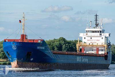
OSTBENSE
General Cargo
Current Trip
| Time Travelled | 11 days |
|---|---|
| Remaining Time | 1 day |
| Distance Travelled | 2617.89 nm |
| Remaining Distance | 517.20 nm |
| AVG Speed | 9.5 Knots |
| MAX Speed | 13 Knots |
| AVG Wind | 15.3 knots |
| MAX Wind | 34 knots |
| MIN Temp | 7.5°C / 45.5°F |
| MAX Temp | 17.5°C / 63.5°F |
| Draught | 6.4 m |
| Position Received | 2 d ago |
Current Position
| Longitude | --- |
|---|---|
| Latitude | --- |
| Status | Under way using engine |
| Speed | 10.5 Knots |
| Course | 358.7° |
| Area | North Atlantic Ocean |
| Station | T-AIS |
| Position Received | 2 d ago |
Info
Information
The current position of OSTBENSE is in North Atlantic Ocean with coordinates 39.19544° / -9.83931° as reported on 2026-01-01 14:31 by AIS to our vessel tracker app. The vessel's current speed is 10.5 Knots and is heading at the port of ANTWERP. The estimated time of arrival as calculated by MyShipTracking vessel tracking app is 2026-01-06 05:18 LT
The vessel OSTBENSE (IMO: 9566784, MMSI: 305631000) is a General Cargo that was built in 2011 ( 15 years old ). It's sailing under the flag of [AG] Antigua Barbuda.
In this page you can find informations about the vessels current position, last detected port calls, and current voyage information. If the vessels is not in coverage by AIS you will find the latest position.
The current position of OSTBENSE is detected by our AIS receivers and we are not responsible for the reliability of the data. The last position was recorded while the vessel was in Coverage by the Ais receivers of our vessel tracking app.
The current draught of OSTBENSE as reported by AIS is 6.4 meters
Weather
| Temperature | 7.3°C / 45.14°F |
|---|---|
| Wind Speed | 14 knots |
| Direction | 359° N |
| Pressure | 1018.5 hPa |
| Humidity | 62 % |
| Cloud Coverage | 100 % |
Featured Company
Last Port Calls
| Port | Arrival | Departure | Time In Port |
|---|---|---|---|
| 2025-12-21 18:54 | 2025-12-24 11:53 | 2 d | |
| 2025-12-19 18:14 | 2025-12-20 19:43 | 1 d | |
| 2025-12-16 11:31 | 2025-12-19 12:54 | 3 d | |
| 2025-12-09 07:15 | 2025-12-09 14:24 | 7 h | |
| 2025-11-29 18:38 | 2025-12-03 00:59 | 3 d | |
| 2025-11-21 16:39 | 2025-11-26 01:54 | 4 d | |
| 2025-11-20 14:23 |
Last Trips
| Origin | Departure | Destination | Arrival | Distance | |
|---|---|---|---|---|---|
| 2025-12-20 19:43 | 2025-12-21 18:54 | 280.82 nm | |||
| 2025-12-19 12:54 | 2025-12-19 18:14 | 58.08 nm | |||
| 2025-12-09 14:24 | 2025-12-16 11:31 | 1828.18 nm | |||
| 2025-12-03 00:59 | 2025-12-09 07:15 | 1490.05 nm | |||
| 2025-11-26 01:54 | 2025-11-29 18:38 | 792.08 nm | |||
| 2025-11-20 14:23 | 2025-11-21 16:39 | 301.34 nm |
Events
| Time | Event | Details | Position / Dest | Info |
|---|---|---|---|---|
| 2026-01-01 14:35 | Status Changed | Default Under way using engine |
39.20500 / -9.83833
BEANR
|
Speed: 10.5 kn Course: 358.7° |
| 2026-01-01 14:31 | OUT of Coverage |
39.19544 / -9.83931
North Atlantic Ocean
BEANR
|
Speed: 10.5 kn Course: 358.7° |
|
| 2026-01-01 13:59 | Status Changed | Under way using engine Default |
39.10383 / -9.83985
BEANR
|
Speed: 10.5 kn Course: 1° |
| 2026-01-01 13:47 | Status Changed | Default Under way using engine |
39.06929 / -9.84150
BEANR
|
Speed: 10.6 kn Course: 1.5° |
| 2026-01-01 12:35 | Status Changed | Under way using engine Default |
38.85902 / -9.84339
BEANR
|
Speed: 10.3 kn Course: 2° |
| 2026-01-01 12:31 | Status Changed | Default Under way using engine |
38.84740 / -9.84362
BEANR
|
Speed: 10.3 kn Course: 1.2° |
| 2026-01-01 12:29 | Status Changed | Under way using engine Default |
38.84161 / -9.84372
BEANR
|
Speed: 10.5 kn Course: 2° |
| 2026-01-01 12:19 | Status Changed | Default Under way using engine |
38.81167 / -9.84333
BEANR
|
Speed: 10.3 kn Course: 1.7° |
| 2026-01-01 12:07 | Status Changed | Under way using engine Default |
38.77788 / -9.84636
BEANR
|
Speed: 10.3 kn Course: 0° |
| 2026-01-01 12:05 | Status Changed | Default Under way using engine |
38.77220 / -9.84646
BEANR
|
Speed: 10.3 kn Course: 358.6° |