
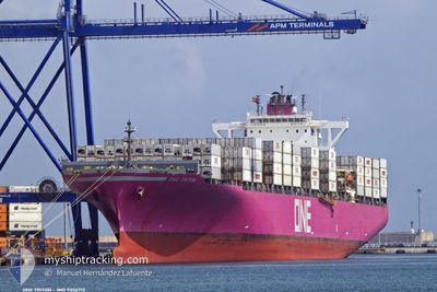
ONE TRITON
Container Ship
Current Trip
| Time Travelled | 2 days |
|---|---|
| Remaining Time | --- |
| Distance Travelled | 310.81 nm |
| Remaining Distance | 48.87 nm |
| AVG Speed | 12.4 Knots |
| MAX Speed | 19.4 Knots |
| AVG Wind | 9 knots |
| MAX Wind | 22.5 knots |
| MIN Temp | 4.7°C / 40.46°F |
| MAX Temp | 9.4°C / 48.92°F |
| Draught | 10.7 m |
| Position Received | 1 m ago |
Current Position
| Longitude | --- |
|---|---|
| Latitude | --- |
| Status | Under way using engine |
| Speed | 1.7 Knots |
| Course | 191° |
| Area | North Sea |
| Station | T-AIS |
| Position Received | 1 m ago |
Info
Information
The current position of ONE TRITON is in North Sea with coordinates 54.04335° / 7.41908° as reported on 2025-03-05 07:06 by AIS to our vessel tracker app. The vessel's current speed is 1.7 Knots and is heading at the port of BREMERHAVEN. The estimated time of arrival as calculated by MyShipTracking vessel tracking app is 2025-03-03 15:00 LT
The vessel ONE TRITON (IMO: 9356713, MMSI: 319219200) is a Container Ship that was built in 2008 ( 17 years old ). It's sailing under the flag of [KY] Cayman Is.
In this page you can find informations about the vessels current position, last detected port calls, and current voyage information. If the vessels is not in coverage by AIS you will find the latest position.
The current position of ONE TRITON is detected by our AIS receivers and we are not responsible for the reliability of the data. The last position was recorded while the vessel was in Coverage by the Ais receivers of our vessel tracking app.
The current draught of ONE TRITON as reported by AIS is 10.7 meters
Weather
| Temperature | 6°C / 42.8°F |
|---|---|
| Wind Speed | 22 knots |
| Direction | 235° SW |
| Pressure | 1019.9 hPa |
| Humidity | 81.4 % |
| Cloud Coverage | 90 % |
Featured Company
Last Port Calls
| Port | Arrival | Departure | Time In Port |
|---|---|---|---|
| 2025-03-01 18:55 | 2025-03-02 13:35 | 18 h | |
| 2025-02-26 07:46 | 2025-02-28 23:12 | 2 d | |
| 2025-02-18 17:34 | 2025-02-19 17:04 | 23 h | |
| 2025-02-16 23:30 | 2025-02-17 10:11 | 10 h | |
| 2025-02-01 04:11 | 2025-02-02 21:29 | 1 d | |
| 2025-01-25 20:25 | 2025-01-26 21:12 | 1 d | |
| 2025-01-01 08:51 | 2025-01-04 05:42 | 2 d |
Last Trips
| Origin | Departure | Destination | Arrival | Distance | |
|---|---|---|---|---|---|
| 2025-02-28 23:12 | 2025-03-01 18:55 | 242.73 nm | |||
| 2025-02-19 17:04 | 2025-02-26 07:46 | 266.96 nm | |||
| 2025-02-17 10:11 | 2025-02-18 17:34 | 403.23 nm | |||
| 2025-02-02 21:29 | 2025-02-16 23:30 | 5560.20 nm | |||
| 2025-01-26 21:12 | 2025-02-01 04:11 | 513.94 nm | |||
| 2025-01-04 05:42 | 2025-01-25 20:25 | 6508.08 nm | |||
| 2024-12-31 06:49 | 2025-01-01 08:51 | 397.04 nm |
Events
| Time | Event | Details | Position / Dest | Info |
|---|---|---|---|---|
| 2025-03-05 07:02 | Status Changed | Under way using engine At anchor |
54.04391 / 7.41934
BEANR>DEBRV
|
Speed: 0.1 kn Course: 207° |
| 2025-03-05 06:12 | ETA Changed | 2025/03/05 09:30 2025/03/03 14:00 |
54.04481 / 7.42179
BEANR>DEBRV
|
Speed: Course: 213° |
| 2025-03-05 04:50 | Status Changed | At anchor Default |
54.04463 / 7.42237
BEANR>DEBRV
|
Speed: Course: 233° |
| 2025-03-05 04:44 | Status Changed | Default At anchor |
54.04453 / 7.42249
BEANR>DEBRV
|
Speed: Course: 232° |
| 2025-03-04 21:23 | Status Changed | At anchor Default |
54.04386 / 7.42295
BEANR>DEBRV
|
Speed: 0.1 kn Course: 255° |
| 2025-03-04 21:20 | Status Changed | Default At anchor |
54.04397 / 7.42292
BEANR>DEBRV
|
Speed: 0.1 kn Course: 250° |
| 2025-03-04 17:50 | Status Changed | At anchor Default |
54.04514 / 7.42005
BEANR>DEBRV
|
Speed: Course: 191° |
| 2025-03-04 17:44 | Status Changed | Default At anchor |
54.04510 / 7.42031
BEANR>DEBRV
|
Speed: Course: 191° |
| 2025-03-04 17:35 | Status Changed | At anchor Default |
54.04501 / 7.42051
BEANR>DEBRV
|
Speed: Course: 194° |
| 2025-03-04 17:32 | Status Changed | Default At anchor |
54.04499 / 7.42053
BEANR>DEBRV
|
Speed: Course: 196° |