
NORDSOE
Fishing
Current Trip
| Trip Time | 2 days |
|---|---|
| Trip Distance | 295.47 nm |
| AVG Speed | 7 Knots |
| MAX Speed | 10.5 Knots |
| Draught | 5 m |
| AVG Wind | 14.5 knots |
| MAX Wind | 23.5 knots |
| MIN Temp | 7.4°C / 45.32°F |
| MAX Temp | 9.4°C / 48.92°F |
| Position Received | 2 m ago |
Current Position
| Longitude | --- |
|---|---|
| Latitude | --- |
| Status | Under way using engine |
| Speed | |
| Course | 11° |
| Area | Skaggerak |
| Station | T-AIS |
| Position Received | 2 m ago |
Info
Information
The current position of NORDSOE is in Skaggerak with coordinates 57.59255° / 9.95691° as reported on 2025-12-20 01:57 by AIS to our vessel tracker app. The vessel's current speed is 0 Knots and is currently inside the port of HIRTSHALS.
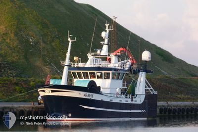
The vessel NORDSOE (IMO: 9841550, MMSI: 257070440) is a Fishing It's sailing under the flag of [NO] Norway.
In this page you can find informations about the vessels current position, last detected port calls, and current voyage information. If the vessels is not in coverage by AIS you will find the latest position.
The current position of NORDSOE is detected by our AIS receivers and we are not responsible for the reliability of the data. The last position was recorded while the vessel was in Coverage by the Ais receivers of our vessel tracking app.
The current draught of NORDSOE as reported by AIS is 5 meters
Weather
| Temperature | 8.3°C / 46.94°F |
|---|---|
| Wind Speed | 19 knots |
| Direction | 238° WSW |
| Pressure | 1009.7 hPa |
| Humidity | 83.8 % |
| Cloud Coverage | 97 % |
Featured Company
Last Port Calls
| Port | Arrival | Departure | Time In Port |
|---|---|---|---|
| 2025-12-14 02:13 | |||
| 2025-12-10 23:32 | 2025-12-11 22:09 | 22 h | |
| 2025-11-30 23:17 | 2025-12-02 19:36 | 1 d | |
| 2025-11-26 21:41 | 2025-11-27 00:03 | 2 h | |
| 2025-11-17 15:24 | 2025-11-17 17:57 | 2 h | |
| 2025-11-17 00:55 | 2025-11-17 13:28 | 12 h | |
| 2025-11-12 01:42 | 2025-11-12 02:47 | 1 h | |
| 2025-11-11 17:54 | 2025-11-11 22:15 | 4 h | |
| 2025-11-09 21:57 | 2025-11-11 17:23 | 1 d | |
| 2025-11-09 20:34 | 2025-11-09 21:20 | 45 m |
Last Trips
| Origin | Departure | Destination | Arrival | Distance | |
|---|---|---|---|---|---|
| 2025-12-11 22:09 | 2025-12-14 02:13 | 295.47 nm | |||
| 2025-12-02 19:36 | 2025-12-10 23:32 | 608.27 nm | |||
| 2025-11-27 00:03 | 2025-11-30 23:17 | 144.51 nm | |||
| 2025-11-17 17:57 | 2025-11-26 21:41 | 325.28 nm | |||
| 2025-11-17 13:28 | 2025-11-17 15:24 | 0.25 nm | |||
| 2025-11-12 02:47 | 2025-11-17 00:55 | 332.27 nm | |||
| 2025-11-11 22:15 | 2025-11-12 01:42 | 31.85 nm | |||
| 2025-11-11 17:23 | 2025-11-11 17:54 | 4.65 nm | |||
| 2025-11-09 21:20 | 2025-11-09 21:57 | 3.94 nm | |||
| 2025-11-08 06:04 | 2025-11-09 20:34 | 190.34 nm |
Events
| Time | Event | Details | Position / Dest | Info |
|---|---|---|---|---|
| 2025-12-14 22:05 | IN Coverage |
57.59254 / 9.95691
Skaggerak
[DK] HIRTSHALS
|
Speed: Course: 320° |
|
| 2025-12-14 20:59 | OUT of Coverage |
57.59253 / 9.95689
Skaggerak
[DK] HIRTSHALS
|
Speed: Course: 353° |
|
| 2025-12-14 20:59 | IN Coverage |
57.59253 / 9.95689
Skaggerak
[DK] HIRTSHALS
|
Speed: Course: 353° |
|
| 2025-12-14 19:33 | OUT of Coverage |
57.59253 / 9.95692
Skaggerak
[DK] HIRTSHALS
|
Speed: Course: 353° |
|
| 2025-12-14 18:37 | IN Coverage |
57.59254 / 9.95690
Skaggerak
[DK] HIRTSHALS
|
Speed: Course: 171° |
|
| 2025-12-14 07:53 | OUT of Coverage |
57.59253 / 9.95691
Skaggerak
[DK] HIRTSHALS
|
Speed: Course: 55° |
|
| 2025-12-14 07:53 | IN Coverage |
57.59253 / 9.95691
Skaggerak
[DK] HIRTSHALS
|
Speed: Course: 55° |
|
| 2025-12-14 01:25 | OUT of Coverage |
57.59291 / 9.95669
Skaggerak
[DK] HIRTSHALS
|
Speed: 1.1 kn Course: 146° |
|
| 2025-12-14 01:13 | PORT ARRIVAL |
|
57.59778 / 9.95868
[DK] HIRTSHALS
|
Speed: 6.8 kn Course: 172° |
| 2025-12-13 23:25 | Detected in Sea | Danish part of the Skaggerak |
57.49490 / 9.50293
Skaggerak
|
Speed: 9.5 kn Course: 58° |