
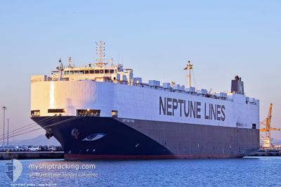
NEPTUNE PHOS
Vehicles Carrier
Current Trip
| Time Travelled | 15 h, 5 mins |
|---|---|
| Remaining Time | 3 days |
| Distance Travelled | 230.23 nm |
| Remaining Distance | 1291.51 nm |
| AVG Speed | 14.7 Knots |
| MAX Speed | 17.3 Knots |
| AVG Wind | 10.4 knots |
| MAX Wind | 21.3 knots |
| MIN Temp | 13.2°C / 55.76°F |
| MAX Temp | 21.7°C / 71.06°F |
| Draught | 8.4 m |
| Position Received | 1 m ago |
Current Position
| Longitude | --- |
|---|---|
| Latitude | --- |
| Status | Under way using engine |
| Speed | 16.3 Knots |
| Course | 207° |
| Area | Aegean Sea |
| Station | T-AIS |
| Position Received | 1 m ago |
Info
Information
The current position of NEPTUNE PHOS is in Aegean Sea with coordinates 39.47212° / 25.58833° as reported on 2025-03-14 04:12 by AIS to our vessel tracker app. The vessel's current speed is 16.3 Knots and is heading at the port of FOS. The estimated time of arrival as calculated by MyShipTracking vessel tracking app is 2025-03-17 13:33 LT
The vessel NEPTUNE PHOS (IMO: 9451719, MMSI: 241909000) is a Vehicles Carrier that was built in 2009 ( 16 years old ). It's sailing under the flag of [GR] Greece.
In this page you can find informations about the vessels current position, last detected port calls, and current voyage information. If the vessels is not in coverage by AIS you will find the latest position.
The current position of NEPTUNE PHOS is detected by our AIS receivers and we are not responsible for the reliability of the data. The last position was recorded while the vessel was in Coverage by the Ais receivers of our vessel tracking app.
The current draught of NEPTUNE PHOS as reported by AIS is 8.4 meters
Weather
| Temperature | 16°C / 60.8°F |
|---|---|
| Wind Speed | 20 knots |
| Direction | 184° S |
| Pressure | 1014 hPa |
| Humidity | 84.7 % |
| Cloud Coverage | 3 % |
Featured Company
Last Port Calls
| Port | Arrival | Departure | Time In Port |
|---|---|---|---|
| 2025-03-12 22:02 | 2025-03-13 13:09 | 15 h | |
| 2025-03-12 11:19 | 2025-03-12 20:44 | 9 h | |
| 2025-03-09 12:16 | 2025-03-10 23:14 | 1 d | |
| 2025-03-07 19:22 | 2025-03-08 08:43 | 13 h | |
| 2025-03-06 05:34 | 2025-03-06 17:39 | 12 h | |
| 2025-03-01 21:18 | 2025-03-02 18:41 | 21 h | |
| 2025-02-28 02:33 | 2025-03-01 08:43 | 1 d | |
| 2025-02-22 13:00 | 2025-02-23 03:03 | 14 h | |
| 2025-02-21 10:03 | 2025-02-21 22:30 | 12 h | |
| 2025-02-18 08:19 | 2025-02-19 19:26 | 1 d |
Last Trips
| Origin | Departure | Destination | Arrival | Distance | |
|---|---|---|---|---|---|
| 2025-03-12 23:44 | 2025-03-13 01:02 | 6.59 nm | |||
| 2025-03-11 01:14 | 2025-03-12 14:19 | 275.63 nm | |||
| 2025-03-08 11:43 | 2025-03-09 14:16 | 234.31 nm | |||
| 2025-03-06 19:39 | 2025-03-07 22:22 | 386.61 nm | |||
| 2025-03-02 19:41 | 2025-03-06 07:34 | 1166.31 nm | |||
| 2025-03-01 09:43 | 2025-03-01 22:18 | 189.28 nm | |||
| 2025-02-23 03:03 | 2025-02-28 03:33 | 1040.65 nm | |||
| 2025-02-21 23:30 | 2025-02-22 14:00 | 183.50 nm | |||
| 2025-02-19 20:26 | 2025-02-21 11:03 | 571.88 nm | |||
| 2025-02-17 12:36 | 2025-02-18 09:19 | 286.83 nm |
Events
| Time | Event | Details | Position / Dest | Info |
|---|---|---|---|---|
| 2025-03-14 02:24 | Change Sea Area | Greek part of the Aegean Sea Turkish part of the Aegean Sea |
39.89657 / 25.87005
Aegean Sea
FRFOS
|
Speed: 15.6 kn Course: 209° |
| 2025-03-14 01:24 | Change Sea Area | Turkish part of the Aegean Sea Turkish part of the Sea of Marmara |
40.02277 / 26.15277
Aegean Sea
FRFOS
|
Speed: 16.6 kn Course: 262° |
| 2025-03-13 23:32 | ETA Changed | 2025/03/17 10:00 2025/03/17 02:00 |
40.29445 / 26.56677
FRFOS
|
Speed: 17 kn Course: 227° |
| 2025-03-13 23:11 | IN Coverage |
40.36513 / 26.65408
Sea of Marmara
FRFOS
|
Speed: 16.6 kn Course: 213° |
|
| 2025-03-13 19:52 | OUT of Coverage |
40.76893 / 27.62407
Sea of Marmara
FRFOS
|
Speed: 16.9 kn Course: 256° |
|
| 2025-03-13 15:56 | Draught Changed | 8.4 0 |
40.74473 / 29.06518
FRFOS
|
Speed: 17 kn Course: 269° |
| 2025-03-13 15:50 | Draught Changed | 0 8.4 |
40.74497 / 29.10142
|
Speed: 17 kn Course: 268° |
| 2025-03-13 13:09 | PORT DEPARTURE |
|
40.73462 / 29.85512
FRFOS
|
Speed: 5.4 kn Course: 6° |
| 2025-03-13 13:07 | START Moving |
40.73232 / 29.85495
[TR] LIMAS
|
Speed: 3.7 kn Course: 0° |
|
| 2025-03-13 13:03 | Status Changed | Under way using engine Moored |
40.73108 / 29.85548
[TR] LIMAS
|
Speed: Course: 0° |