
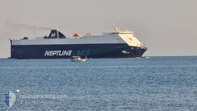
NEPTUNE OKEANIS
Vehicles Carrier
Current Trip
MAPTM
| Time Travelled | 1 day |
|---|---|
| Remaining Time | --- |
| Distance Travelled | 347.79 nm |
| Remaining Distance | --- |
| AVG Speed | 17.4 Knots |
| MAX Speed | 20.5 Knots |
| AVG Wind | 10.3 knots |
| MAX Wind | 17.8 knots |
| MIN Temp | 12.6°C / 54.68°F |
| MAX Temp | 16.7°C / 62.06°F |
| Draught | 5.3 m |
| Position Received | 8 h, 52 m ago |
Current Position
| Longitude | --- |
|---|---|
| Latitude | --- |
| Status | Under way using engine |
| Speed | 17 Knots |
| Course | 34° |
| Area | Mediterranean Sea - Western Basin |
| Station | T-AIS |
| Position Received | 8 h, 52 m ago |
Info
Information
The current position of NEPTUNE OKEANIS is in Mediterranean Sea - Western Basin with coordinates 37.79137° / -0.30832° as reported on 2025-12-11 11:02 by AIS to our vessel tracker app. The vessel's current speed is 17 Knots
The vessel NEPTUNE OKEANIS (IMO: 9306706, MMSI: 215912000) is a Vehicles Carrier that was built in 2005 ( 20 years old ). It's sailing under the flag of [MT] Malta.
In this page you can find informations about the vessels current position, last detected port calls, and current voyage information. If the vessels is not in coverage by AIS you will find the latest position.
The current position of NEPTUNE OKEANIS is detected by our AIS receivers and we are not responsible for the reliability of the data. The last position was recorded while the vessel was in Coverage by the Ais receivers of our vessel tracking app.
The current draught of NEPTUNE OKEANIS as reported by AIS is 5.3 meters
Weather
| Temperature | 15.5°C / 59.9°F |
|---|---|
| Wind Speed | 5 knots |
| Direction | 154° SSE |
| Pressure | 1021.8 hPa |
| Humidity | 79.6 % |
| Cloud Coverage | 1 % |
Featured Company
Last Port Calls
| Port | Arrival | Departure | Time In Port |
|---|---|---|---|
| 2025-12-09 10:46 | 2025-12-10 19:20 | 1 d | |
| 2025-12-07 06:44 | |||
| 2025-12-06 04:05 | 2025-12-06 20:41 | 16 h | |
| 2025-12-03 09:22 | 2025-12-04 07:16 | 21 h | |
| 2025-11-30 04:00 | 2025-11-30 20:36 | 16 h | |
| 2025-11-27 00:41 | 2025-11-28 04:18 | 1 d | |
| 2025-11-26 05:11 | 2025-11-26 17:35 | 12 h | |
| 2025-11-23 15:48 | 2025-11-24 16:01 | 1 d | |
| 2025-11-17 03:59 | 2025-11-17 16:31 | 12 h | |
| 2025-11-16 19:51 | 2025-11-16 22:17 | 2 h |
Last Trips
| Origin | Departure | Destination | Arrival | Distance | |
|---|---|---|---|---|---|
| 2025-12-06 20:41 | 2025-12-07 06:44 | 74.39 nm | |||
| 2025-12-04 07:16 | 2025-12-06 04:05 | 708.47 nm | |||
| 2025-11-30 20:36 | 2025-12-03 09:22 | 734.92 nm | |||
| 2025-11-28 04:18 | 2025-11-30 04:00 | 710.03 nm | |||
| 2025-11-26 17:35 | 2025-11-27 00:41 | 84.34 nm | |||
| 2025-11-24 16:01 | 2025-11-26 05:11 | 472.75 nm | |||
| 2025-11-17 16:31 | 2025-11-23 15:48 | 1584.04 nm | |||
| 2025-11-16 22:17 | 2025-11-17 03:59 | 76.60 nm | |||
| 2025-11-16 05:36 | 2025-11-16 19:51 | 15.25 nm | |||
| 2025-11-16 05:36 | 2025-11-16 19:45 | 15.25 nm |
Events
| Time | Event | Details | Position / Dest | Info |
|---|---|---|---|---|
| 2025-12-11 11:02 | OUT of Coverage |
37.79137 / -.30832
Mediterranean Sea - Western Basin
|
Speed: 17 kn Course: 34° |
|
| 2025-12-11 10:30 | Change Sea Area | Spanish part of the Mediterranean Sea - Western Basin Spanish part of the Alboran Sea |
37.66533 / -.41610
Mediterranean Sea - Western Basin
|
Speed: 17 kn Course: 33° |
| 2025-12-11 10:29 | Status Changed | Under way using engine Default |
37.66138 / -.41942
MAPTM
|
Speed: 17 kn Course: 34° |
| 2025-12-11 10:20 | IN Coverage |
37.66533 / -.41610
Mediterranean Sea - Western Basin
|
Speed: 17 kn Course: 33° |
|
| 2025-12-10 19:49 | Status Changed | Default Under way using engine |
36.02937 / -4.97667
MAPTM
|
Speed: 17.2 kn Course: 80° |
| 2025-12-10 19:43 | Detected in Sea | Spanish part of the Alboran Sea |
36.02513 / -5.01152
Alboran Sea
|
Speed: 17.2 kn Course: 80° |
| 2025-12-10 19:43 | Status Changed | Under way using engine Default |
36.02513 / -5.01152
MAPTM
|
Speed: 17 kn Course: 81° |
| 2025-12-10 19:43 | OUT of Coverage |
36.02513 / -5.01152
Alboran Sea
|
Speed: 17.2 kn Course: 80° |
|
| 2025-12-10 19:00 | Status Changed | Default Under way using engine |
35.99053 / -5.29038
MAPTM
|
Speed: 19.8 kn Course: 72° |
| 2025-12-10 18:48 | Change Sea Area | Spanish part of the Strait of Gibraltar Moroccan part of the Strait of Gibraltar |
35.97243 / -5.36688
Strait of Gibraltar
|
Speed: 19.7 kn Course: 70° |