
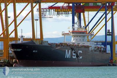
MSC LEA II
Container Ship
Current Trip
| Time Travelled | 6 days |
|---|---|
| Remaining Time | --- |
| Distance Travelled | 1423.70 nm |
| Remaining Distance | --- |
| AVG Speed | 10.7 Knots |
| MAX Speed | 10.7 Knots |
| AVG Wind | 10.4 knots |
| MAX Wind | 26.3 knots |
| MIN Temp | 4.5°C / 40.1°F |
| MAX Temp | 18.1°C / 64.58°F |
| Draught | 8.8 m |
| Position Received | 2 d ago |
Current Position
| Longitude | --- |
|---|---|
| Latitude | --- |
| Status | Under way using engine |
| Speed | 12.2 Knots |
| Course | 73.8° |
| Area | Black Sea |
| Station | T-AIS |
| Position Received | 2 d ago |
Info
Information
The current position of MSC LEA II is in Black Sea with coordinates 41.33428° / 29.56869° as reported on 2025-12-18 16:02 by AIS to our vessel tracker app. The vessel's current speed is 12.2 Knots
The vessel MSC LEA II (IMO: 9162643, MMSI: 636018325) is a Container Ship that was built in 2000 ( 25 years old ). It's sailing under the flag of [LR] Liberia.
In this page you can find informations about the vessels current position, last detected port calls, and current voyage information. If the vessels is not in coverage by AIS you will find the latest position.
The current position of MSC LEA II is detected by our AIS receivers and we are not responsible for the reliability of the data. The last position was recorded while the vessel was in Coverage by the Ais receivers of our vessel tracking app.
The current draught of MSC LEA II as reported by AIS is 8.8 meters
Weather
| Temperature | 8.7°C / 47.66°F |
|---|---|
| Wind Speed | 4 knots |
| Direction | 58° ENE |
| Pressure | 1021 hPa |
| Humidity | 70.7 % |
| Cloud Coverage | --- |
Featured Company
Last Port Calls
| Port | Arrival | Departure | Time In Port |
|---|---|---|---|
| 2025-12-14 06:05 | 2025-12-14 18:40 | 12 h | |
| 2025-12-11 16:00 | 2025-12-12 14:00 | 22 h | |
| 2025-12-04 21:43 | 2025-12-05 01:43 | 3 h | |
| 2025-12-04 03:12 | 2025-12-04 21:38 | 18 h | |
| 2025-11-25 10:52 | 2025-11-26 02:42 | 15 h | |
| 2025-11-23 23:21 | 2025-11-24 07:52 | 8 h | |
| 2025-11-17 00:28 | 2025-11-17 13:56 | 13 h | |
| 2025-11-16 20:40 | 2025-11-16 23:46 | 3 h | |
| 2025-11-16 16:53 | 2025-11-16 20:24 | 3 h | |
| 2025-11-07 21:06 | 2025-11-08 17:37 | 20 h |
Most Visited Ports (Last year)
| Port | Arrivals | |
|---|---|---|
| 16 | ||
| 12 | ||
| 10 | ||
| 6 | ||
| 5 | ||
| 5 |
Last Trips
| Origin | Departure | Destination | Arrival | Distance | |
|---|---|---|---|---|---|
| 2025-12-12 14:00 | 2025-12-14 06:05 | 316.72 nm | |||
| 2025-12-05 01:43 | 2025-12-11 16:00 | 1364.45 nm | |||
| 2025-12-04 21:38 | 2025-12-04 21:43 | 1.06 nm | |||
| 2025-11-26 02:42 | 2025-12-04 03:12 | 1550.06 nm | |||
| 2025-11-24 07:52 | 2025-11-25 10:52 | 345.88 nm | |||
| 2025-11-17 13:56 | 2025-11-23 23:21 | 1481.87 nm | |||
| 2025-11-16 23:46 | 2025-11-17 00:28 | 5.40 nm | |||
| 2025-11-16 20:24 | 2025-11-16 20:40 | 3.29 nm | |||
| 2025-11-08 17:37 | 2025-11-16 16:53 | 1406.94 nm | |||
| 2025-11-03 18:54 | 2025-11-07 21:06 | 254.71 nm |
Events
| Time | Event | Details | Position / Dest | Info |
|---|---|---|---|---|
| 2025-12-20 17:07 | START Moving | 4.29 nm, North West of GELENDZHIK |
44.61008 / 37.96295
RUNVS
|
Speed: 52.7 kn Course: 326° |
| 2025-12-20 15:09 | STOP Moving | 5.21 nm, West of GELENDZHIK |
44.55345 / 37.92632
RUNVS
|
Speed: Course: 52° |
| 2025-12-18 16:10 | Status Changed | Default Under way using engine |
41.34169 / 29.60279
RUNVS
|
Speed: 12.2 kn Course: 73.8° |
| 2025-12-18 16:02 | OUT of Coverage |
41.33428 / 29.56869
Black Sea
RUNVS
|
Speed: 12.2 kn Course: 73.8° |
|
| 2025-12-18 15:41 | Status Changed | Under way using engine Default |
41.31542 / 29.47766
RUNVS
|
Speed: 12.2 kn Course: 74° |
| 2025-12-18 15:38 | Status Changed | Default Under way using engine |
41.31247 / 29.46383
RUNVS
|
Speed: 12.2 kn Course: 74.9° |
| 2025-12-18 15:30 | Status Changed | Under way using engine Default |
41.30566 / 29.43039
RUNVS
|
Speed: 12.2 kn Course: 74° |
| 2025-12-18 15:18 | Status Changed | Default Under way using engine |
41.29458 / 29.37854
RUNVS
|
Speed: 12.1 kn Course: 72.6° |
| 2025-12-18 14:22 | Change Sea Area | Turkish part of the Black Sea Turkish part of the Sea of Marmara |
41.23613 / 29.14403
Black Sea
RUNVS
|
Speed: 11.9 kn Course: 41° |
| 2025-12-18 09:38 | ETA Changed | 2025/12/20 07:00 2025/12/19 12:00 |
40.77819 / 28.94087
RUNVS
|
Speed: 1.7 kn Course: 188° |