
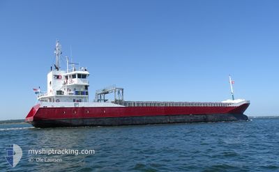
MILA
General Cargo
Current Trip
| Time Travelled | 1 day |
|---|---|
| Remaining Time | --- |
| Distance Travelled | 407.59 nm |
| Remaining Distance | --- |
| AVG Speed | 10.2 Knots |
| MAX Speed | 11.2 Knots |
| AVG Wind | 11.6 knots |
| MAX Wind | 20 knots |
| MIN Temp | 2.8°C / 37.04°F |
| MAX Temp | 8.6°C / 47.48°F |
| Draught | 4.6 m |
| Position Received | 1 m ago |
Current Position
| Longitude | 10.19355° |
|---|---|
| Latitude | 54.38679° |
| Status | Under way using engine |
| Speed | 7.7 Knots |
| Course | 221.4° |
| Area | Baltic Sea |
| Station | T-AIS |
| Position Received | 1 m ago |
Info
Information
The current position of MILA is in Baltic Sea with coordinates 54.38679° / 10.19355° as reported on 2024-04-26 15:19 by AIS to our vessel tracker app. The vessel's current speed is 7.7 Knots and is heading at the port of ELLESMERE. The estimated time of arrival as calculated by MyShipTracking vessel tracking app is 2024-05-01 06:00 LT
The vessel MILA (IMO: 9331335, MMSI: 246542000) is a General Cargo that was built in 2006 ( 18 years old ). It's sailing under the flag of [NL] Netherlands.
In this page you can find informations about the vessels current position, last detected port calls, and current voyage information. If the vessels is not in coverage by AIS you will find the latest position.
The current position of MILA is detected by our AIS receivers and we are not responsible for the reliability of the data. The last position was recorded while the vessel was in Coverage by the Ais receivers of our vessel tracking app.
The current draught of MILA as reported by AIS is 4.6 meters
Weather
| Temperature | 8.6°C / 47.48°F |
|---|---|
| Wind Speed | 10 knots |
| Direction | 220° SW |
| Pressure | 1003.9 hPa |
| Humidity | 74.6 % |
| Cloud Coverage | 92 % |
Featured Company
Last Port Calls
| Port | Arrival | Departure | Time In Port |
|---|---|---|---|
| 2024-04-24 10:36 | 2024-04-25 00:33 | 13 h | |
| 2024-04-21 09:48 | 2024-04-22 16:03 | 1 d | |
| 2024-04-16 05:15 | 2024-04-16 13:59 | 8 h | |
| 2024-04-14 13:52 | 2024-04-15 12:40 | 22 h | |
| 2024-03-23 13:16 | 2024-04-09 18:55 | 17 d | |
| 2024-03-14 14:39 | 2024-03-18 19:04 | 4 d | |
| 2024-03-12 14:03 | 2024-03-12 15:21 | 1 h | |
| 2024-03-08 23:26 | 2024-03-10 15:36 | 1 d | |
| 2024-03-05 18:30 | 2024-03-08 19:48 | 3 d | |
| 2024-02-25 17:24 | 2024-02-27 17:17 | 1 d |
Last Trips
| Origin | Departure | Destination | Arrival | Distance | |
|---|---|---|---|---|---|
| 2024-04-22 18:03 | 2024-04-24 13:36 | 456.28 nm | |||
| 2024-04-16 15:59 | 2024-04-21 11:48 | 983.63 nm | |||
| 2024-04-15 14:40 | 2024-04-16 07:15 | 127.64 nm | |||
| 2024-04-09 21:55 | 2024-04-14 15:52 | 862.36 nm | |||
| 2024-03-18 20:04 | 2024-03-23 15:16 | 1097.55 nm | |||
| 2024-03-12 16:21 | 2024-03-14 15:39 | 401.91 nm | |||
| 2024-03-10 16:36 | 2024-03-12 15:03 | 431.48 nm | |||
| 2024-03-08 20:48 | 2024-03-09 00:26 | 40.13 nm | |||
| 2024-02-27 17:17 | 2024-03-05 19:30 | 1522.93 nm | |||
| 2024-02-24 08:13 | 2024-02-25 17:24 | 322.45 nm |
Events
| Time | Event | Details | Position / Dest | Info |
|---|---|---|---|---|
| 2024-04-26 13:29 | Change Sea Area | German part of the Baltic Sea Danish part of the Baltic Sea |
54.56388 / 10.55453
Baltic Sea
ELLESMERE PORT
|
Speed: 9.9 kn Course: 248° |
| 2024-04-26 12:35 | Detected in Sea | Danish part of the Baltic Sea |
54.58769 / 10.81147
Baltic Sea
ELLESMERE PORT
|
Speed: 10 kn Course: 264.2° |
| 2024-04-26 11:05 | Detected in Sea | German part of the Baltic Sea |
54.59294 / 11.24301
Baltic Sea
ELLESMERE PORT
|
Speed: 10.7 kn Course: 296.1° |
| 2024-04-26 04:16 | Change Sea Area | Danish part of the Baltic Sea German part of the Baltic Sea |
54.84230 / 12.94103
Baltic Sea
ELLESMERE PORT
|
Speed: 10.2 kn Course: 245.5° |
| 2024-04-26 01:10 | Detected in Sea | German part of the Baltic Sea |
55.01206 / 13.81142
Baltic Sea
ELLESMERE PORT
|
Speed: 10.4 kn Course: 250.7° |
| 2024-04-25 21:25 | Change Sea Area | Swedish part of the Baltic Sea Danish part of the Kattegat |
55.44213 / 14.65309
Baltic Sea
ELLESMERE PORT
|
Speed: 10.5 kn Course: 248° |
| 2024-04-25 18:56 | Change Sea Area | Danish part of the Kattegat Swedish part of the Baltic Sea |
55.61731 / 15.35781
Kattegat
ELLESMERE PORT
|
Speed: 10.6 kn Course: 250.7° |
| 2024-04-25 15:22 | Status Changed | Under way using engine Default |
55.79687 / 16.42177
ELLESMERE PORT
|
Speed: 11 kn Course: 255° |
| 2024-04-25 15:12 | Status Changed | Default Under way using engine |
55.80484 / 16.47423
ELLESMERE PORT
|
Speed: 11 kn Course: 255.8° |
| 2024-04-25 14:33 | Draught Changed | 4.6 3.6 |
55.83595 / 16.68045
ELLESMERE PORT
|
Speed: 10.9 kn Course: 254.7° |