
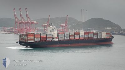
MERKUR ARCHIPELAGO
Container Ship
Current Trip
| Time Travelled | 7 days |
|---|---|
| Remaining Time | 2 days |
| Distance Travelled | 2067.36 nm |
| Remaining Distance | 690.65 nm |
| AVG Speed | 13.8 Knots |
| MAX Speed | 20.3 Knots |
| AVG Wind | 15.3 knots |
| MAX Wind | 29 knots |
| MIN Temp | 19.3°C / 66.74°F |
| MAX Temp | 27.8°C / 82.04°F |
| Draught | 12.6 m |
| Position Received | 7 d ago |
Current Position
| Longitude | --- |
|---|---|
| Latitude | --- |
| Status | Under way using engine |
| Speed | 18.1 Knots |
| Course | 49.7° |
| Area | Singapore Strait |
| Station | T-AIS |
| Position Received | 7 d ago |
Info
Information
The current position of MERKUR ARCHIPELAGO is in Singapore Strait with coordinates 1.30295° / 104.34538° as reported on 2025-12-27 05:47 by AIS to our vessel tracker app. The vessel's current speed is 18.1 Knots and is heading at the port of HAI PHONG. The estimated time of arrival as calculated by MyShipTracking vessel tracking app is 2026-01-06 18:47 LT
The vessel MERKUR ARCHIPELAGO (IMO: 9456977, MMSI: 636091883) is a Container Ship that was built in 2009 ( 17 years old ). It's sailing under the flag of [LR] Liberia.
In this page you can find informations about the vessels current position, last detected port calls, and current voyage information. If the vessels is not in coverage by AIS you will find the latest position.
The current position of MERKUR ARCHIPELAGO is detected by our AIS receivers and we are not responsible for the reliability of the data. The last position was recorded while the vessel was in Coverage by the Ais receivers of our vessel tracking app.
The current draught of MERKUR ARCHIPELAGO as reported by AIS is 12.6 meters
Weather
| Temperature | 23.5°C / 74.3°F |
|---|---|
| Wind Speed | 3 knots |
| Direction | 2° N |
| Pressure | 1014.9 hPa |
| Humidity | 73.2 % |
| Cloud Coverage | 83 % |
Featured Company
Last Port Calls
| Port | Arrival | Departure | Time In Port |
|---|---|---|---|
| 2025-12-26 15:11 | 2025-12-27 10:59 | 19 h | |
| 2025-12-24 10:46 | 2025-12-25 21:58 | 1 d | |
| 2025-12-11 21:53 | 2025-12-12 14:02 | 16 h | |
| 2025-12-10 06:33 | 2025-12-11 07:51 | 1 d | |
| 2025-11-28 07:21 | 2025-11-29 07:58 | 1 d | |
| 2025-11-26 11:33 | 2025-11-27 15:08 | 1 d | |
| 2025-11-13 15:34 | 2025-11-14 08:29 | 16 h | |
| 2025-11-12 08:08 | 2025-11-13 03:56 | 19 h |
Most Visited Ports (Last year)
| Port | Arrivals | |
|---|---|---|
| 24 | ||
| 23 | ||
| 1 |
Last Trips
| Origin | Departure | Destination | Arrival | Distance | |
|---|---|---|---|---|---|
| 2025-12-25 21:58 | 2025-12-26 15:11 | 156.90 nm | |||
| 2025-12-12 14:02 | 2025-12-24 10:46 | 2884.79 nm | |||
| 2025-12-11 07:51 | 2025-12-11 21:53 | 128.20 nm | |||
| 2025-11-29 07:58 | 2025-12-10 06:33 | 2791.92 nm | |||
| 2025-11-27 15:08 | 2025-11-28 07:21 | 167.64 nm | |||
| 2025-11-14 08:29 | 2025-11-26 11:33 | 2805.79 nm | |||
| 2025-11-13 03:56 | 2025-11-13 15:34 | 83.80 nm | |||
| 2025-10-31 02:36 | 2025-11-12 08:08 | 2788.63 nm |
Events
| Time | Event | Details | Position / Dest | Info |
|---|---|---|---|---|
| 2026-01-01 03:45 | START Moving |
17.70833 / 108.65500
HAI PHONG
|
Speed: 4 kn Course: -1° |
|
| 2026-01-01 03:36 | STOP Moving |
17.71333 / 108.65667
HAI PHONG
|
Speed: Course: -1° |
|
| 2025-12-31 08:28 | START Moving | 10.63 nm, East of HAI PHONG |
20.79475 / 106.91370
HAI PHONG
|
Speed: 5.3 kn Course: 151° |
| 2025-12-30 05:27 | STOP Moving | 10.88 nm, South East of HAI PHONG |
20.78794 / 106.91569
HAI PHONG
|
Speed: 0.1 kn Course: 329° |
| 2025-12-27 05:52 | Status Changed | Default Under way using engine |
1.32265 / 104.36788
HAI PHONG
|
Speed: 18.1 kn Course: 49.7° |
| 2025-12-27 05:47 | OUT of Coverage |
1.30295 / 104.34538
Singapore Strait
HAI PHONG
|
Speed: 18.1 kn Course: 49.7° |
|
| 2025-12-27 05:43 | Status Changed | Under way using engine Default |
1.29300 / 104.33127
HAI PHONG
|
Speed: 18.5 kn Course: 74° |
| 2025-12-27 05:40 | Status Changed | Default Under way using engine |
1.28925 / 104.31838
HAI PHONG
|
Speed: 18.5 kn Course: 78.5° |
| 2025-12-27 05:10 | Change Sea Area | Malaysian part of the Singapore Strait Indonesian part of the Singapore Strait |
1.26188 / 104.16496
Singapore Strait
HAI PHONG
|
Speed: 17.4 kn Course: 81.8° |
| 2025-12-27 04:04 | Change Sea Area | Indonesian part of the Singapore Strait Singaporean part of the Singapore Strait |
1.20386 / 103.88196
Singapore Strait
HAI PHONG
|
Speed: 14.3 kn Course: 62.9° |