
MEGAN
Yacht
Current Trip
| Trip Time | 3 days |
|---|---|
| Trip Distance | 1128.27 nm |
| AVG Speed | 11.8 Knots |
| MAX Speed | 15.2 Knots |
| Draught | 2.7 m |
| AVG Wind | 11.9 knots |
| MAX Wind | 22 knots |
| MIN Temp | 8.3°C / 46.94°F |
| MAX Temp | 15.9°C / 60.62°F |
| Position Received | 6 m ago |
Current Position
| Longitude | --- |
|---|---|
| Latitude | --- |
| Status | Moored |
| Speed | 0.2 Knots |
| Course | 280° |
| Area | Mediterranean Sea - Eastern Basin |
| Station | T-AIS |
| Position Received | 6 m ago |
Info
Information
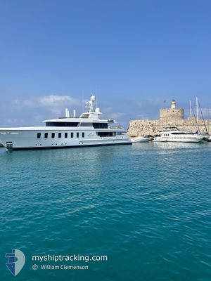
The current position of MEGAN is in Mediterranean Sea - Eastern Basin with coordinates 36.45097° / 28.22680° as reported on 2025-03-05 06:57 by AIS to our vessel tracker app. The vessel's current speed is 0.2 Knots and is currently inside the port of RHODES.
The vessel MEGAN (IMO: 1010571, MMSI: 319039900) is a Yacht that was built in 2011 ( 14 years old ). It's sailing under the flag of [KY] Cayman Is.
In this page you can find informations about the vessels current position, last detected port calls, and current voyage information. If the vessels is not in coverage by AIS you will find the latest position.
The current position of MEGAN is detected by our AIS receivers and we are not responsible for the reliability of the data. The last position was recorded while the vessel was in Coverage by the Ais receivers of our vessel tracking app.
The current draught of MEGAN as reported by AIS is 2.7 meters
Weather
| Temperature | 14.7°C / 58.46°F |
|---|---|
| Wind Speed | 5 knots |
| Direction | 338° NNW |
| Pressure | 1018.7 hPa |
| Humidity | 52.8 % |
| Cloud Coverage | 3 % |
Featured Company
Events
| Time | Event | Details | Position / Dest | Info |
|---|---|---|---|---|
| 2025-03-02 04:48 | Status Changed | Moored Under way using engine |
36.45097 / 28.22680
[GR] RHODES
|
Speed: 0.2 kn Course: 279° |
| 2025-03-01 17:21 | STOP Moving |
36.45081 / 28.22642
[GR] RHODES
|
Speed: 0.1 kn Course: 230° |
|
| 2025-03-01 17:15 | PORT ARRIVAL |
|
36.45255 / 28.22828
[GR] RHODES
|
Speed: 4 kn Course: 229° |
| 2025-03-01 17:08 | Change Sea Area | Greek part of the Mediterranean Sea - Eastern Basin Greek part of the Aegean Sea |
36.46432 / 28.22427
Mediterranean Sea - Eastern Basin
|
Speed: 10.6 kn Course: 114° |
| 2025-03-01 17:01 | IN Coverage |
36.46372 / 28.19107
Aegean Sea
|
Speed: 15 kn Course: 79.5° |
|
| 2025-03-01 12:40 | OUT of Coverage |
36.26789 / 26.96305
Aegean Sea
|
Speed: 14 kn Course: 83.6° |
|
| 2025-03-01 12:40 | IN Coverage |
36.26789 / 26.96305
Aegean Sea
|
Speed: 14 kn Course: 83.6° |
|
| 2025-03-01 11:24 | OUT of Coverage |
36.23606 / 26.60730
Aegean Sea
|
Speed: 14.5 kn Course: 86° |
|
| 2025-03-01 06:04 | Status Changed | Under way using engine At anchor |
36.30119 / 25.08332
RHODOS
|
Speed: 13.9 kn Course: 89.9° |
| 2025-03-01 06:03 | Status Changed | At anchor Under way using engine |
36.30122 / 25.08188
RHODOS
|
Speed: 13.6 kn Course: 91.1° |