
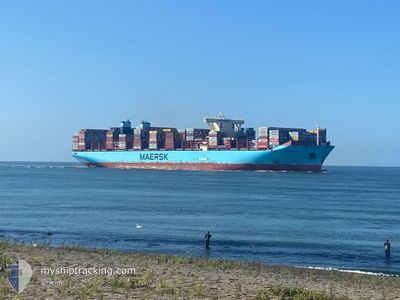
MATHILDE MAERSK
Cargo A
Current Trip
| Time Travelled | 57 days |
|---|---|
| Remaining Time | --- |
| Distance Travelled | 329.50 nm |
| Remaining Distance | 158.20 nm |
| AVG Speed | 7.2 Knots |
| MAX Speed | 14.4 Knots |
| AVG Wind | 10.1 knots |
| MAX Wind | 24 knots |
| MIN Temp | 5.3°C / 41.54°F |
| MAX Temp | 13°C / 55.4°F |
| Draught | 14.3 m |
| Position Received | 2024-12-28 20:52 |
Current Position
| Longitude | --- |
|---|---|
| Latitude | --- |
| Status | Under way using engine |
| Speed | 13.1 Knots |
| Course | 47.3° |
| Area | South China Sea |
| Station | T-AIS |
| Position Received | 2024-12-28 20:52 |
Info
Information
The current position of MATHILDE MAERSK is in South China Sea with coordinates 1.33372° / 104.39468° as reported on 2024-12-28 20:52 by AIS to our vessel tracker app. The vessel's current speed is 13.1 Knots and is heading at the port of SHANGHAI.
The vessel MATHILDE MAERSK (IMO: 9632179, MMSI: 219646000) is a Cargo A It's sailing under the flag of [DK] Denmark.
In this page you can find informations about the vessels current position, last detected port calls, and current voyage information. If the vessels is not in coverage by AIS you will find the latest position.
The current position of MATHILDE MAERSK is detected by our AIS receivers and we are not responsible for the reliability of the data. The last position was recorded while the vessel was in Coverage by the Ais receivers of our vessel tracking app.
The current draught of MATHILDE MAERSK as reported by AIS is 14.3 meters
Weather
| Temperature | 11.2°C / 52.16°F |
|---|---|
| Wind Speed | 8 knots |
| Direction | 34° NE |
| Pressure | 1020.8 hPa |
| Humidity | 86 % |
| Cloud Coverage | 100 % |
Featured Company
Most Visited Ports (Last year)
| Port | Arrivals | |
|---|---|---|
| 5 | ||
| 5 | ||
| 4 | ||
| 3 | ||
| 3 | ||
| 3 |
Events
| Time | Event | Details | Position / Dest | Info |
|---|---|---|---|---|
| 2025-03-13 06:33 | STOP Moving | 13.3 nm, South East of NINGBO |
29.78352 / 122.02260
MY TPP > CN SGH
|
Speed: 0.3 kn Course: 44° |
| 2025-03-12 13:01 | START Moving |
30.45507 / 122.70887
MY TPP > CN SGH
|
Speed: 6 kn Course: 88° |
|
| 2025-03-12 07:58 | STOP Moving |
30.45375 / 122.70265
MY TPP > CN SGH
|
Speed: 0.3 kn Course: 310° |
|
| 2025-03-12 04:22 | START Moving | 3.26 nm, West of YANGSHAN |
30.60917 / 122.07150
MY TPP > CN SGH
|
Speed: 3.8 kn Course: 139° |
| 2025-03-11 08:06 | STOP Moving | 3.37 nm, West of YANGSHAN |
30.61583 / 122.07010
MY TPP > CN SGH
|
Speed: Course: 307° |
| 2025-03-11 04:43 | START Moving | 15.04 nm, South of SHENGSI |
30.49387 / 122.47832
MY TPP > CN SGH
|
Speed: 4 kn Course: 317° |
| 2025-03-10 17:32 | STOP Moving | 15.21 nm, South of SHENGSI |
30.49138 / 122.48141
MY TPP > CN SGH
|
Speed: 0.1 kn Course: 308° |
| 2025-03-10 13:38 | START Moving | 15.29 nm, South of SHENGSI |
30.49970 / 122.52174
MY TPP > CN SGH
|
Speed: 3.5 kn Course: 331° |
| 2025-03-09 20:08 | STOP Moving | 15.92 nm, South of SHENGSI |
30.48820 / 122.52047
MY TPP > CN SGH
|
Speed: 0.1 kn Course: 74° |
| 2025-03-09 01:06 | START Moving | 8.58 nm, South West of ZHOUSHAN |
29.83510 / 122.13538
MY TPP > CN SGH
|
Speed: 4.9 kn Course: 62° |