
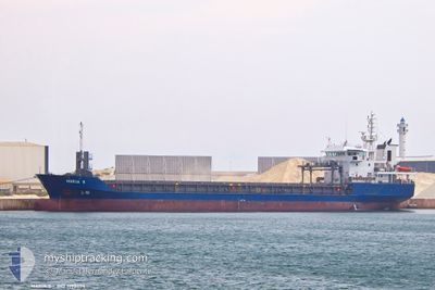
MARIA S
General Cargo
Current Trip
| Trip Time | 14 days |
|---|---|
| Trip Distance | 925.03 nm |
| AVG Speed | 9 Knots |
| MAX Speed | 10.4 Knots |
| Draught | 5.2 m |
| AVG Wind | 6.2 knots |
| MAX Wind | 17 knots |
| MIN Temp | 11.7°C / 53.06°F |
| MAX Temp | 25.4°C / 77.72°F |
| Position Received | 12 m ago |
Current Position
| Longitude | --- |
|---|---|
| Latitude | --- |
| Status | Moored |
| Speed | |
| Course | 340° |
| Area | Aegean Sea |
| Station | T-AIS |
| Position Received | 12 m ago |
Info
Information
The current position of MARIA S is in Aegean Sea with coordinates 40.63683° / 22.91814° as reported on 2025-12-08 10:32 by AIS to our vessel tracker app. The vessel's current speed is 0 Knots and is currently inside the port of THESSALONIKI.
The vessel MARIA S (IMO: 9198654, MMSI: 311001740) is a General Cargo that was built in 2002 ( 23 years old ). It's sailing under the flag of [BS] Bahamas.
In this page you can find informations about the vessels current position, last detected port calls, and current voyage information. If the vessels is not in coverage by AIS you will find the latest position.
The current position of MARIA S is detected by our AIS receivers and we are not responsible for the reliability of the data. The last position was recorded while the vessel was in Coverage by the Ais receivers of our vessel tracking app.
The current draught of MARIA S as reported by AIS is 5.2 meters
Weather
| Temperature | 12.5°C / 54.5°F |
|---|---|
| Wind Speed | 4 knots |
| Direction | 326° NW |
| Pressure | 1020 hPa |
| Humidity | 65.1 % |
| Cloud Coverage | 87 % |
Featured Company
Last Port Calls
| Port | Arrival | Departure | Time In Port |
|---|---|---|---|
| 2025-12-03 20:23 | |||
| 2025-11-19 14:27 | |||
| 2025-11-03 10:20 | 2025-11-05 11:54 | 2 d | |
| 2025-10-25 22:12 | 2025-10-29 03:19 | 3 d | |
| 2025-10-08 09:52 | 2025-10-15 04:52 | 6 d |
Last Trips
| Origin | Departure | Destination | Arrival | Distance | |
|---|---|---|---|---|---|
| 2025-11-19 16:27 | 2025-12-03 22:23 | 925.03 nm | |||
| 2025-10-29 05:19 | 2025-11-03 13:20 | 202.25 nm | |||
| 2025-10-15 07:52 | 2025-10-26 01:12 | 502.85 nm | |||
| 2025-09-19 00:47 | 2025-10-08 12:52 | 1635.57 nm |
Events
| Time | Event | Details | Position / Dest | Info |
|---|---|---|---|---|
| 2025-12-05 06:28 | Status Changed | Moored Under way using engine |
40.63688 / 22.91816
[GR] THESSALONIKI
|
Speed: Course: 340° |
| 2025-12-05 04:52 | Status Changed | Under way using engine At anchor |
40.62322 / 22.93061
[GR] THESSALONIKI
|
Speed: 0.5 kn Course: 229° |
| 2025-12-03 21:22 | ETA Changed | 2026/03/12 21:00 2026/03/12 23:00 |
40.62331 / 22.93020
[GR] THESSALONIKI
|
Speed: 0.4 kn Course: 180° |
| 2025-12-03 21:19 | STOP Moving |
40.62351 / 22.92983
[GR] THESSALONIKI
|
Speed: 0.3 kn Course: 162° |
|
| 2025-12-03 21:08 | Status Changed | At anchor Under way using engine |
40.62201 / 22.92981
[GR] THESSALONIKI
|
Speed: 1 kn Course: 88° |
| 2025-12-03 20:23 | PORT ARRIVAL |
|
40.56769 / 22.89112
[GR] THESSALONIKI
|
Speed: 9.2 kn Course: 50.1° |
| 2025-12-03 16:13 | IN Coverage |
40.01714 / 23.04952
Aegean Sea
|
Speed: 9.8 kn Course: 329.5° |
|
| 2025-12-03 02:24 | OUT of Coverage |
38.29939 / 24.62892
Aegean Sea
|
Speed: 9.3 kn Course: 318.2° |
|
| 2025-12-03 00:49 | IN Coverage |
38.13267 / 24.84733
Aegean Sea
|
Speed: 9.3 kn Course: 316.2° |
|
| 2025-12-02 22:46 | OUT of Coverage |
37.89964 / 25.10615
Aegean Sea
|
Speed: 9.1 kn Course: 318.5° |