
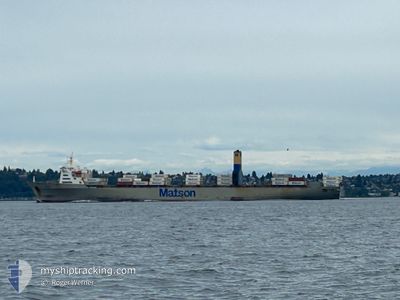
MAHIMAHI
Container Ship
Current Trip
| Time Travelled | 1 day |
|---|---|
| Remaining Time | 3 days |
| Distance Travelled | 529.75 nm |
| Remaining Distance | 2035.10 nm |
| AVG Speed | 17.3 Knots |
| MAX Speed | 21.3 Knots |
| AVG Wind | 10.1 knots |
| MAX Wind | 19 knots |
| MIN Temp | 15.3°C / 59.54°F |
| MAX Temp | 17.4°C / 63.32°F |
| Draught | 9.2 m |
| Position Received | 23 h, 54 m ago |
Current Position
| Longitude | --- |
|---|---|
| Latitude | --- |
| Status | Under way using engine |
| Speed | 17.6 Knots |
| Course | 234.1° |
| Area | North Pacific Ocean |
| Station | T-AIS |
| Position Received | 23 h, 54 m ago |
Info
Information
The current position of MAHIMAHI is in North Pacific Ocean with coordinates 33.01539° / -118.91202° as reported on 2026-01-03 18:16 by AIS to our vessel tracker app. The vessel's current speed is 17.6 Knots and is heading at the port of HONOLULU . The estimated time of arrival as calculated by MyShipTracking vessel tracking app is 2026-01-08 00:12 LT
The vessel MAHIMAHI (IMO: 7907996, MMSI: 366563000) is a Container Ship that was built in 1983 ( 43 years old ). It's sailing under the flag of [US] USA.
In this page you can find informations about the vessels current position, last detected port calls, and current voyage information. If the vessels is not in coverage by AIS you will find the latest position.
The current position of MAHIMAHI is detected by our AIS receivers and we are not responsible for the reliability of the data. The last position was recorded while the vessel was in Coverage by the Ais receivers of our vessel tracking app.
The current draught of MAHIMAHI as reported by AIS is 9.2 meters
Weather
| Temperature | 16.1°C / 60.98°F |
|---|---|
| Wind Speed | 16 knots |
| Direction | 309° NW |
| Pressure | 1017.7 hPa |
| Humidity | 73.3 % |
| Cloud Coverage | 100 % |
Featured Company
Last Port Calls
| Port | Arrival | Departure | Time In Port |
|---|---|---|---|
| 2026-01-01 14:47 | 2026-01-03 04:56 | 1 d | |
| 2025-12-25 07:07 | 2025-12-27 17:35 | 2 d | |
| 2025-12-19 11:56 | 2025-12-20 08:31 | 20 h | |
| 2025-12-17 01:25 | 2025-12-17 18:42 | 17 h | |
| 2025-12-10 16:33 | 2025-12-12 15:09 | 1 d | |
| 2025-12-05 01:09 | 2025-12-06 04:34 | 1 d | |
| 2025-12-03 05:15 | 2025-12-03 18:42 | 13 h | |
| 2025-11-26 16:26 | 2025-11-28 22:24 | 2 d | |
| 2025-11-21 08:45 | 2025-11-22 04:07 | 19 h | |
| 2025-11-19 01:20 | 2025-11-20 08:43 | 1 d |
Most Visited Ports (Last year)
| Port | Arrivals | |
|---|---|---|
| 26 | ||
| 26 | ||
| 25 |
Last Trips
| Origin | Departure | Destination | Arrival | Distance | |
|---|---|---|---|---|---|
| 2025-12-27 17:35 | 2026-01-01 14:47 | 2281.73 nm | |||
| 2025-12-20 08:31 | 2025-12-25 07:07 | 2332.44 nm | |||
| 2025-12-17 18:42 | 2025-12-19 11:56 | 544.80 nm | |||
| 2025-12-12 15:09 | 2025-12-17 01:25 | 2103.15 nm | |||
| 2025-12-06 04:34 | 2025-12-10 16:33 | 2265.44 nm | |||
| 2025-12-03 18:42 | 2025-12-05 01:09 | 519.62 nm | |||
| 2025-11-28 22:24 | 2025-12-03 05:15 | 2103.91 nm | |||
| 2025-11-22 04:07 | 2025-11-26 16:26 | 2266.86 nm | |||
| 2025-11-20 08:43 | 2025-11-21 08:45 | 399.69 nm | |||
| 2025-11-14 15:44 | 2025-11-19 01:20 | 2103.47 nm |
Events
| Time | Event | Details | Position / Dest | Info |
|---|---|---|---|---|
| 2026-01-03 18:23 | Status Changed | Default Under way using engine |
32.99566 / -118.94620
USHNL
|
Speed: 17.6 kn Course: 234.1° |
| 2026-01-03 18:16 | OUT of Coverage |
33.01539 / -118.91202
North Pacific Ocean
USHNL
|
Speed: 17.6 kn Course: 234.1° |
|
| 2026-01-03 18:03 | Status Changed | Under way using engine Default |
33.05111 / -118.85022
USHNL
|
Speed: 17.9 kn Course: 249° |
| 2026-01-03 17:55 | Status Changed | Default Under way using engine |
33.06618 / -118.80563
USHNL
|
Speed: 18 kn Course: 249.1° |
| 2026-01-03 12:56 | PORT DEPARTURE |
|
33.71963 / -118.18333
USHNL
|
Speed: 8.1 kn Course: 169° |
| 2026-01-03 12:20 | START Moving |
33.76387 / -118.22068
[US] LOS ANGELES
|
Speed: 3.1 kn Course: 155° |
|
| 2026-01-03 10:32 | Status Changed | Under way using engine Moored |
33.76903 / -118.21900
[US] LOS ANGELES
|
Speed: Course: 244° |
| 2026-01-03 10:32 | Status Changed | Moored Under way using engine |
33.76902 / -118.21900
[US] LOS ANGELES
|
Speed: Course: 244° |
| 2026-01-03 10:27 | Destination Changed | USHNL USLGB |
33.76902 / -118.21902
[US] LOS ANGELES
|
Speed: Course: 244° |
| 2026-01-03 10:27 | ETA Changed | 2026/01/07 02:30 2026/01/01 18:30 |
33.76902 / -118.21902
[US] LOS ANGELES
|
Speed: Course: 244° |