
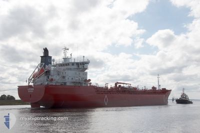
LATANA
Oil/Chemical Tanker
Current Trip
| Time Travelled | 9 h, 15 mins |
|---|---|
| Remaining Time | 9 h, 46 mins |
| Distance Travelled | 119.60 nm |
| Remaining Distance | 123.76 nm |
| AVG Speed | 13.6 Knots |
| MAX Speed | 16.2 Knots |
| AVG Wind | 10.2 knots |
| MAX Wind | 16 knots |
| MIN Temp | 6.1°C / 42.98°F |
| MAX Temp | 10.4°C / 50.72°F |
| Draught | 7.1 m |
| Position Received | 1 m ago |
Current Position
| Longitude | --- |
|---|---|
| Latitude | --- |
| Status | Under way using engine |
| Speed | 13.4 Knots |
| Course | 206.4° |
| Area | North Sea |
| Station | T-AIS |
| Position Received | 1 m ago |
Info
Information
The current position of LATANA is in North Sea with coordinates 53.25016° / 4.47683° as reported on 2025-12-13 02:10 by AIS to our vessel tracker app. The vessel's current speed is 13.4 Knots and is heading at the port of MOERDIJK. The estimated time of arrival as calculated by MyShipTracking vessel tracking app is 2025-12-13 12:57 LT
The vessel LATANA (IMO: 9186352, MMSI: 257374000) is a Oil/Chemical Tanker that was built in 2000 ( 25 years old ). It's sailing under the flag of [NO] Norway.
In this page you can find informations about the vessels current position, last detected port calls, and current voyage information. If the vessels is not in coverage by AIS you will find the latest position.
The current position of LATANA is detected by our AIS receivers and we are not responsible for the reliability of the data. The last position was recorded while the vessel was in Coverage by the Ais receivers of our vessel tracking app.
The current draught of LATANA as reported by AIS is 7.1 meters
Weather
| Temperature | 10°C / 50°F |
|---|---|
| Wind Speed | 15 knots |
| Direction | 293° WNW |
| Pressure | 1021.6 hPa |
| Humidity | 93 % |
| Cloud Coverage | 100 % |
Featured Company
Last Port Calls
| Port | Arrival | Departure | Time In Port |
|---|---|---|---|
| 2025-12-11 16:45 | 2025-12-12 17:56 | 1 d | |
| 2025-12-05 08:59 | 2025-12-09 02:03 | 3 d | |
| 2025-11-22 07:42 | 2025-11-26 02:17 | 3 d | |
| 2025-11-18 22:11 | 2025-11-19 10:04 | 11 h | |
| 2025-11-16 22:06 | 2025-11-18 00:50 | 1 d | |
| 2025-11-12 13:48 | 2025-11-14 12:45 | 1 d | |
| 2025-11-11 22:18 | 2025-11-12 00:21 | 2 h | |
| 2025-11-11 09:01 | 2025-11-11 21:42 | 12 h | |
| 2025-11-08 09:25 | 2025-11-08 17:04 | 7 h | |
| 2025-11-06 11:59 | 2025-11-07 13:53 | 1 d |
Most Visited Ports (Last year)
| Port | Arrivals | |
|---|---|---|
| 40 | ||
| 14 | ||
| 9 | ||
| 8 | ||
| 7 | ||
| 1 |
Last Trips
| Origin | Departure | Destination | Arrival | Distance | |
|---|---|---|---|---|---|
| 2025-12-09 02:03 | 2025-12-11 16:45 | 664.96 nm | |||
| 2025-11-26 02:17 | 2025-12-05 08:59 | 2527.97 nm | |||
| 2025-11-19 10:04 | 2025-11-22 07:42 | 777.01 nm | |||
| 2025-11-18 00:50 | 2025-11-18 22:11 | 245.34 nm | |||
| 2025-11-14 12:45 | 2025-11-16 22:06 | 663.45 nm | |||
| 2025-11-12 00:21 | 2025-11-12 13:48 | 0.93 nm | |||
| 2025-11-11 21:42 | 2025-11-11 22:18 | 0.52 nm | |||
| 2025-11-08 17:04 | 2025-11-11 09:01 | 775.28 nm | |||
| 2025-11-07 13:53 | 2025-11-08 09:25 | 245.79 nm | |||
| 2025-11-03 19:03 | 2025-11-06 11:59 | 665.78 nm |
Events
| Time | Event | Details | Position / Dest | Info |
|---|---|---|---|---|
| 2025-12-12 19:59 | ETA Changed | 2025/12/13 08:00 2025/12/13 15:00 |
53.66791 / 6.21185
DEEME>NLMOE
|
Speed: 14 kn Course: 298° |
| 2025-12-12 19:06 | Change Sea Area | Dutch part of the North Sea German part of the North Sea |
53.61384 / 6.52622
North Sea
DEEME>NLMOE
|
Speed: 15.1 kn Course: 270.9° |
| 2025-12-12 18:58 | Change Sea Area | German part of the North Sea Dutch part of the North Sea |
53.60303 / 6.57950
North Sea
DEEME>NLMOE
|
Speed: 15.8 kn Course: 305.2° |
| 2025-12-12 18:55 | Change Sea Area | Dutch part of the North Sea German part of the North Sea |
53.59267 / 6.60271
North Sea
DEEME>NLMOE
|
Speed: 15.7 kn Course: 307.9° |
| 2025-12-12 18:25 | Change Sea Area | German part of the North Sea Dutch part of the North Sea |
53.51454 / 6.77841
North Sea
DEEME>NLMOE
|
Speed: 15.7 kn Course: 306° |
| 2025-12-12 17:28 | Change Sea Area | Dutch part of the North Sea German part of the North Sea |
53.32560 / 7.00830
North Sea
DEEME>NLMOE
|
Speed: 14 kn Course: 285.9° |
| 2025-12-12 16:56 | PORT DEPARTURE |
|
53.33369 / 7.17597
DEEME>NLMOE
|
Speed: 5.4 kn Course: 253° |
| 2025-12-12 16:51 | START Moving |
53.33592 / 7.18442
[DE] EMDEN
|
Speed: 3.1 kn Course: 244° |
|
| 2025-12-12 15:15 | Status Changed | Under way using engine Moored |
53.34823 / 7.20816
[DE] EMDEN
|
Speed: Course: 296° |
| 2025-12-12 15:02 | Status Changed | Moored Default |
53.34821 / 7.20817
[DE] EMDEN
|
Speed: Course: 296° |