
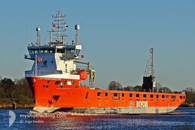
LADY MARIE CHRISTINE
Cargo
Current Trip
SEROR
| Time Travelled | 9 h, 20 mins |
|---|---|
| Remaining Time | --- |
| Distance Travelled | 1.91 nm |
| Remaining Distance | --- |
| AVG Speed | 5.3 Knots |
| MAX Speed | 5.3 Knots |
| AVG Wind | 4.5 knots |
| MAX Wind | 4.6 knots |
| MIN Temp | 4.5°C / 40.1°F |
| MAX Temp | 4.5°C / 40.1°F |
| Draught | 6.5 m |
| Position Received | 2 d ago |
Current Position
| Longitude | 20.90696° |
|---|---|
| Latitude | 63.55795° |
| Status | Under way using engine |
| Speed | 11 Knots |
| Course | 71.7° |
| Area | Gulf of Bothnia |
| Station | T-AIS |
| Position Received | 2 d ago |
Info
Information
The current position of LADY MARIE CHRISTINE is in Gulf of Bothnia with coordinates 63.55795° / 20.90696° as reported on 2024-05-19 13:50 by AIS to our vessel tracker app. The vessel's current speed is 11 Knots
The vessel LADY MARIE CHRISTINE (IMO: 9904326, MMSI: 244017000) is a Cargo It's sailing under the flag of [NL] Netherlands.
In this page you can find informations about the vessels current position, last detected port calls, and current voyage information. If the vessels is not in coverage by AIS you will find the latest position.
The current position of LADY MARIE CHRISTINE is detected by our AIS receivers and we are not responsible for the reliability of the data. The last position was recorded while the vessel was in Coverage by the Ais receivers of our vessel tracking app.
The current draught of LADY MARIE CHRISTINE as reported by AIS is 6.5 meters
Weather
| Temperature | 3.5°C / 38.3°F |
|---|---|
| Wind Speed | 6 knots |
| Direction | 156° SSE |
| Pressure | 1025.6 hPa |
| Humidity | 77.1 % |
| Cloud Coverage | 100 % |
Featured Company
Last Port Calls
| Port | Arrival | Departure | Time In Port |
|---|---|---|---|
| 2024-05-19 21:32 | 2024-05-21 17:28 | 1 d | |
| 2024-05-10 17:21 | 2024-05-11 18:25 | 1 d | |
| 2024-05-04 15:31 | 2024-05-07 10:15 | 2 d | |
| 2024-04-20 17:16 | |||
| 2024-04-16 05:59 | 2024-04-16 06:03 | 3 m | |
| 2024-04-10 04:31 | 2024-04-10 05:14 | 42 m | |
| 2024-04-08 10:28 | 2024-04-08 22:36 | 12 h | |
| 2024-04-02 07:00 | 2024-04-03 10:59 | 1 d | |
| 2024-03-20 01:20 | 2024-03-26 11:29 | 6 d | |
| 2024-03-13 19:23 | 2024-03-15 17:08 | 1 d |
Most Visited Ports (Last year)
| Port | Arrivals | |
|---|---|---|
| 8 | ||
| 5 | ||
| 5 | ||
| 4 | ||
| 3 | ||
| 3 |
Last Trips
| Origin | Departure | Destination | Arrival | Distance | |
|---|---|---|---|---|---|
| 2024-05-11 19:25 | 2024-05-19 23:32 | 2277.29 nm | |||
| 2024-05-07 12:15 | 2024-05-10 18:21 | 719.14 nm | |||
| 2024-04-20 19:16 | 2024-05-04 17:31 | 2361.99 nm | |||
| 2024-04-10 07:14 | 2024-04-16 07:59 | 1615.93 nm | |||
| 2024-04-08 23:36 | 2024-04-10 06:31 | 400.17 nm | |||
| 2024-04-03 12:59 | 2024-04-08 11:28 | 602.90 nm | |||
| 2024-03-26 12:29 | 2024-04-02 09:00 | 1979.19 nm | |||
| 2024-03-15 18:08 | 2024-03-20 02:20 | 810.00 nm | |||
| 2024-03-13 02:49 | 2024-03-13 20:23 | 156.07 nm | |||
| 2024-03-09 14:07 | 2024-03-11 21:27 | 470.52 nm |
Events
| Time | Event | Details | Position / Dest | Info |
|---|---|---|---|---|
| 2024-05-21 17:56 | STOP Moving | 4.16 nm, South East of RONNSKAR |
64.63930 / 21.38922
SEROR
|
Speed: 0.2 kn Course: 112° |
| 2024-05-21 17:28 | PORT DEPARTURE |
|
64.66175 / 21.29513
SEROR
|
Speed: 6.6 kn Course: 148° |
| 2024-05-21 17:17 | START Moving |
64.67424 / 21.27326
[SE] RONNSKAR
|
Speed: 3.3 kn Course: 5° |
|
| 2024-05-19 21:45 | STOP Moving |
64.67105 / 21.27589
[SE] RONNSKAR
|
Speed: 0.1 kn Course: 294° |
|
| 2024-05-19 21:32 | PORT ARRIVAL |
|
64.67026 / 21.28303
[SE] RONNSKAR
|
Speed: 4.3 kn Course: 291° |
| 2024-05-19 13:57 | Status Changed | Default Under way using engine |
63.56420 / 20.95161
SEROR
|
Speed: 11 kn Course: 71.7° |
| 2024-05-19 13:50 | OUT of Coverage |
63.55795 / 20.90696
Gulf of Bothnia
SEROR
|
Speed: 11 kn Course: 71.7° |
|
| 2024-05-19 13:47 | Status Changed | Under way using engine Default |
63.55525 / 20.88860
SEROR
|
Speed: 10.9 kn Course: 75° |
| 2024-05-19 12:57 | Status Changed | Default Under way using engine |
63.46546 / 20.65122
SEROR
|
Speed: 10.8 kn Course: 33.6° |
| 2024-05-19 12:52 | Detected in Sea | Swedish part of the Gulf of Bothnia |
63.45312 / 20.63297
Gulf of Bothnia
SEROR
|
Speed: 10.8 kn Course: 33.6° |