
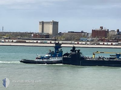
KAREN ANDRIE
Tug
Current Trip
| Time Travelled | 16 h, 22 mins |
|---|---|
| Remaining Time | 22 h, 55 mins |
| Distance Travelled | 0.15 nm |
| Remaining Distance | 364.15 nm |
| AVG Speed | --- |
| MAX Speed | --- |
| AVG Wind | 4.9 knots |
| MAX Wind | 5.8 knots |
| MIN Temp | -4.5°C / 23.9°F |
| MAX Temp | -2.5°C / 27.5°F |
| Draught | 5.1 m |
| Position Received | 15 h, 35 m ago |
Current Position
| Longitude | --- |
|---|---|
| Latitude | --- |
| Status | Moored |
| Speed | |
| Course | 269° |
| Area | --- |
| Station | T-AIS |
| Position Received | 15 h, 35 m ago |
Info
Information
The current position of KAREN ANDRIE is in --- with coordinates 41.64676° / -87.47522° as reported on 2026-01-03 14:01 by AIS to our vessel tracker app. The vessel's current speed is 0 Knots and is heading at the port of SAULT STE MARIE. The estimated time of arrival as calculated by MyShipTracking vessel tracking app is 2026-01-04 23:31 LT
The vessel KAREN ANDRIE (IMO: 6520454, MMSI: 366937150) is a Tug that was built in 1965 ( 61 years old ). It's sailing under the flag of [US] USA.
In this page you can find informations about the vessels current position, last detected port calls, and current voyage information. If the vessels is not in coverage by AIS you will find the latest position.
The current position of KAREN ANDRIE is detected by our AIS receivers and we are not responsible for the reliability of the data. The last position was recorded while the vessel was in Coverage by the Ais receivers of our vessel tracking app.
The current draught of KAREN ANDRIE as reported by AIS is 5.1 meters
Weather
| Temperature | -4°C / 24.8°F |
|---|---|
| Wind Speed | 6 knots |
| Direction | 304° NW |
| Pressure | 1020.5 hPa |
| Humidity | 66.8 % |
| Cloud Coverage | 77 % |
Featured Company
Last Port Calls
| Port | Arrival | Departure | Time In Port |
|---|---|---|---|
| 2026-01-03 06:29 | 2026-01-03 07:14 | 44 m | |
| 2025-12-28 03:18 | 2025-12-30 09:46 | 2 d | |
| 2025-12-25 00:40 | 2025-12-25 03:11 | 2 h | |
| 2025-12-23 07:43 | 2025-12-23 08:11 | 28 m | |
| 2025-12-22 13:35 | 2025-12-22 17:23 | 3 h | |
| 2025-12-18 17:51 | 2025-12-19 05:19 | 11 h | |
| 2025-12-18 01:08 | 2025-12-18 09:36 | 8 h | |
| 2025-12-15 13:07 | 2025-12-16 02:47 | 13 h | |
| 2025-12-15 01:31 | 2025-12-15 04:43 | 3 h | |
| 2025-12-14 01:07 | 2025-12-14 06:51 | 5 h |
Most Visited Ports (Last year)
| Port | Arrivals | |
|---|---|---|
| 38 | ||
| 35 | ||
| 9 | ||
| 8 | ||
| 3 | ||
| 2 |
Last Trips
| Origin | Departure | Destination | Arrival | Distance | |
|---|---|---|---|---|---|
| 2025-12-30 09:46 | 2026-01-03 06:29 | 651.28 nm | |||
| 2025-12-25 03:11 | 2025-12-28 03:18 | 620.38 nm | |||
| 2025-12-23 08:11 | 2025-12-25 00:40 | 8.60 nm | |||
| 2025-12-22 17:23 | 2025-12-23 07:43 | 1.66 nm | |||
| 2025-12-19 05:19 | 2025-12-22 13:35 | 97.39 nm | |||
| 2025-12-18 09:36 | 2025-12-18 17:51 | 86.59 nm | |||
| 2025-12-16 02:47 | 2025-12-18 01:08 | 90.43 nm | |||
| 2025-12-15 04:43 | 2025-12-15 13:07 | 86.92 nm | |||
| 2025-12-14 06:51 | 2025-12-15 01:31 | 1.40 nm | |||
| 2025-12-11 14:31 | 2025-12-14 01:07 | 604.59 nm |
Events
| Time | Event | Details | Position / Dest | Info |
|---|---|---|---|---|
| 2026-01-03 14:04 | Status Changed | Default Moored |
41.64674 / -87.47529
IND HBR
|
Speed: Course: 269° |
| 2026-01-03 14:01 | Status Changed | Moored Default |
41.64676 / -87.47522
IND HBR
|
Speed: Course: 269° |
| 2026-01-03 14:01 | OUT of Coverage |
41.64676 / -87.47522
|
Speed: Course: 271.6° |
|
| 2026-01-03 13:52 | IN Coverage |
41.64676 / -87.47522
|
Speed: Course: 271.6° |
|
| 2026-01-03 13:46 | STOP Moving | 2.13 nm, South West of INDIANA HARBOR |
41.64674 / -87.47529
IND HBR
|
Speed: Course: 269° |
| 2026-01-03 13:14 | PORT DEPARTURE |
|
41.65155 / -87.46432
IND HBR
|
Speed: 5.3 kn Course: 225° |
| 2026-01-03 13:10 | START Moving |
41.65542 / -87.45896
[US] INDIANA HARBOR
|
Speed: 5.3 kn Course: 225° |
|
| 2026-01-03 12:34 | STOP Moving |
41.66228 / -87.44923
[US] INDIANA HARBOR
|
Speed: 0.1 kn Course: 226° |
|
| 2026-01-03 12:29 | PORT ARRIVAL |
|
41.66248 / -87.44898
[US] INDIANA HARBOR
|
Speed: 0.6 kn Course: 226° |
| 2026-01-03 11:55 | OUT of Coverage |
41.70962 / -87.44931
[US] INDIANA HARBOR
|
Speed: 8.8 kn Course: 176.7° |