
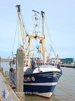
IJM8 RONY
Fishing Vessel
Current Trip
FISHING GROUNDS
| Time Travelled | 1 day |
|---|---|
| Remaining Time | --- |
| Distance Travelled | 123.11 nm |
| Remaining Distance | --- |
| AVG Speed | 8.1 Knots |
| MAX Speed | 10.7 Knots |
| AVG Wind | 13.5 knots |
| MAX Wind | 19 knots |
| MIN Temp | 8°C / 46.4°F |
| MAX Temp | 11.9°C / 53.42°F |
| Draught | 2.3 m |
| Position Received | 3 h, 26 m ago |
Current Position
| Longitude | --- |
|---|---|
| Latitude | --- |
| Status | Engaged in Fishing |
| Speed | 3.2 Knots |
| Course | 43° |
| Area | North Sea |
| Station | T-AIS |
| Position Received | 3 h, 26 m ago |
Info
Information
The current position of IJM8 RONY is in North Sea with coordinates 51.40994° / 2.08839° as reported on 2025-12-12 15:21 by AIS to our vessel tracker app. The vessel's current speed is 3.2 Knots
The vessel IJM8 RONY (IMO: 8431683, MMSI: 246206000) is a Fishing Vessel that was built in 1986 ( 39 years old ). It's sailing under the flag of [NL] Netherlands.
In this page you can find informations about the vessels current position, last detected port calls, and current voyage information. If the vessels is not in coverage by AIS you will find the latest position.
The current position of IJM8 RONY is detected by our AIS receivers and we are not responsible for the reliability of the data. The last position was recorded while the vessel was in Coverage by the Ais receivers of our vessel tracking app.
The current draught of IJM8 RONY as reported by AIS is 2.3 meters
Weather
| Temperature | 11.9°C / 53.42°F |
|---|---|
| Wind Speed | 19 knots |
| Direction | 204° SSW |
| Pressure | 1018.7 hPa |
| Humidity | 89.2 % |
| Cloud Coverage | 100 % |
Featured Company
Last Port Calls
| Port | Arrival | Departure | Time In Port |
|---|---|---|---|
| 2025-12-10 21:20 | 2025-12-11 19:38 | 22 h | |
| 2025-12-05 22:00 | 2025-12-08 00:49 | 2 d | |
| 2025-12-01 06:36 | 2025-12-04 20:26 | 3 d | |
| 2025-11-22 09:02 | 2025-11-26 01:15 | 3 d | |
| 2025-11-11 14:36 | 2025-11-12 15:11 | 1 d | |
| 2025-10-20 23:44 | 2025-10-29 07:14 | 8 d | |
| 2025-10-16 20:27 | 2025-10-19 23:41 | 3 d | |
| 2025-10-15 12:39 | 2025-10-15 13:11 | 31 m | |
| 2025-10-14 08:01 | 2025-10-14 13:39 | 5 h | |
| 2025-10-10 05:51 | 2025-10-13 00:06 | 2 d |
Most Visited Ports (Last year)
| Port | Arrivals | |
|---|---|---|
| 49 | ||
| 6 | ||
| 3 | ||
| 3 | ||
| 3 | ||
| 2 |
Last Trips
| Origin | Departure | Destination | Arrival | Distance | |
|---|---|---|---|---|---|
| 2025-12-08 00:49 | 2025-12-10 21:20 | 306.89 nm | |||
| 2025-12-04 20:26 | 2025-12-05 22:00 | 156.09 nm | |||
| 2025-11-26 01:15 | 2025-12-01 06:36 | 525.23 nm | |||
| 2025-11-12 15:11 | 2025-11-22 09:02 | 196.43 nm | |||
| 2025-10-29 07:14 | 2025-11-11 14:36 | 664.64 nm | |||
| 2025-10-19 23:41 | 2025-10-20 23:44 | 121.85 nm | |||
| 2025-10-15 13:11 | 2025-10-16 20:27 | 149.96 nm | |||
| 2025-10-14 13:39 | 2025-10-15 12:39 | 119.94 nm | |||
| 2025-10-13 00:06 | 2025-10-14 08:01 | 156.32 nm | |||
| 2025-10-06 09:36 | 2025-10-10 05:51 | 355.90 nm |
Events
| Time | Event | Details | Position / Dest | Info |
|---|---|---|---|---|
| 2025-12-12 15:21 | OUT of Coverage |
51.40994 / 2.08839
North Sea
|
Speed: 3.2 kn Course: 44.1° |
|
| 2025-12-12 14:58 | Change Sea Area | French part of the North Sea United Kingdom part of the North Sea |
51.39670 / 2.06892
North Sea
|
Speed: 1.4 kn Course: 50.7° |
| 2025-12-12 14:38 | START Moving |
51.39131 / 2.05954
FISHING GROUNDS
|
Speed: 3.2 kn Course: 48° |
|
| 2025-12-12 14:35 | STOP Moving |
51.39094 / 2.05667
FISHING GROUNDS
|
Speed: 0.3 kn Course: 52° |
|
| 2025-12-12 14:25 | Change Sea Area | United Kingdom part of the North Sea French part of the North Sea |
51.39366 / 2.06592
North Sea
|
Speed: 1.8 kn Course: 224.4° |
| 2025-12-12 12:20 | Change Sea Area | French part of the North Sea Belgian part of the North Sea |
51.49133 / 2.18401
North Sea
|
Speed: 3.7 kn Course: 213.2° |
| 2025-12-12 12:19 | IN Coverage |
51.49133 / 2.18401
North Sea
|
Speed: 3.7 kn Course: 213.2° |
|
| 2025-12-12 05:14 | OUT of Coverage |
51.48499 / 2.68630
North Sea
|
Speed: 8.4 kn Course: 271.5° |
|
| 2025-12-12 03:23 | Change Sea Area | Belgian part of the North Sea Dutch part of the North Sea |
51.53674 / 3.10306
North Sea
|
Speed: 9.8 kn Course: 222.5° |
| 2025-12-12 00:31 | IN Coverage |
51.88401 / 3.56731
North Sea
|
Speed: 10.2 kn Course: 228.4° |