
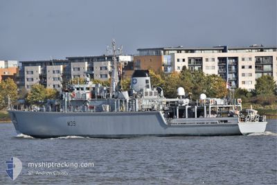
HMS HURWORTH
Tug
Current Trip
MARITIME SECURITY
| Time Travelled | 6 days |
|---|---|
| Remaining Time | --- |
| Distance Travelled | 651.58 nm |
| Remaining Distance | --- |
| AVG Speed | 10.6 Knots |
| MAX Speed | 16.6 Knots |
| AVG Wind | 10 knots |
| MAX Wind | 19.8 knots |
| MIN Temp | 11.1°C / 51.98°F |
| MAX Temp | 15.7°C / 60.26°F |
| Draught | 3.2 m |
| Position Received | 3 d ago |
Current Position
| Longitude | -1.11129° |
|---|---|
| Latitude | 50.79176° |
| Status | Under way using engine |
| Speed | 7.5 Knots |
| Course | 345.3° |
| Area | English Channel |
| Station | T-AIS |
| Position Received | 3 d ago |
Info
Information
The current position of HMS HURWORTH is in English Channel with coordinates 50.79176° / -1.11129° as reported on 2024-05-29 11:50 by AIS to our vessel tracker app. The vessel's current speed is 7.5 Knots
The vessel HMS HURWORTH (IMO: 8401509, MMSI: 234600000) is a Tug that was built in 1986 ( 38 years old ). It's sailing under the flag of [GB] United Kingdom.
In this page you can find informations about the vessels current position, last detected port calls, and current voyage information. If the vessels is not in coverage by AIS you will find the latest position.
The current position of HMS HURWORTH is detected by our AIS receivers and we are not responsible for the reliability of the data. The last position was recorded while the vessel was in Coverage by the Ais receivers of our vessel tracking app.
The current draught of HMS HURWORTH as reported by AIS is 3.2 meters
Weather
| Temperature | 15.7°C / 60.26°F |
|---|---|
| Wind Speed | 12 knots |
| Direction | 240° WSW |
| Pressure | 1010.3 hPa |
| Humidity | 73.6 % |
| Cloud Coverage | 36 % |
Featured Company
Last Port Calls
| Port | Arrival | Departure | Time In Port |
|---|---|---|---|
| 2024-05-25 18:56 | 2024-05-25 20:51 | 1 h | |
| 2024-05-21 11:56 | 2024-05-24 08:09 | 2 d | |
| 2024-05-21 00:25 | |||
| 2024-05-18 11:47 | |||
| 2024-05-09 17:50 | 2024-05-14 15:59 | 4 d | |
| 2024-05-07 18:02 | 2024-05-08 08:06 | 14 h | |
| 2024-05-06 15:49 | 2024-05-07 08:21 | 16 h | |
| 2024-05-03 14:11 | 2024-05-06 13:31 | 2 d | |
| 2024-05-02 16:24 | 2024-05-03 07:59 | 15 h | |
| 2024-04-30 18:07 | 2024-05-01 07:59 | 13 h |
Most Visited Ports (Last year)
| Port | Arrivals | |
|---|---|---|
| 22 | ||
| 16 | ||
| 12 | ||
| 3 | ||
| 1 | ||
| 1 |
Last Trips
| Origin | Departure | Destination | Arrival | Distance | |
|---|---|---|---|---|---|
| 2024-05-24 08:09 | 2024-05-25 18:56 | 107.41 nm | |||
| 2024-05-21 00:25 | 2024-05-21 11:56 | 55.31 nm | |||
| 2024-05-08 08:06 | 2024-05-09 17:50 | 169.23 nm | |||
| 2024-05-07 08:21 | 2024-05-07 18:02 | 36.19 nm | |||
| 2024-05-06 13:31 | 2024-05-06 15:49 | 1.58 nm | |||
| 2024-05-03 07:59 | 2024-05-03 14:11 | 29.76 nm | |||
| 2024-05-01 07:59 | 2024-05-02 16:24 | 89.09 nm | |||
| 2024-04-30 09:57 | 2024-04-30 18:07 | 41.57 nm | |||
| 2024-04-29 09:48 | 2024-04-29 16:47 | 41.96 nm | |||
| 2024-04-25 09:04 | 2024-04-25 16:28 | 19.63 nm |
Events
| Time | Event | Details | Position / Dest | Info |
|---|---|---|---|---|
| 2024-05-29 11:50 | OUT of Coverage |
50.79176 / -1.11129
English Channel
|
Speed: 7.5 kn Course: 345.3° |
|
| 2024-05-29 08:54 | IN Coverage |
50.54601 / -1.19703
English Channel
|
Speed: 14.8 kn Course: 36.3° |
|
| 2024-05-29 05:54 | OUT of Coverage |
50.37360 / -2.13189
English Channel
|
Speed: 10.2 kn Course: 67.9° |
|
| 2024-05-29 03:09 | IN Coverage |
50.23689 / -2.95477
English Channel
|
Speed: 13.9 kn Course: 79.5° |
|
| 2024-05-29 01:39 | OUT of Coverage |
50.14682 / -3.47457
English Channel
|
Speed: 14.3 kn Course: 72° |
|
| 2024-05-28 21:08 | Change Sea Area | United Kingdom part of the English Channel United Kingdom part of the Celtic Sea |
49.91914 / -5.07702
English Channel
|
Speed: 14.8 kn Course: 79.2° |
| 2024-05-28 21:05 | IN Coverage |
49.91914 / -5.07702
English Channel
|
Speed: 14.8 kn Course: 79.2° |
|
| 2024-05-28 18:34 | OUT of Coverage |
49.93602 / -6.00913
Celtic Sea
|
Speed: 12.7 kn Course: 174.8° |
|
| 2024-05-28 17:19 | Detected in Sea | United Kingdom part of the Celtic Sea |
50.19637 / -6.00208
Celtic Sea
|
Speed: 12.7 kn Course: 175.9° |
| 2024-05-28 17:19 | IN Coverage |
50.19637 / -6.00208
Celtic Sea
|
Speed: 12.7 kn Course: 175.9° |