
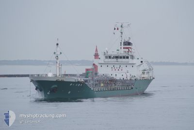
HASSHO MARU NO.1
Tanker
Current Trip
>JP IIDA WAN OFF
| Time Travelled | 3 h, 50 mins |
|---|---|
| Remaining Time | --- |
| Distance Travelled | 12.03 nm |
| Remaining Distance | --- |
| AVG Speed | 12 Knots |
| MAX Speed | 15 Knots |
| AVG Wind | 3.1 knots |
| MAX Wind | 4 knots |
| MIN Temp | 10.5°C / 50.9°F |
| MAX Temp | 10.9°C / 51.62°F |
| Draught | 5 m |
| Position Received | 4 d ago |
Current Position
| Longitude | --- |
|---|---|
| Latitude | --- |
| Status | Under way using engine |
| Speed | 14.3 Knots |
| Course | 249.3° |
| Area | Japan Sea |
| Station | T-AIS |
| Position Received | 4 d ago |
Info
Information
The current position of HASSHO MARU NO.1 is in Japan Sea with coordinates 37.52640° / 137.04397° as reported on 2025-12-05 21:48 by AIS to our vessel tracker app. The vessel's current speed is 14.3 Knots
The vessel HASSHO MARU NO.1 (IMO: 9254226, MMSI: 431501712) is a Tanker It's sailing under the flag of [JP] Japan.
In this page you can find informations about the vessels current position, last detected port calls, and current voyage information. If the vessels is not in coverage by AIS you will find the latest position.
The current position of HASSHO MARU NO.1 is detected by our AIS receivers and we are not responsible for the reliability of the data. The last position was recorded while the vessel was in Coverage by the Ais receivers of our vessel tracking app.
The current draught of HASSHO MARU NO.1 as reported by AIS is 5 meters
Weather
| Temperature | 10.1°C / 50.18°F |
|---|---|
| Wind Speed | 3 knots |
| Direction | 144° SE |
| Pressure | 1023.8 hPa |
| Humidity | 48.1 % |
| Cloud Coverage | 100 % |
Featured Company
Last Port Calls
| Port | Arrival | Departure | Time In Port |
|---|---|---|---|
| 2025-12-09 09:45 | 2025-12-10 11:53 | 1 d | |
| 2025-12-08 12:09 | 2025-12-09 07:49 | 19 h | |
| 2025-11-30 12:17 | 2025-11-30 18:13 | 5 h | |
| 2025-11-25 08:35 | 2025-11-26 15:12 | 1 d | |
| 2025-11-23 10:12 | 2025-11-23 17:53 | 7 h | |
| 2025-11-22 08:14 | 2025-11-22 12:21 | 4 h | |
| 2025-11-20 08:39 | 2025-11-20 11:40 | 3 h | |
| 2025-11-16 10:40 | 2025-11-16 17:36 | 6 h | |
| 2025-11-14 07:54 | 2025-11-15 07:54 | 23 h | |
| 2025-11-13 08:32 | 2025-11-13 13:48 | 5 h |
Last Trips
| Origin | Departure | Destination | Arrival | Distance | |
|---|---|---|---|---|---|
| 2025-12-09 07:49 | 2025-12-09 09:45 | 14.58 nm | |||
| 2025-11-30 18:13 | 2025-12-08 12:09 | 999.60 nm | |||
| 2025-11-26 15:12 | 2025-11-30 12:17 | 378.81 nm | |||
| 2025-11-23 17:53 | 2025-11-25 08:35 | 313.86 nm | |||
| 2025-11-22 12:21 | 2025-11-23 10:12 | 219.69 nm | |||
| 2025-11-20 11:40 | 2025-11-22 08:14 | 221.85 nm | |||
| 2025-11-16 17:36 | 2025-11-20 08:39 | 570.89 nm | |||
| 2025-11-15 07:54 | 2025-11-16 10:40 | 391.71 nm | |||
| 2025-11-13 13:48 | 2025-11-14 07:54 | 60.71 nm | |||
| 2025-11-10 14:48 | 2025-11-13 08:32 | 138.20 nm |
Events
| Time | Event | Details | Position / Dest | Info |
|---|---|---|---|---|
| 2025-12-10 04:01 | STOP Moving | 1.75 nm, North West of ATATA |
34.20880 / 132.28348
>JP IIDA WAN OFF
|
Speed: 0.2 kn Course: 230° |
| 2025-12-10 02:53 | PORT DEPARTURE |
|
34.31755 / 132.48065
>JP IIDA WAN OFF
|
Speed: 3.5 kn Course: 200° |
| 2025-12-10 02:33 | START Moving |
34.33825 / 132.49008
[JP] HIROSHIMA
|
Speed: 6.2 kn Course: 180° |
|
| 2025-12-09 01:05 | STOP Moving |
34.34098 / 132.48610
[JP] HIROSHIMA
|
Speed: 0.1 kn Course: 220° |
|
| 2025-12-09 00:45 | START Moving |
34.32442 / 132.48634
[JP] HIROSHIMA
|
Speed: 5.6 kn Course: 12° |
|
| 2025-12-09 00:45 | PORT ARRIVAL |
|
34.32442 / 132.48634
[JP] HIROSHIMA
|
Speed: 1.1 kn Course: 14° |
| 2025-12-09 00:37 | STOP Moving | 4.17 nm, South East of HIROSHIMA |
34.31943 / 132.48491
>JP IIDA WAN OFF
|
Speed: 0.3 kn Course: 19° |
| 2025-12-08 22:49 | PORT DEPARTURE |
|
34.19225 / 132.24878
>JP IIDA WAN OFF
|
Speed: 5.7 kn Course: 86° |
| 2025-12-08 22:45 | START Moving |
34.19198 / 132.23938
[JP] IWAKUNI
|
Speed: 5.7 kn Course: 86° |
|
| 2025-12-08 03:13 | STOP Moving |
34.18955 / 132.23607
[JP] IWAKUNI
|
Speed: 0.3 kn Course: 57° |