
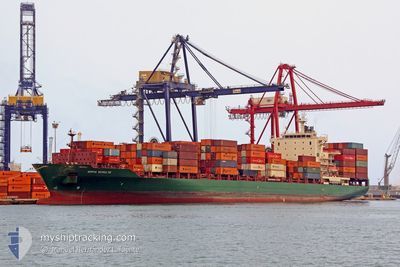
GSL MERCER
Container Ship
Current Trip
| Time Travelled | 1 day |
|---|---|
| Remaining Time | --- |
| Distance Travelled | 205.32 nm |
| Remaining Distance | --- |
| AVG Speed | 9.2 Knots |
| MAX Speed | 15.8 Knots |
| AVG Wind | 21.9 knots |
| MAX Wind | 35 knots |
| MIN Temp | 7.7°C / 45.86°F |
| MAX Temp | 13.1°C / 55.58°F |
| Draught | 11.9 m |
| Position Received | 1 m ago |
Current Position
| Longitude | --- |
|---|---|
| Latitude | --- |
| Status | Under way using engine |
| Speed | 3.9 Knots |
| Course | 245° |
| Area | English Channel |
| Station | T-AIS |
| Position Received | 1 m ago |
Info
Information
The current position of GSL MERCER is in English Channel with coordinates 50.42670° / -0.29261° as reported on 2025-12-18 19:33 by AIS to our vessel tracker app. The vessel's current speed is 3.9 Knots and is heading at the port of ALEXANDRIA. The estimated time of arrival as calculated by MyShipTracking vessel tracking app is 2025-12-26 09:30 LT
The vessel GSL MERCER (IMO: 9337274, MMSI: 636018378) is a Container Ship that was built in 2007 ( 18 years old ). It's sailing under the flag of [LR] Liberia.
In this page you can find informations about the vessels current position, last detected port calls, and current voyage information. If the vessels is not in coverage by AIS you will find the latest position.
The current position of GSL MERCER is detected by our AIS receivers and we are not responsible for the reliability of the data. The last position was recorded while the vessel was in Coverage by the Ais receivers of our vessel tracking app.
The current draught of GSL MERCER as reported by AIS is 11.9 meters
Weather
| Temperature | 12.8°C / 55.04°F |
|---|---|
| Wind Speed | 32 knots |
| Direction | 214° SW |
| Pressure | 1004.3 hPa |
| Humidity | 86.9 % |
| Cloud Coverage | 100 % |
Featured Company
Last Port Calls
| Port | Arrival | Departure | Time In Port |
|---|---|---|---|
| 2025-12-17 02:22 | 2025-12-17 18:36 | 16 h | |
| 2025-12-14 21:10 | 2025-12-15 08:20 | 11 h | |
| 2025-12-12 11:37 | 2025-12-13 06:21 | 18 h | |
| 2025-12-12 11:34 | |||
| 2025-12-12 08:28 | |||
| 2025-12-12 08:25 | |||
| 2025-12-12 08:06 | |||
| 2025-12-12 08:06 | |||
| 2025-12-12 08:02 | |||
| 2025-12-12 07:59 |
Most Visited Ports (Last year)
| Port | Arrivals | |
|---|---|---|
| 11 | ||
| 10 | ||
| 10 | ||
| 9 | ||
| 8 | ||
| 8 |
Last Trips
| Origin | Departure | Destination | Arrival | Distance | |
|---|---|---|---|---|---|
| 2025-12-15 08:20 | 2025-12-17 02:22 | 441.38 nm | |||
| 2025-12-13 06:21 | 2025-12-14 21:10 | 362.71 nm | |||
| 2025-12-10 22:08 | 2025-12-12 11:37 | 282.06 nm | |||
| 2025-12-10 22:08 | 2025-12-12 11:34 | 282.00 nm | |||
| 2025-12-10 22:08 | 2025-12-12 08:28 | 281.90 nm | |||
| 2025-12-10 22:08 | 2025-12-12 08:25 | 281.87 nm | |||
| 2025-12-10 22:08 | 2025-12-12 08:06 | 281.79 nm | |||
| 2025-12-10 22:08 | 2025-12-12 08:06 | 281.79 nm | |||
| 2025-12-10 22:08 | 2025-12-12 08:02 | 281.73 nm | |||
| 2025-12-10 22:08 | 2025-12-12 07:59 | 281.61 nm |
Events
| Time | Event | Details | Position / Dest | Info |
|---|---|---|---|---|
| 2025-12-18 16:42 | Status Changed | Under way using engine Default |
50.48303 / .01306
EGALY
|
Speed: 6.4 kn Course: 257° |
| 2025-12-18 16:26 | Status Changed | Default Under way using engine |
50.49073 / .05845
EGALY
|
Speed: 7 kn Course: 254.4° |
| 2025-12-18 16:15 | Status Changed | Under way using engine Default |
50.49569 / .08829
EGALY
|
Speed: 7 kn Course: 255° |
| 2025-12-18 16:06 | Status Changed | Default Under way using engine |
50.50042 / .11678
EGALY
|
Speed: 7.1 kn Course: 254.5° |
| 2025-12-18 15:57 | Status Changed | Under way using engine Default |
50.50483 / .14436
EGALY
|
Speed: 7.1 kn Course: 255° |
| 2025-12-18 15:42 | IN Coverage |
50.50468 / .14335
English Channel
EGALY
|
Speed: 7.2 kn Course: 258.1° |
|
| 2025-12-18 14:06 | Status Changed | Default Under way using engine |
50.56739 / .50990
EGALY
|
Speed: 8.2 kn Course: 256.7° |
| 2025-12-18 13:59 | OUT of Coverage |
50.57098 / .53444
English Channel
EGALY
|
Speed: 8.2 kn Course: 256.7° |
|
| 2025-12-18 13:56 | Status Changed | Under way using engine Default |
50.57224 / .54257
EGALY
|
Speed: 8.4 kn Course: 257° |
| 2025-12-18 13:54 | Status Changed | Default Under way using engine |
50.57352 / .55211
EGALY
|
Speed: 8.3 kn Course: 257.5° |