
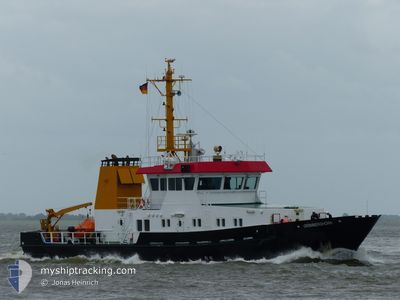
GRIMMERSHOERN
Other Type
Current Trip
| Trip Time | 8 h, 8 mins |
|---|---|
| Trip Distance | 73.25 nm |
| AVG Speed | 9.7 Knots |
| MAX Speed | 9.7 Knots |
| Draught | 3.2 m |
| AVG Wind | 13.4 knots |
| MAX Wind | 16.8 knots |
| MIN Temp | 8.1°C / 46.58°F |
| MAX Temp | 9°C / 48.2°F |
| Position Received | 5 m ago |
Current Position
| Longitude | --- |
|---|---|
| Latitude | --- |
| Status | Moored |
| Speed | 0.1 Knots |
| Course | 301° |
| Area | North Sea |
| Station | T-AIS |
| Position Received | 5 m ago |
Info
Information
The current position of GRIMMERSHOERN is in North Sea with coordinates 53.87054° / 8.70811° as reported on 2025-12-11 15:20 by AIS to our vessel tracker app. The vessel's current speed is 0.1 Knots and is currently inside the port of CUXHAVEN.
The vessel GRIMMERSHOERN (IMO: 9586174, MMSI: 218356000) is a Other Type It's sailing under the flag of [DE] Germany.
In this page you can find informations about the vessels current position, last detected port calls, and current voyage information. If the vessels is not in coverage by AIS you will find the latest position.
The current position of GRIMMERSHOERN is detected by our AIS receivers and we are not responsible for the reliability of the data. The last position was recorded while the vessel was in Coverage by the Ais receivers of our vessel tracking app.
The current draught of GRIMMERSHOERN as reported by AIS is 3.2 meters
Weather
| Temperature | 8.1°C / 46.58°F |
|---|---|
| Wind Speed | 13 knots |
| Direction | 226° SW |
| Pressure | 1019.3 hPa |
| Humidity | 88.4 % |
| Cloud Coverage | 100 % |
Featured Company
Last Port Calls
| Port | Arrival | Departure | Time In Port |
|---|---|---|---|
| 2025-12-11 15:09 | |||
| 2025-12-10 15:07 | 2025-12-11 07:01 | 15 h | |
| 2025-12-09 15:15 | 2025-12-10 07:04 | 15 h | |
| 2025-12-08 15:28 | 2025-12-09 06:59 | 15 h | |
| 2025-12-04 13:53 | 2025-12-08 07:05 | 3 d | |
| 2025-12-03 15:06 | 2025-12-04 07:03 | 15 h | |
| 2025-12-02 15:22 | 2025-12-03 07:01 | 15 h | |
| 2025-11-21 08:10 | 2025-12-02 07:42 | 10 d | |
| 2025-11-20 15:07 | 2025-11-21 06:59 | 15 h | |
| 2025-11-17 15:07 | 2025-11-20 07:11 | 2 d |
Last Trips
| Origin | Departure | Destination | Arrival | Distance | |
|---|---|---|---|---|---|
| 2025-12-11 07:01 | 2025-12-11 15:09 | 73.25 nm | |||
| 2025-12-10 07:04 | 2025-12-10 15:07 | 85.15 nm | |||
| 2025-12-09 06:59 | 2025-12-09 15:15 | 71.57 nm | |||
| 2025-12-08 07:05 | 2025-12-08 15:28 | 81.74 nm | |||
| 2025-12-04 07:03 | 2025-12-04 13:53 | 63.59 nm | |||
| 2025-12-03 07:01 | 2025-12-03 15:06 | 68.56 nm | |||
| 2025-12-02 07:42 | 2025-12-02 15:22 | 72.15 nm | |||
| 2025-11-21 06:59 | 2025-11-21 08:10 | 7.26 nm | |||
| 2025-11-20 07:11 | 2025-11-20 15:07 | 90.00 nm | |||
| 2025-11-17 07:09 | 2025-11-17 15:07 | 89.45 nm |
Events
| Time | Event | Details | Position / Dest | Info |
|---|---|---|---|---|
| 2025-12-11 15:17 | Status Changed | Moored Default |
53.87054 / 8.70811
[DE] CUXHAVEN
|
Speed: Course: 301° |
| 2025-12-11 15:10 | IN Coverage |
53.87054 / 8.70811
North Sea
[DE] CUXHAVEN
|
Speed: 0.1 kn Course: 7° |
|
| 2025-12-11 14:16 | STOP Moving |
53.87056 / 8.70811
[DE] CUXHAVEN
|
Speed: 0.1 kn Course: 302° |
|
| 2025-12-11 14:09 | PORT ARRIVAL |
|
53.87109 / 8.71167
[DE] CUXHAVEN
|
Speed: 12.2 kn Course: 295° |
| 2025-12-11 14:01 | Status Changed | Default Restricted manoeuverability |
53.85983 / 8.74850
DE CUX
|
Speed: 12.4 kn Course: 305° |
| 2025-12-11 13:54 | Status Changed | Restricted manoeuverability Default |
53.84685 / 8.78184
DE CUX
|
Speed: 12.4 kn Course: 289° |
| 2025-12-11 13:54 | OUT of Coverage |
53.84685 / 8.78184
North Sea
[DE] CUXHAVEN
|
Speed: 12.4 kn Course: 305° |
|
| 2025-12-11 13:49 | Status Changed | Default Restricted manoeuverability |
53.84336 / 8.81030
DE CUX
|
Speed: 13.2 kn Course: 265° |
| 2025-12-11 11:48 | START Moving | 3.45 nm, North of NEUHAUS |
53.86133 / 9.03600
DE CUX
|
Speed: 4.1 kn Course: 141° |
| 2025-12-11 11:44 | STOP Moving | 3.49 nm, North of NEUHAUS |
53.86217 / 9.04033
DE CUX
|
Speed: 0.3 kn Course: 95° |