
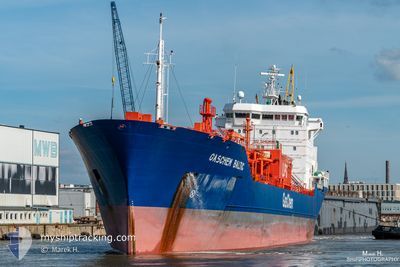
GASCHEM BALTIC
Lpg Tanker
Current Trip
| Time Travelled | 22 h, 51 mins |
|---|---|
| Remaining Time | 1 day |
| Distance Travelled | 279.58 nm |
| Remaining Distance | 402.32 nm |
| AVG Speed | 12.9 Knots |
| MAX Speed | 13.9 Knots |
| AVG Wind | 14.6 knots |
| MAX Wind | 27 knots |
| MIN Temp | 15.5°C / 59.9°F |
| MAX Temp | 16.6°C / 61.88°F |
| Draught | 7.7 m |
| Position Received | 1 h, 1 m ago |
Current Position
| Longitude | --- |
|---|---|
| Latitude | --- |
| Status | Under way using engine |
| Speed | 13.1 Knots |
| Course | 333.6° |
| Area | Adriatic Sea |
| Station | T-AIS |
| Position Received | 1 h, 1 m ago |
Info
Information
The current position of GASCHEM BALTIC is in Adriatic Sea with coordinates 40.62930° / 18.46703° as reported on 2025-03-14 05:55 by AIS to our vessel tracker app. The vessel's current speed is 13.1 Knots and is heading at the port of VENEZIA. The estimated time of arrival as calculated by MyShipTracking vessel tracking app is 2025-03-15 13:30 LT
The vessel GASCHEM BALTIC (IMO: 9269269, MMSI: 255802780) is a Lpg Tanker that was built in 2004 ( 21 years old ). It's sailing under the flag of [PT] Portugal.
In this page you can find informations about the vessels current position, last detected port calls, and current voyage information. If the vessels is not in coverage by AIS you will find the latest position.
The current position of GASCHEM BALTIC is detected by our AIS receivers and we are not responsible for the reliability of the data. The last position was recorded while the vessel was in Coverage by the Ais receivers of our vessel tracking app.
The current draught of GASCHEM BALTIC as reported by AIS is 7.7 meters
Weather
| Temperature | 15.6°C / 60.08°F |
|---|---|
| Wind Speed | 28 knots |
| Direction | 164° SSE |
| Pressure | 1009.8 hPa |
| Humidity | 84.6 % |
| Cloud Coverage | 66 % |
Featured Company
Last Port Calls
| Port | Arrival | Departure | Time In Port |
|---|---|---|---|
| 2025-03-12 01:37 | 2025-03-13 09:05 | 1 d | |
| 2025-03-09 16:33 | 2025-03-11 02:21 | 1 d | |
| 2025-03-06 16:26 | 2025-03-08 10:04 | 1 d | |
| 2025-02-25 15:17 | 2025-03-01 20:33 | 4 d | |
| 2025-02-21 16:27 | 2025-02-23 09:03 | 1 d | |
| 2025-02-14 08:41 | 2025-02-19 09:09 | 5 d | |
| 2025-02-10 10:59 | 2025-02-12 00:08 | 1 d | |
| 2025-02-04 06:55 | 2025-02-06 05:52 | 1 d | |
| 2025-01-27 13:02 | 2025-01-29 16:29 | 2 d | |
| 2025-01-19 15:01 | 2025-01-24 21:05 | 5 d |
Last Trips
| Origin | Departure | Destination | Arrival | Distance | |
|---|---|---|---|---|---|
| 2025-03-11 02:21 | 2025-03-12 01:37 | 297.46 nm | |||
| 2025-03-08 10:04 | 2025-03-09 16:33 | 397.99 nm | |||
| 2025-03-01 20:33 | 2025-03-06 16:26 | 692.12 nm | |||
| 2025-02-23 09:03 | 2025-02-25 15:17 | 691.54 nm | |||
| 2025-02-19 09:09 | 2025-02-21 16:27 | 692.95 nm | |||
| 2025-02-12 00:08 | 2025-02-14 08:41 | 685.45 nm | |||
| 2025-02-06 05:52 | 2025-02-10 10:59 | 1044.86 nm | |||
| 2025-01-29 16:29 | 2025-02-04 06:55 | 1192.73 nm | |||
| 2025-01-24 21:05 | 2025-01-27 13:02 | 695.86 nm | |||
| 2025-01-17 09:39 | 2025-01-19 15:01 | 684.58 nm |
Events
| Time | Event | Details | Position / Dest | Info |
|---|---|---|---|---|
| 2025-03-14 06:29 | Status Changed | Default Under way using engine |
40.74284 / 18.39575
ITPMA
|
Speed: 13.1 kn Course: 333.6° |
| 2025-03-14 04:03 | Status Changed | Under way using engine Default |
40.26584 / 18.70661
ITPMA
|
Speed: 13 kn Course: 334° |
| 2025-03-14 03:58 | Status Changed | Default Under way using engine |
40.25017 / 18.72125
ITPMA
|
Speed: 13.6 kn Course: 322.2° |
| 2025-03-14 03:53 | Change Sea Area | Italian part of the Adriatic Sea Italian part of the Ionian Sea |
40.23794 / 18.73779
Adriatic Sea
ITPMA
|
Speed: 13.6 kn Course: 322.2° |
| 2025-03-14 03:53 | Status Changed | Under way using engine Default |
40.23794 / 18.73779
ITPMA
|
Speed: 13.6 kn Course: 332° |
| 2025-03-14 03:38 | IN Coverage |
40.23794 / 18.73779
Adriatic Sea
ITPMA
|
Speed: 13.6 kn Course: 322.2° |
|
| 2025-03-14 00:05 | Status Changed | Default Under way using engine |
39.50679 / 18.31358
ITPMA
|
Speed: 13.2 kn Course: 42.8° |
| 2025-03-13 23:59 | OUT of Coverage |
39.49176 / 18.29517
Ionian Sea
ITPMA
|
Speed: 13.2 kn Course: 42.8° |
|
| 2025-03-13 23:54 | Status Changed | Under way using engine Default |
39.47829 / 18.27873
ITPMA
|
Speed: 13.3 kn Course: 44° |
| 2025-03-13 23:45 | IN Coverage |
39.47924 / 18.27987
Ionian Sea
ITPMA
|
Speed: 13.3 kn Course: 42.8° |