
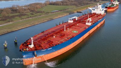
FRONT TWEED
Tanker
Current Trip
US GULF FOR ORDERS
| Time Travelled | 13 days |
|---|---|
| Remaining Time | --- |
| Distance Travelled | 3027.34 nm |
| Remaining Distance | --- |
| AVG Speed | 9.1 Knots |
| MAX Speed | 16.2 Knots |
| AVG Wind | 16.9 knots |
| MAX Wind | 44 knots |
| MIN Temp | 0.9°C / 33.62°F |
| MAX Temp | 21.7°C / 71.06°F |
| Draught | 11.5 m |
| Position Received | 5 d ago |
Current Position
| Longitude | --- |
|---|---|
| Latitude | --- |
| Status | Under way using engine |
| Speed | 9.3 Knots |
| Course | 248.6° |
| Area | North Atlantic Ocean |
| Station | T-AIS |
| Position Received | 5 d ago |
Info
Information
The current position of FRONT TWEED is in North Atlantic Ocean with coordinates 36.31877° / -31.70538° as reported on 2025-02-27 20:48 by AIS to our vessel tracker app. The vessel's current speed is 9.3 Knots
The vessel FRONT TWEED (IMO: 9920784, MMSI: 256298000) is a Tanker It's sailing under the flag of [MT] Malta.
In this page you can find informations about the vessels current position, last detected port calls, and current voyage information. If the vessels is not in coverage by AIS you will find the latest position.
The current position of FRONT TWEED is detected by our AIS receivers and we are not responsible for the reliability of the data. The last position was recorded while the vessel was in Coverage by the Ais receivers of our vessel tracking app.
The current draught of FRONT TWEED as reported by AIS is 11.5 meters
Weather
| Temperature | 17.6°C / 63.68°F |
|---|---|
| Wind Speed | 18 knots |
| Direction | 27° NNE |
| Pressure | 1024.5 hPa |
| Humidity | 62.7 % |
| Cloud Coverage | 100 % |
Featured Company
Last Port Calls
| Port | Arrival | Departure | Time In Port |
|---|---|---|---|
| 2025-02-16 17:01 | 2025-02-19 06:17 | 2 d | |
| 2025-01-22 10:51 | 2025-01-24 14:10 | 2 d |
Last Trips
| Origin | Departure | Destination | Arrival | Distance | |
|---|---|---|---|---|---|
| 2025-01-24 14:10 | 2025-02-16 17:01 | 5661.39 nm | |||
| 2024-12-10 17:05 | 2025-01-22 10:51 | 6350.48 nm |
Events
| Time | Event | Details | Position / Dest | Info |
|---|---|---|---|---|
| 2025-02-27 20:54 | Status Changed | Default Under way using engine |
36.31284 / -31.72329
US GULF FOR ORDERS
|
Speed: 9.3 kn Course: 248.6° |
| 2025-02-27 20:48 | Status Changed | Under way using engine Default |
36.31877 / -31.70538
US GULF FOR ORDERS
|
Speed: 9.4 kn Course: 250° |
| 2025-02-27 20:48 | OUT of Coverage |
36.31877 / -31.70538
North Atlantic Ocean
US GULF FOR ORDERS
|
Speed: 9.3 kn Course: 248.6° |
|
| 2025-02-27 20:29 | Status Changed | Default Under way using engine |
36.33543 / -31.64847
US GULF FOR ORDERS
|
Speed: 9.3 kn Course: 249.6° |
| 2025-02-27 19:57 | Status Changed | Under way using engine Default |
36.36505 / -31.55216
US GULF FOR ORDERS
|
Speed: 9.8 kn Course: 274° |
| 2025-02-27 19:57 | IN Coverage |
36.36505 / -31.55216
North Atlantic Ocean
US GULF FOR ORDERS
|
Speed: 9.3 kn Course: 249.3° |
|
| 2025-02-27 16:46 | Status Changed | Default Under way using engine |
36.51237 / -30.76259
US GULF FOR ORDERS
|
Speed: 15.7 kn Course: 254.1° |
| 2025-02-27 16:42 | OUT of Coverage |
36.51727 / -30.74121
North Atlantic Ocean
US GULF FOR ORDERS
|
Speed: 15.7 kn Course: 254.1° |
|
| 2025-02-27 16:35 | Status Changed | Under way using engine Default |
36.52584 / -30.70426
US GULF FOR ORDERS
|
Speed: 15.5 kn Course: 254° |
| 2025-02-27 16:25 | Status Changed | Default Under way using engine |
36.53817 / -30.65112
US GULF FOR ORDERS
|
Speed: 14.8 kn Course: 255.3° |