
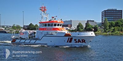
FELIX SAND
Search and Rescue vessel
Current Trip
SAR IN OPERATION
| Time Travelled | 17 h, 39 mins |
|---|---|
| Remaining Time | --- |
| Distance Travelled | 18.37 nm |
| Remaining Distance | --- |
| AVG Speed | 19.8 Knots |
| MAX Speed | 23 Knots |
| AVG Wind | 15.3 knots |
| MAX Wind | 15.7 knots |
| MIN Temp | 5.1°C / 41.18°F |
| MAX Temp | 5.5°C / 41.9°F |
| Draught | 0 m |
| Position Received | 16 h, 40 m ago |
Current Position
| Longitude | --- |
|---|---|
| Latitude | --- |
| Status | Under way using engine |
| Speed | 1.4 Knots |
| Course | 216° |
| Area | Baltic Sea |
| Station | T-AIS |
| Position Received | 16 h, 40 m ago |
Info
Information
The current position of FELIX SAND is in Baltic Sea with coordinates 54.13567° / 10.94815° as reported on 2025-12-14 17:20 by AIS to our vessel tracker app. The vessel's current speed is 1.4 Knots
The vessel FELIX SAND (MMSI: 211390900) is a Search and Rescue vessel It's sailing under the flag of [DE] Germany.
In this page you can find informations about the vessels current position, last detected port calls, and current voyage information. If the vessels is not in coverage by AIS you will find the latest position.
The current position of FELIX SAND is detected by our AIS receivers and we are not responsible for the reliability of the data. The last position was recorded while the vessel was in Coverage by the Ais receivers of our vessel tracking app.
Weather
| Temperature | 5.1°C / 41.18°F |
|---|---|
| Wind Speed | 14 knots |
| Direction | 218° SW |
| Pressure | 1019 hPa |
| Humidity | 90.3 % |
| Cloud Coverage | 87 % |
Featured Company
Last Port Calls
| Port | Arrival | Departure | Time In Port |
|---|---|---|---|
| 2025-12-14 17:09 | 2025-12-14 17:22 | 13 m | |
| 2025-12-14 14:49 | 2025-12-14 16:39 | 1 h | |
| 2025-12-14 12:12 | 2025-12-14 14:19 | 2 h | |
| 2025-12-14 11:10 | |||
| 2025-12-12 09:08 | |||
| 2025-11-28 12:49 | |||
| 2025-11-20 11:39 | 2025-11-20 13:59 | 2 h | |
| 2025-11-20 09:30 | |||
| 2025-11-13 15:28 | 2025-11-14 12:59 | 21 h | |
| 2025-11-13 10:30 | 2025-11-13 12:05 | 1 h |
Most Visited Ports (Last year)
| Port | Arrivals | |
|---|---|---|
| 89 | ||
| 19 | ||
| 13 | ||
| 12 | ||
| 7 | ||
| 5 |
Last Trips
| Origin | Departure | Destination | Arrival | Distance | |
|---|---|---|---|---|---|
| 2025-12-14 16:39 | 2025-12-14 17:09 | 5.31 nm | |||
| 2025-12-14 14:19 | 2025-12-14 14:49 | 5.93 nm | |||
| 2025-12-14 11:10 | 2025-12-14 12:12 | 10.79 nm | |||
| 2025-11-20 09:30 | 2025-11-20 11:39 | 38.02 nm | |||
| 2025-11-13 12:05 | 2025-11-13 15:28 | 24.58 nm | |||
| 2025-11-13 08:58 | 2025-11-13 10:30 | 16.37 nm | |||
| 2025-11-08 15:32 | 2025-11-08 15:40 | 1.66 nm | |||
| 2025-11-06 09:01 | 2025-11-06 14:22 | 16.78 nm | |||
| 2025-10-30 20:04 | 2025-10-30 21:57 | 23.14 nm | |||
| 2025-10-29 12:37 | 2025-10-29 13:56 | 24.00 nm |
Events
| Time | Event | Details | Position / Dest | Info |
|---|---|---|---|---|
| 2025-12-14 17:20 | OUT of Coverage |
54.13567 / 10.94815
Baltic Sea
|
Speed: 1.4 kn Course: 238.9° |
|
| 2025-12-14 16:22 | PORT DEPARTURE |
|
53.99086 / 11.37195
SAR IN OPERATION
|
Speed: 5.2 kn Course: 226° |
| 2025-12-14 16:22 | START Moving |
53.99112 / 11.37245
[DE] TREU SEEKISTE
|
Speed: 4.7 kn Course: 226° |
|
| 2025-12-14 16:10 | STOP Moving |
53.99221 / 11.37494
[DE] TREU SEEKISTE
|
Speed: 0.3 kn Course: 6° |
|
| 2025-12-14 16:09 | PORT ARRIVAL |
|
53.99190 / 11.37388
[DE] TREU SEEKISTE
|
Speed: 3.6 kn Course: 55° |
| 2025-12-14 15:39 | PORT DEPARTURE |
|
53.91247 / 11.43809
SAR IN OPERATION
|
Speed: 6.5 kn Course: 327° |
| 2025-12-14 15:28 | START Moving |
53.89914 / 11.45669
[DE] WISMAR
|
Speed: 4.6 kn Course: 312° |
|
| 2025-12-14 15:25 | STOP Moving |
53.89785 / 11.45904
[DE] WISMAR
|
Speed: 0.3 kn Course: 36° |
|
| 2025-12-14 15:06 | START Moving |
53.89928 / 11.45624
[DE] WISMAR
|
Speed: 3.1 kn Course: 309° |
|
| 2025-12-14 15:02 | Status Changed | Under way using engine Moored |
53.89784 / 11.45929
[DE] WISMAR
|
Speed: Course: 326° |