
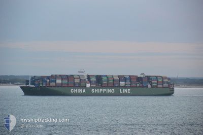
CSCL STAR
Container Ship
Current Trip
| Time Travelled | 3 days |
|---|---|
| Remaining Time | 22 h, 10 mins |
| Distance Travelled | 843.88 nm |
| Remaining Distance | 339.65 nm |
| AVG Speed | 12 Knots |
| MAX Speed | 14.7 Knots |
| AVG Wind | 6.2 knots |
| MAX Wind | 12 knots |
| MIN Temp | 23.3°C / 73.94°F |
| MAX Temp | 26.3°C / 79.34°F |
| Draught | 12.5 m |
| Position Received | 2 d ago |
Current Position
| Longitude | --- |
|---|---|
| Latitude | --- |
| Status | Under way using engine |
| Speed | 12.3 Knots |
| Course | 140° |
| Area | Gulf of Oman |
| Station | T-AIS |
| Position Received | 2 d ago |
Info
Information
The current position of CSCL STAR is in Gulf of Oman with coordinates 25.51462° / 57.22161° as reported on 2025-12-09 15:12 by AIS to our vessel tracker app. The vessel's current speed is 12.3 Knots and is heading at the port of NHAVA SHEVA. The estimated time of arrival as calculated by MyShipTracking vessel tracking app is 2025-12-13 06:48 LT
The vessel CSCL STAR (IMO: 9466867, MMSI: 477963800) is a Container Ship that was built in 2011 ( 14 years old ). It's sailing under the flag of [HK] Hong Kong.
In this page you can find informations about the vessels current position, last detected port calls, and current voyage information. If the vessels is not in coverage by AIS you will find the latest position.
The current position of CSCL STAR is detected by our AIS receivers and we are not responsible for the reliability of the data. The last position was recorded while the vessel was in Coverage by the Ais receivers of our vessel tracking app.
The current draught of CSCL STAR as reported by AIS is 12.5 meters
Weather
| Temperature | 25.7°C / 78.26°F |
|---|---|
| Wind Speed | 11 knots |
| Direction | 40° NE |
| Pressure | 1014 hPa |
| Humidity | 50.1 % |
| Cloud Coverage | --- |
Featured Company
Last Port Calls
| Port | Arrival | Departure | Time In Port |
|---|---|---|---|
| 2025-12-08 04:33 | 2025-12-09 01:35 | 21 h | |
| 2025-12-06 11:33 | 2025-12-07 06:20 | 18 h | |
| 2025-11-05 11:37 | 2025-11-06 13:29 | 1 d | |
| 2025-10-30 02:09 | 2025-10-30 14:55 | 12 h | |
| 2025-10-28 03:20 | 2025-10-29 04:39 | 1 d | |
| 2025-10-21 03:27 | 2025-10-22 16:23 | 1 d | |
| 2025-10-18 07:41 | |||
| 2025-10-07 04:05 | 2025-10-08 18:33 | 1 d | |
| 2025-10-03 18:06 |
Most Visited Ports (Last year)
| Port | Arrivals | |
|---|---|---|
| 3 | ||
| 3 | ||
| 2 | ||
| 2 | ||
| 2 | ||
| 2 |
Last Trips
| Origin | Departure | Destination | Arrival | Distance | |
|---|---|---|---|---|---|
| 2025-12-07 06:20 | 2025-12-08 04:33 | 47.99 nm | |||
| 2025-11-06 13:29 | 2025-12-06 11:33 | 10094.90 nm | |||
| 2025-10-30 14:55 | 2025-11-05 11:37 | 1340.43 nm | |||
| 2025-10-29 04:39 | 2025-10-30 02:09 | 268.31 nm | |||
| 2025-10-22 16:23 | 2025-10-28 03:20 | 507.67 nm | |||
| 2025-10-18 07:41 | 2025-10-21 03:27 | 413.10 nm | |||
| 2025-10-03 18:06 | 2025-10-07 04:05 | 517.03 nm |
Events
| Time | Event | Details | Position / Dest | Info |
|---|---|---|---|---|
| 2025-12-09 15:17 | Status Changed | Default Under way using engine |
25.50182 / 57.23345
INNVA
|
Speed: 12.3 kn Course: 140° |
| 2025-12-09 15:12 | OUT of Coverage |
25.51462 / 57.22161
Gulf of Oman
INNVA
|
Speed: 12.3 kn Course: 140° |
|
| 2025-12-09 13:23 | Detected in Sea | Iranian part of the Gulf of Oman |
25.85433 / 57.01142
Gulf of Oman
INNVA
|
Speed: 13.3 kn Course: 151.4° |
| 2025-12-09 13:20 | Status Changed | Under way using engine Default |
25.86419 / 57.00553
INNVA
|
Speed: 13.3 kn Course: 151° |
| 2025-12-09 13:09 | IN Coverage |
25.85433 / 57.01142
Gulf of Oman
INNVA
|
Speed: 13.3 kn Course: 151.4° |
|
| 2025-12-09 06:13 | Status Changed | Default Under way using engine |
26.25139 / 55.93144
INNVA
|
Speed: 12.8 kn Course: 55.8° |
| 2025-12-09 06:07 | OUT of Coverage |
26.24099 / 55.91139
Persian Gulf
INNVA
|
Speed: 12.8 kn Course: 55.8° |
|
| 2025-12-09 05:52 | Change Sea Area | Omani part of the Persian Gulf United Arab Emirates part of the Persian Gulf |
26.20229 / 55.86946
Persian Gulf
INNVA
|
Speed: 12.9 kn Course: 25° |
| 2025-12-09 05:19 | Status Changed | Under way using engine Default |
26.10639 / 55.79989
INNVA
|
Speed: 12.6 kn Course: 54° |
| 2025-12-09 05:17 | Status Changed | Default Under way using engine |
26.10323 / 55.79508
INNVA
|
Speed: 12.6 kn Course: 51.8° |