
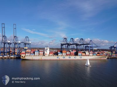
COSCO INDONESIA
Container Ship
Current Trip
| Time Travelled | 4 days |
|---|---|
| Remaining Time | 2 days |
| Distance Travelled | 1989.36 nm |
| Remaining Distance | 965.57 nm |
| AVG Speed | 17.5 Knots |
| MAX Speed | 21.2 Knots |
| AVG Wind | 12.4 knots |
| MAX Wind | 23.9 knots |
| MIN Temp | 3°C / 37.4°F |
| MAX Temp | 18.4°C / 65.12°F |
| Draught | 13.6 m |
| Position Received | 15 h, 24 m ago |
Current Position
| Longitude | 0.37414° |
|---|---|
| Latitude | 36.62384° |
| Status | Under way using engine |
| Speed | 18.4 Knots |
| Course | 76.8° |
| Area | Mediterranean Sea - Western Basin |
| Station | T-AIS |
| Position Received | 15 h, 24 m ago |
Info
Information
The current position of COSCO INDONESIA is in Mediterranean Sea - Western Basin with coordinates 36.62384° / 0.37414° as reported on 2024-04-25 21:42 by AIS to our vessel tracker app. The vessel's current speed is 18.4 Knots and is heading at the port of PIRAEUS. The estimated time of arrival as calculated by MyShipTracking vessel tracking app is 2024-04-28 18:54 LT
The vessel COSCO INDONESIA (IMO: 9448786, MMSI: 477831200) is a Container Ship that was built in 2010 ( 14 years old ). It's sailing under the flag of [HK] Hong Kong.
In this page you can find informations about the vessels current position, last detected port calls, and current voyage information. If the vessels is not in coverage by AIS you will find the latest position.
The current position of COSCO INDONESIA is detected by our AIS receivers and we are not responsible for the reliability of the data. The last position was recorded while the vessel was in Coverage by the Ais receivers of our vessel tracking app.
The current draught of COSCO INDONESIA as reported by AIS is 13.6 meters
Weather
| Temperature | 17°C / 62.6°F |
|---|---|
| Wind Speed | 4 knots |
| Direction | 301° WNW |
| Pressure | 1009.4 hPa |
| Humidity | 66.6 % |
| Cloud Coverage | 17 % |
Featured Company
Last Port Calls
| Port | Arrival | Departure | Time In Port |
|---|---|---|---|
| 2024-04-20 14:56 | 2024-04-21 23:42 | 1 d | |
| 2024-04-17 10:12 | 2024-04-18 02:57 | 16 h | |
| 2024-04-15 04:55 | 2024-04-17 00:37 | 1 d | |
| 2024-04-12 10:31 | 2024-04-13 17:03 | 1 d | |
| 2024-04-01 22:22 | 2024-04-03 23:01 | 2 d | |
| 2024-03-31 04:15 | 2024-04-01 05:21 | 1 d | |
| 2024-03-29 16:01 | 2024-03-30 08:04 | 16 h | |
| 2024-03-27 06:27 | 2024-03-29 10:12 | 2 d | |
| 2024-03-24 22:08 | 2024-03-25 20:11 | 22 h | |
| 2024-03-15 16:35 | 2024-03-17 03:17 | 1 d |
Most Visited Ports (Last year)
| Port | Arrivals | |
|---|---|---|
| 10 | ||
| 10 | ||
| 10 | ||
| 10 | ||
| 10 | ||
| 10 |
Last Trips
| Origin | Departure | Destination | Arrival | Distance | |
|---|---|---|---|---|---|
| 2024-04-18 04:57 | 2024-04-20 16:56 | 473.74 nm | |||
| 2024-04-17 02:37 | 2024-04-17 12:12 | 126.85 nm | |||
| 2024-04-13 18:03 | 2024-04-15 06:55 | 402.42 nm | |||
| 2024-04-04 02:01 | 2024-04-12 11:31 | 3056.04 nm | |||
| 2024-04-01 08:21 | 2024-04-02 01:22 | 257.78 nm | |||
| 2024-03-30 11:04 | 2024-03-31 07:15 | 49.83 nm | |||
| 2024-03-29 13:12 | 2024-03-29 19:01 | 63.60 nm | |||
| 2024-03-25 22:11 | 2024-03-27 09:27 | 395.29 nm | |||
| 2024-03-17 04:17 | 2024-03-25 00:08 | 2935.55 nm | |||
| 2024-03-14 14:58 | 2024-03-15 17:35 | 377.80 nm |
Events
| Time | Event | Details | Position / Dest | Info |
|---|---|---|---|---|
| 2024-04-25 22:03 | Status Changed | Default Under way using engine |
36.66240 / .56470
PIRAEUS
|
Speed: 18.4 kn Course: 76.8° |
| 2024-04-25 21:42 | OUT of Coverage |
36.62384 / .37414
Mediterranean Sea - Western Basin
PIRAEUS
|
Speed: 18.4 kn Course: 76.8° |
|
| 2024-04-25 20:59 | Status Changed | Under way using engine Default |
36.57309 / .13399
PIRAEUS
|
Speed: 18.5 kn Course: 74° |
| 2024-04-25 20:51 | Status Changed | Default Under way using engine |
36.56970 / .11874
PIRAEUS
|
Speed: 18.7 kn Course: 74.1° |
| 2024-04-25 16:08 | Change Sea Area | Algerian part of the Mediterranean Sea - Western Basin Spanish part of the Alboran Sea |
36.20669 / -1.65548
Mediterranean Sea - Western Basin
PIRAEUS
|
Speed: 19.3 kn Course: 78.9° |
| 2024-04-25 16:08 | Status Changed | Under way using engine Default |
36.20669 / -1.65548
PIRAEUS
|
Speed: 19.3 kn Course: 76° |
| 2024-04-25 16:00 | Status Changed | Default Under way using engine |
36.19758 / -1.70592
PIRAEUS
|
Speed: 19 kn Course: 74.7° |
| 2024-04-25 14:44 | Status Changed | Under way using engine Default |
36.07488 / -2.17251
PIRAEUS
|
Speed: 18.2 kn Course: 82° |
| 2024-04-25 14:31 | IN Coverage |
36.07488 / -2.17251
Alboran Sea
PIRAEUS
|
Speed: 18.2 kn Course: 81.6° |
|
| 2024-04-25 12:58 | OUT of Coverage |
36.03464 / -2.81555
Alboran Sea
PIRAEUS
|
Speed: 17.7 kn Course: 95° |