
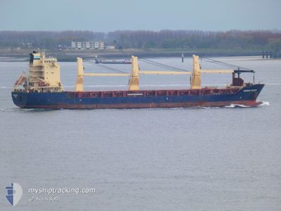
CONDOR BILBAO
General Cargo
Current Trip
PACTB
| Time Travelled | 9 days |
|---|---|
| Remaining Time | --- |
| Distance Travelled | 2646.88 nm |
| Remaining Distance | --- |
| AVG Speed | 12.4 Knots |
| MAX Speed | 18 Knots |
| AVG Wind | 15.8 knots |
| MAX Wind | 33 knots |
| MIN Temp | 3.3°C / 37.94°F |
| MAX Temp | 18°C / 64.4°F |
| Draught | 7.6 m |
| Position Received | 3 d ago |
Current Position
| Longitude | --- |
|---|---|
| Latitude | --- |
| Status | Under way using engine |
| Speed | 12.9 Knots |
| Course | 17.8° |
| Area | South Pacific Ocean |
| Station | T-AIS |
| Position Received | 3 d ago |
Info
Information
The current position of CONDOR BILBAO is in South Pacific Ocean with coordinates -53.05370° / -70.53695° as reported on 2025-12-17 04:46 by AIS to our vessel tracker app. The vessel's current speed is 12.9 Knots
The vessel CONDOR BILBAO (IMO: 9473250, MMSI: 209321000) is a General Cargo that was built in 2012 ( 13 years old ). It's sailing under the flag of [CY] Cyprus.
In this page you can find informations about the vessels current position, last detected port calls, and current voyage information. If the vessels is not in coverage by AIS you will find the latest position.
The current position of CONDOR BILBAO is detected by our AIS receivers and we are not responsible for the reliability of the data. The last position was recorded while the vessel was in Coverage by the Ais receivers of our vessel tracking app.
The current draught of CONDOR BILBAO as reported by AIS is 7.6 meters
Weather
| Temperature | 17.1°C / 62.78°F |
|---|---|
| Wind Speed | 13 knots |
| Direction | 360° N |
| Pressure | 1006.9 hPa |
| Humidity | 97 % |
| Cloud Coverage | 100 % |
Featured Company
Last Port Calls
| Port | Arrival | Departure | Time In Port |
|---|---|---|---|
| 2025-12-11 13:16 | 2025-12-11 19:52 | 6 h | |
| 2025-12-04 15:13 | 2025-12-07 15:28 | 3 d | |
| 2025-11-27 08:54 | 2025-11-29 13:35 | 2 d | |
| 2025-11-17 19:56 | 2025-11-19 16:08 | 1 d | |
| 2025-11-05 15:34 | 2025-11-07 13:35 | 1 d | |
| 2025-10-22 04:48 | 2025-10-22 23:01 | 18 h | |
| 2025-10-17 00:32 | 2025-10-19 10:04 | 2 d | |
| 2025-10-10 01:25 | 2025-10-11 20:58 | 1 d | |
| 2025-10-07 10:44 | 2025-10-08 22:03 | 1 d | |
| 2025-10-01 22:06 | 2025-10-06 17:56 | 4 d |
Most Visited Ports (Last year)
| Port | Arrivals | |
|---|---|---|
| 5 | ||
| 4 | ||
| 3 | ||
| 3 | ||
| 3 | ||
| 2 |
Last Trips
| Origin | Departure | Destination | Arrival | Distance | |
|---|---|---|---|---|---|
| 2025-12-07 15:28 | 2025-12-11 13:16 | 637.10 nm | |||
| 2025-11-29 13:35 | 2025-12-04 15:13 | 10.08 nm | |||
| 2025-11-19 16:08 | 2025-11-27 08:54 | 510.90 nm | |||
| 2025-11-07 13:35 | 2025-11-17 19:56 | 2307.95 nm | |||
| 2025-10-22 23:01 | 2025-11-05 15:34 | 4261.09 nm | |||
| 2025-10-19 10:04 | 2025-10-22 04:48 | 800.48 nm | |||
| 2025-10-11 20:58 | 2025-10-17 00:32 | 374.13 nm | |||
| 2025-10-08 22:03 | 2025-10-10 01:25 | 293.13 nm | |||
| 2025-10-06 17:56 | 2025-10-07 10:44 | 149.36 nm | |||
| 2025-08-30 01:23 | 2025-10-01 22:06 | 6657.20 nm |
Events
| Time | Event | Details | Position / Dest | Info |
|---|---|---|---|---|
| 2025-12-17 04:54 | Status Changed | Default Under way using engine |
-53.02679 / -70.52283
PACTB
|
Speed: 12.9 kn Course: 17.8° |
| 2025-12-17 04:46 | OUT of Coverage |
-53.05370 / -70.53695
South Pacific Ocean
|
Speed: 12.9 kn Course: 17.8° |
|
| 2025-12-17 02:25 | Status Changed | Under way using engine Default |
-53.54692 / -70.77184
PACTB
|
Speed: 13.3 kn Course: 16° |
| 2025-12-17 02:21 | Status Changed | Default Under way using engine |
-53.55866 / -70.77774
PACTB
|
Speed: 13.3 kn Course: 17.3° |
| 2025-12-17 02:17 | Status Changed | Under way using engine Default |
-53.57396 / -70.78555
PACTB
|
Speed: 13.3 kn Course: 18° |
| 2025-12-17 02:03 | IN Coverage |
-53.57396 / -70.78555
South Pacific Ocean
|
Speed: 13.3 kn Course: 17.3° |
|
| 2025-12-17 00:26 | Status Changed | Default Under way using engine |
-53.89332 / -71.16097
PACTB
|
Speed: 14.5 kn Course: 63.2° |
| 2025-12-17 00:20 | OUT of Coverage |
-53.90514 / -71.19931
South Pacific Ocean
|
Speed: 14.5 kn Course: 63.2° |
|
| 2025-12-16 21:40 | Change Sea Area | Chilean (disputed - Chilean point of view) part of the South Pacific Ocean Panamanian part of the Caribbean Sea |
-53.67743 / -72.15196
South Pacific Ocean
|
Speed: 15.4 kn Course: 132.9° |
| 2025-12-16 21:39 | Status Changed | Under way using engine Default |
-53.67457 / -72.15715
PACTB
|
Speed: 15.6 kn Course: 134° |