
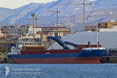
CELTIC SPIRIT
General Cargo
Current Trip
| Trip Time | 7 days |
|---|---|
| Trip Distance | 786.42 nm |
| AVG Speed | 9 Knots |
| MAX Speed | 11.5 Knots |
| Draught | 5.4 m |
| AVG Wind | 10.3 knots |
| MAX Wind | 20 knots |
| MIN Temp | 11.6°C / 52.88°F |
| MAX Temp | 21.3°C / 70.34°F |
| Position Received | 5 d ago |
Current Position
| Longitude | 9.93293° |
|---|---|
| Latitude | 37.29604° |
| Status | At anchor |
| Speed | 0.1 Knots |
| Course | 97° |
| Area | Mediterranean Sea - Western Basin |
| Station | T-AIS |
| Position Received | 5 d ago |
Info
Information
The current position of CELTIC SPIRIT is in Mediterranean Sea - Western Basin with coordinates 37.29604° / 9.93293° as reported on 2024-04-27 17:15 by AIS to our vessel tracker app. The vessel's current speed is 0.1 Knots and is currently inside the port of BIZERTE.
The vessel CELTIC SPIRIT (IMO: 9365491, MMSI: 304242000) is a General Cargo that was built in 2007 ( 17 years old ). It's sailing under the flag of [AG] Antigua Barbuda.
In this page you can find informations about the vessels current position, last detected port calls, and current voyage information. If the vessels is not in coverage by AIS you will find the latest position.
The current position of CELTIC SPIRIT is detected by our AIS receivers and we are not responsible for the reliability of the data. The last position was recorded while the vessel was in Coverage by the Ais receivers of our vessel tracking app.
The current draught of CELTIC SPIRIT as reported by AIS is 5.4 meters
Weather
| Temperature | 18.3°C / 64.94°F |
|---|---|
| Wind Speed | 12 knots |
| Direction | 316° NW |
| Pressure | 1020 hPa |
| Humidity | 46.7 % |
| Cloud Coverage | 81 % |
Featured Company
Last Port Calls
| Port | Arrival | Departure | Time In Port |
|---|---|---|---|
| 2024-04-29 21:20 | |||
| 2024-04-22 16:26 | 2024-04-22 19:30 | 3 h | |
| 2024-04-17 06:14 | 2024-04-17 16:30 | 10 h | |
| 2024-04-14 01:58 | 2024-04-14 15:09 | 13 h | |
| 2024-04-13 06:56 | 2024-04-13 16:10 | 9 h | |
| 2024-04-09 18:44 | 2024-04-10 18:03 | 23 h | |
| 2024-04-09 18:34 | 2024-04-09 18:36 | 1 m | |
| 2024-04-04 05:57 | 2024-04-07 10:09 | 3 d | |
| 2024-03-23 14:06 | 2024-03-29 11:34 | 5 d | |
| 2024-03-20 07:21 | 2024-03-20 13:21 | 5 h |
Most Visited Ports (Last year)
| Port | Arrivals | |
|---|---|---|
| 6 | ||
| 5 | ||
| 4 | ||
| 4 | ||
| 2 | ||
| 2 |
Last Trips
| Origin | Departure | Destination | Arrival | Distance | |
|---|---|---|---|---|---|
| 2024-04-22 21:30 | 2024-04-29 22:20 | 786.42 nm | |||
| 2024-04-17 17:30 | 2024-04-22 18:26 | 1134.89 nm | |||
| 2024-04-14 16:09 | 2024-04-17 07:14 | 366.25 nm | |||
| 2024-04-13 17:10 | 2024-04-14 02:58 | 98.18 nm | |||
| 2024-04-10 19:03 | 2024-04-13 07:56 | 569.30 nm | |||
| 2024-04-09 19:36 | 2024-04-09 19:44 | 0.33 nm | |||
| 2024-04-07 11:09 | 2024-04-09 19:34 | 376.95 nm | |||
| 2024-03-29 11:34 | 2024-04-04 06:57 | 903.83 nm | |||
| 2024-03-20 13:21 | 2024-03-23 14:06 | 665.94 nm | |||
| 2024-03-16 22:00 | 2024-03-20 07:21 | 501.91 nm |
Events
| Time | Event | Details | Position / Dest | Info |
|---|---|---|---|---|
| 2024-04-29 21:56 | STOP Moving |
37.26804 / 9.87354
[TN] BIZERTE
|
Speed: Course: 55° |
|
| 2024-04-29 21:20 | PORT ARRIVAL |
|
37.27108 / 9.88162
[TN] BIZERTE
|
Speed: 6.5 kn Course: 233° |
| 2024-04-29 20:53 | START Moving | 2.46 nm, North East of BIZERTE |
37.27711 / 9.91073
TNBIZ
|
Speed: 3.7 kn Course: 177° |
| 2024-04-27 17:20 | Status Changed | Default At anchor |
37.29619 / 9.93293
TNBIZ
|
Speed: 0.1 kn Course: 97° |
| 2024-04-27 17:15 | Status Changed | At anchor Default |
37.29604 / 9.93293
TNBIZ
|
Speed: Course: -1° |
| 2024-04-27 17:15 | OUT of Coverage |
37.29604 / 9.93293
Mediterranean Sea - Western Basin
|
Speed: 0.1 kn Course: 162.5° |
|
| 2024-04-27 16:50 | Status Changed | Default At anchor |
37.29608 / 9.93284
TNBIZ
|
Speed: 0.1 kn Course: 92° |
| 2024-04-27 16:45 | Status Changed | At anchor Default |
37.29593 / 9.93282
TNBIZ
|
Speed: Course: -1° |
| 2024-04-27 16:45 | IN Coverage |
37.29593 / 9.93282
Mediterranean Sea - Western Basin
|
Speed: 0.1 kn Course: 210.6° |
|
| 2024-04-27 07:18 | OUT of Coverage |
37.29597 / 9.93493
Mediterranean Sea - Western Basin
|
Speed: 0.1 kn Course: 209.2° |